- Top Natural Attractions
-
National Parks
- Archipelago
- Bothnian Bay
- Bothnian Sea
- Ekenäs Archipelago
- Gulf of Finland
- Helvetinjärvi
- Hiidenportti
- Hossa
- Isojärvi
- Kauhaneva-Pohjankangas
- Koli
- Kolovesi
- Kurjenrahka
- Lauhanvuori
- Leivonmäki
- Lemmenjoki
- Liesjärvi
- Linnansaari
- Nuuksio
- Oulanka
- Pallas-Yllästunturi
- Patvinsuo
- Petkeljärvi
- Puurijärvi and Isosuo
- Pyhä-Häkki
- Pyhä-Luosto
- Päijänne
- Repovesi
- Riisitunturi
- Rokua
- Salla
- Salamajärvi
- Seitseminen
- Sipoonkorpi
- Southern Konnevesi
- Syöte
- Teijo
- Tiilikkajärvi
- Torronsuo
- Urho Kekkonen National Park
- Valkmusa
- World Heritage Sites
- National Hiking Areas
- Wilderness Areas
-
Other Nature Sites
- Aulanko
- Auttiköngäs
- Dagmar Park
- Friendship Park
- Hepoköngäs
- Hetta Area
- Hämeenkangas
- Iivaara
- Ilmakkiaapa
- Kairijoki
- Kevo
- Kivitunturi
- Korouoma
- Laajalahti
- Langinkoski
- Luiro Mires
- Malla
- Martimoaapa
- Meiko
- Neitvuori-Luonteri
- Näränkä
- Porkkala
- Punkaharju
- Rahja
- Sanginjoki
- Siikalahti Nature Reserve
- Simojärvi and Soppana
- Sompio
- Teuravuoma - Kivijärvenvuoma
- Valtavaara-Pyhävaara
- Viiankiaapa
- Ärjänsaari
- Öjen
- Uddskatan
- Hiking Trails
- Huts
-
Historical Sites
- Hunting Pits on Jyppyrä Hill
- Hytermä
- Kajaani Castle Ruins
- Kurjenpolvi Graveyard
- Kuusisto Bishop’s Castle Ruins
- Langinkoski Imperial Fishing Lodge
- Pakasaivo and the Kirkkopahta Seida Rock
- Rapola Hill Fort
- Raseborg Castle Ruin
- Seili Island
- Svartholma Sea Fortress
- The Grounds of Kaapin Jouni
- Vallisaari
- Äkässaivo and Seitapahta
- Örö Fortress Island
- Nature Centres
- Accessible Destinations
- Geoparks
Ränkänsaari Open Wilderness Hut
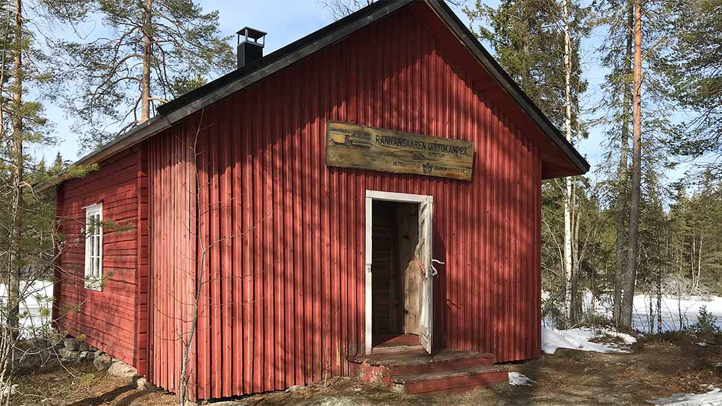
Ränkänsaari Open Wilderness Hut. Photo: Eeva Pulkkinen.

Ränkänsaari Open Wilderness Hut can be heated by an oven in the middle of the hut. Photo: Eeva Pulkkinen.

Ränkänsaari Open Wilderness Hut was originally built for timber floating men. Photo: Eeva Pulkkinen.

A lean-to shelter by the Ränkänsaari Open Wilderness Hut. Photo: Eeva Pulkkinen.
Ränkänsaari open wilderness hut is located on the northern end of lake Iivantiirajärvi, on a small island in a middle of a stream flowing from lake Aidasjärvi to lake Iivantiirajärvi. Ränkänsaari hut is amazingly big for an open wilderness hut. Originally it served as a rest hut for timber floating men.
Type
Open wilderness hut for 8 persons
Location
Kainuu
Maps
- Excursionmap.fi
- Maastokartta / Terrain Map nro Q542, 1:50 000
Coordinates
Ränkänsaari Open Wilderness Hut coordinates: Euref-Fin (~ WGS84) lat: 64° 24.0610' lon: 29° 31.8733' ETRS-TM35FIN: N: 7144132 E: 622005
Facilities
- Stove.
- A lean-to shelter and fireplace in 50 metres.
Notices
- It is allowed to bring pets in the hut.
- Safety on hiking
Waste Management
Every hiker is responsible for his or her own waste. Read more about Hiking Without Littering.
Maintenance and Management
The area is managed by Metsähallitus, Parks & Wildlife Finland, Ostrobothnia–Kainuu.
More information from Kuhmo Visitor Centre Petola, tel.int. 0206 39 6380.
Guidelines on using Open Wilderness Hut

Excursionmap.fi is a free map service provided by Metsähallitus. It can be used to search destinations, choose map layers and print maps.
Outdoor Etiquette

1. Respect nature.
2. Mainly use marked trails.
3. Camp only where it is allowed.
4. Light your campfire only where it is allowed.
5. Do not litter.