
Starting Points for Trails
Hiking trails begin at Petkeljärvi Camping Ground. The exact starting point is on Petkeljärventie road near the Outdoor Centre sauna by the lake shore.
Nature Trail

Kuikan Kierros Nature Trail, 6,5 km Circle Trail
When there is no snow on the ground. Trail leads through varying landscape up and down ridges. No winter maintenance.
Hikers should reserve two to three hours to see this trail.
Services
The nature trail's starting and end points are situated near Petkeljärvi Outdoor Centre.
Sights
Magnificent ridges. Aservices fen meadow, which is maintained as a traditional landscape. The meadow is located east of Lake Kuikkalampi between a ridge and Lake Petkeljärvi.
Route Description
The trail should be travelled clockwise. It is marked with yellow circles.
Kuikan Kierros Trail in Excursionmap.fi.
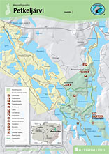
Kuikan Kierros Nature Trail (6,5 km) leads through varying landscape up and down ridges. It is so beautiful that the atmosphere is almost fairy tale-like. At first the trail goes around Kokkolahti Bay, after which visitors may walk 2 km along a narrow ridge to Korkeasärkkä and back. Otherwise after Kokkolahti Bay the trail leads to the ridge between Lakes Savulampi and Syväjärvi and on towards the River Tuomipuro. The trail crosses paths with Taitajan taival Trail at Lake Ruunulampi. From there the nature trail continues towards Lake Pieni Joutenjärvi. Visitors walk through spruce mires along duckboards and emerge into Mustalampi mire. After crossing the road the trail leads downwards to the clear waters of Lake Kuikkalampi, where visitors can spot beavers' burrows. From there the trail rises up onto the ridge again. On the eastside of this ridge there is a fen meadow, where local people used to harvest hay for their livestock for winter. The rest of the trail leads across spruce heath, where visitors can see signs of forest fires past on the trees.
A connecting trail to Taitajan taival Trail.

Circle Trail
Harjupolku Trail, 3,5 km Circle Trail
When there is no snow on the ground. Trail circles through varying landscape. No winter maintenance.
Hikers should reserve one to two hours to see this trail.
Services
The nature trail's starting and end points are situated near Petkeljärvi Outdoor Centre.
Route Description
The trail should be travelled clockwise. It is marked with yellow circles.
Harjupolku Trail (3,5 km) circles Lake Savulampi through varying landscape. The trail follows the route of Kuikan kierros nature trail for part of the way. At first the trail goes around Kokkolahti Bay, after which visitors have to possibility of going to Korkeasärkkä (2 km) and back. Otherwise after Kokkolahti Bay the trail leads to the ridge between Lakes Savulampi and Syväjärvi and on towards the River Tuomipuro. The trail crosses paths with Taitajan taival Trail at Lake Ruunulampi. At this point hikers should turn right back towards Kokkolahti Bay. From Kokkolahti Bay the trail follows the same route, which hikers came along in the opposite direction to Cape Petraniemi.
A connecting trail to Taitajan taival Trail.
Other Trails

Korkeasärkän polku Trail, 2 km/each way
When there is no snow on the ground. Quite demanding terrain. No winter maintenance.
Hikers should reserve one to two hours to see this trail.
Route Description
Korkeasärkän polku Trail (2 km) begins at the crossroads between Kokkolahti Bay and Lake Savulampi. The trail leads to the end of the narrow Korkeasärkkä Ridge and back again along the same path. Lohisalmi Sound is located at the end of the ridge. A view of Lake Valkiajärvi opens to the east and a view of the narrow Lake Kaitajärvi to the west.

Taitajan taival Trail, 31 km/each way
Taitajan taival Trail (in Finnish) (31 km) is the oldest hiking trail in North Karelia It begins at Cape Petraniemi, by Lake Petkeljärvi and ends in the village of Mekrijärvi. Taitajan taival Trail is of medium difficulty. Taitajan taival Trail can be travelled when the ground is not frozen. The trail has signposts and is also marked with orange circles. Taitajan taival Trail leads along the top of the row of ridges between Petkeljärvi and Putkelanharju. A kilometre of the trail is within the National Park's boundaries. A majority of the trail (from Lake Petkeljärvi to Lake Linnalampi) is maintained by Metsähallitus.
Hiking Structures
There are 4 lean-to shelters along the trail. The lean-to shelter closest to the park is at the shore of Keltasilmä Pond. These resting spots also have wood sheds and dry toilets.
Sights
Magnificent views of the ridges, which surround the area's lakes.
Maps
Terrain maps are useful to have with when going on a hike. Basic terrain maps 4243 06, 4243 09 and 4243 12 are for this area.
Connected to: The trail is part of the Karelian Circuit, which is a network of trails.
Cross-country Skiing Trails
Skiing is permitted in the park, but there are no open trails in the park.
During the Pogostan Hiihto ski event (ilu.fi) the open trail runs on the west side of the park. Thousands of skiers take part in this classical cross country skiing race, which has different route possibilities and different classes to choose from. Skiers can choose the 53 km route or the 75 km one. There is a participation fee for the race. The start and finish line are located in Ilomantsi at the Parppein urheilukeskus sports centre. The event has been arranged annually from 1977.
Boating and Canoeing Routes
There are no marked routes in Petkeljärvi National Park, but a waterway which flows into the near-by River Koitajoki is good for boating and canoeing. In 2003 Petkeljärvi National Park hosted the Finnish National wilderness kayaking championship event.
The River Koitajoki, which is over 200 km long, is known as a good canoeing destination. The river flows partially east of the border in Russia and empties into Lake Nuorajärvi northwest of the National Park. It is also possible to canoe from Lake Petkeljärvi to Lake Koitere in Patvinsuo National Park. The distance between these two lakes is 80 km. Another possibility is to canoe from Lake Petkeljävi 20 km southward to Mutalahti Bay.
Maps: Koitajoen vesistömatkailukartta -waterway map, Aarniseikkailujen Koitajoki, 1:30 000.

Petkeljärvi Brochure
Check for Warnings
 When forest and grass fire warnings (en.ilmatieteenlaitos.fi) are in effect, fire is only allowed at covered campfire sites that have a flue. A fire can be also lit in fireplaces at wilderness and other huts. Always use extreme caution when handling fire. The one who lights a fire is always responsible for its safe use. Please note, that making fire at these campfire sites can be banned locally.
Gathering at the campfire sites increases the risk of coronavirus infection. Guidelines concerning coronavirus COVID-19.
