
The Hetta Area is located in the municipality of Enontekiö on the north side of Pallas-Yllästunturi National Park. Main road 93 leads through the area.

Directions
By Public Transportation
- A coach (matkahuolto.fi) travels daily from Rovaniemi to Hetta.
- There are flights to Kittilä (finavia.fi) all year round. From Kittilä airport visitors can continue their journey by coach or by airport taxi (tosilappi.fi).
- The closest railway stations (vr.fi) are in Rovaniemi and Kolari. From each of them you can get to Hetta by coach.
By Car
- Hetta can be reached by car from Kittilä, Muonio and Kilpisjärvi as well as from Kautokeino in Norway.
- Driving directions to Fell Lapland Visitor Centre.
Starting Points for Excursions
- There are starting points for the trails in the area all around the village of Hetta.
Maps
Electronic Maps


- Excursionmap.fi of Metsähallitus
- National Land Survey of Finland Map Service (karttapaikka.fi)
- The map of Jyppyrä trails (pdf 4.5 MB, julkaisut.metsa.fi)
Other Maps
- The map of Jyppyrä trails.
- Hetta Pallas Ylläs, waterproof map, 1:50 000, Calazo 2022.
- Pöyrisjärven erämaa, waterproof map, 1:50 000, Calazo 2022.
- Pallas Ylläs Aakenus, 1:50 000. Calazo 2016.
- Pallas, Hetta, Olos Outdoor map, 1:50 000. Karttakeskus 2014.
- Hetta ski trail map (Latukartta Hetan ladut), 1:70, 000.
- GT tiekartta Pohjois-Suomi: GT Roadmap Finland North, 2013, 1:400 000.

Hetta–Jyppyrä Area
Trail Map
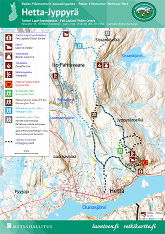
Hetta-Jyppyrä area trail map, Pdf-file 4,5 Mb (julkaisut.metsa.fi)