Nordkalottleden Trail Menu
Nordkalott Trail Directions and Maps

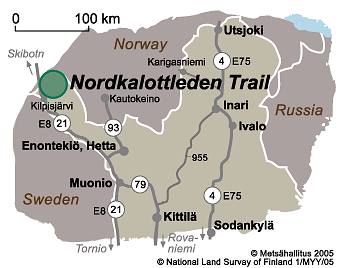
Directions to Kilpisjärvi
By Car
- Kilpisjärvi is on main road 21 (E8).
By Public Transportation
- Coaches travel from Rovaniemi to Kilpisjärvi. During summer there a two coaches daily.
- Coaches (matkahuolto.fi) also travel from Kolari to Kilpisjärvi. In this case you will have to change coaches in Muonio.
- There are flights to Kittilä all year round. From Kittilä airport visitors can continue their journey by coach or by airport taxi (enontekiolapland.com).
- Trains (vr.fi) travel from Helsinki to Rovaniemi and Kolari, from where you can continue by coach.
Maps
Electronic Maps

Other Maps by Sections
Entire Trail
- Fjällvandra längs Nordkalottleden, hiking guide, Calazo 2020.
- Fjällkartan can be bought from Sweden
- Norge-Serien Turkart can be bought from Norway
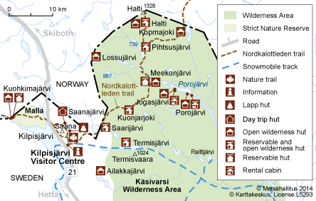
Maps: Kilpisjärvi - Kautokeino
- Halti Kilpisjärvi Pältsa, waterproof map, 1:50 000, Calazo 2021.
- Halti Kilpisjärvi Pältsan, water resistant outdoor map, 1:50 000 / 1:25 000. Karttakeskus 2021.
- Reisa nasjonalpark og Nordreisa sör, 1:50.000. Calazo.
- Reisadalen 10154 and Guovdageaidnu 10165, 1:50 000. Norge-Serien.
- Nordeisa, 1:100 000. Norge-Serien.
- Retkeily GT Pohjois-Suomi: Outdoor GT Map Northern Finland, 2016, 1:400 000. Karttakeskus.
Maps: Kilpisjärvi - Abisko
- Halti Kilpisjärvi Pältsa, waterproof map, 1:50 000, Calazo 2021.
- Halti Kilpisjärvi Pältsan, water resistant outdoor map, 1:50 000 / 1:25 000. Karttakeskus 2021.
- Treriksröset, Abisko & Kiruna. 1:100 000. Calazo.
- Fjällkartan BD1 Treriksröset - Råstojaure, 1:100 000.
- Fjällkartan BD6 Abisko - Kebnekai - Narvik, 1:100 000.
Maps: Abisko - Kvikkjokk or Sulitjelma
- Kungsleden: Kebnekaise, Abisko & Riksgränsen, 1:50 000. Calazo.
- Kebnekaisefjällen & Narvik, 1:100 000. Calazo.
- Sarek & Padjelanta, 1:100 000. Calazo.
- Fjällkartan BD6 Abisko - Kebnekai - Narvik, 1:100 000.
- Fjällkartan BD7 Sitasjaure - Ritsem, 1:100 000.
- Fjällkartan BD9 Padjelanta - Sulitelma, 1:100 000.
- Fjällkartan BD10 Sareks nationalpark, 1:100 000.
Other Maps
- Retkeily GT Pohjois-Suomi: Outdoor GT Map Northern Finland, 2016, 1:400 000. Karttakeskus.


