Other Maps


Lihapyörre Trail, Accessible, 200 metres / each way
Available when the ground is unfrozen, travel time (there and back) less than 30 minutes.
Category:  an easy wheelchair trail
Lihapyörre Accessible Trail runs by the bend of River Somerjoki, in a beautiful river and esker scenery. The Lihapyörre parking area is also a starting point for the hiking trails to the Värikallio Cliffs and towards Lake Laukkujärvi, but these trails are not accessible to all. There is no winter maintenance on the trail.
Starting Point
Lihapyörre parking area
Driving directions: The distance from the visitor centre to the Lihapyörre parking area is 11.5 km.
Drive past the Hossa Visitor Centre and continue along Jatkonsalmentie Road for 3.3 km. Turn to the right onto Pistonlehdontie Road and continue for 6.4 km. Turn to the right onto a road that takes you to Lihapyörre. From the crossroads, the distance to the parking area is 1.7 km.
Coordinates: Euref-Fin (WGS84) lat: 65° 30.4386 lon: 29° 21.2776'
ETRS-TM35FIN N: 7267031m E: 608906m
Hiking Structures
At Lihapyörre, you will find a lean-to shelter and a campfire site that are accessible to all, as well as an accessible dry toilet (take toilet paper with you). In addition, there is an accessible platform structure in front of the lean-to shelter. It is suitable for fishing and the landing of boats. From the platform, you can admire River Somerjoki, listen to its poetically babbling sound and catch grayling and other fish.
Trail Description
The trail has been marked with yellow signs. There is no danger of getting lost on this trail. The terrain is level and there are no altitude differences. The trail has been surfaced with stone dust.
Please Note
Along the trail and to the starting point, you are also allowed to drive with electric vehicles, such as an electric wheelchair or an electric scooter. The distance (in one direction) is 11.5 km. When going to the starting point, you will have to drive on a public road, so driving is at your own risk. In the Hossa National Park, the speed limit for vehicles is 30 km/h and for electric vehicles 15/km hour.

Huosilampi Trail, Accessible, 500 metres / each way
Available when the ground is unfrozen, travel time (there and back) less than one hour.
Category:  a demanding wheelchair trail
The Huosilampi Accessible Trail is the part of Hossa that is the easiest to access. Actually, the nature trail is not located in the national park's territory, but it is part of the park entity. In the Huosilampi area, you can fish from the accessible jetties, travel along the duckboards, view the mire landscape and enjoy the peace and quiet of Hossa at the large lean-to shelter and at campfire sites. There is no winter maintenance on the trail.

Starting Point
The visitor centre's day parking area opposite to the visitor centre. The distance from the visitor centre is roughly 50 metres.
Coordinates: Euref-Fin (WGS84) lat: 65° 28.1255' lon: 29° 31.0366'
ETRS-TM35FIN N: 7263029 E: 616597m
Hiking Structures
There is a large lean-to shelter at the southern end of the trail that runs along the shore of Huosilampi Pond. There is an accessible dry toilet by the lean-to shelter. There are three accessible fishing jetties, as well as a campfire site and eating space along the trail. At the northern end of the trail, you will find duckboards, accessible to all, across a mire area, and information boards on the natural features of the mires in the area.
Trail Description
The trail has not been marked, but there is no risk of getting lost on this trail. In the initial section of the trail, when descending onto the shore of Huosilampi Pond, there is a 150-metre long section that has a gradient of over 5% and therefore, those using a wheelchair may need an assistant for pushing the wheelchair. Most of the trail runs on the level of the shore of Huosilampi Pond.
On the shore of Huosilampi Pond, the trail branches into two. One branch goes to a lean-to shelter at the southern end of the pond and the other branch to a mire area at the northern end of the pond. If you visit both ends of the pond, the distance is about 1.3 km, measured from the day parking area. The trail has been surfaced with stone dust and the duckboards are built of planks.
Please Note
The trail is easily accessible and the services provided by the visitor centre are in the vicinity. There is also a short distance from the trail to the Karhunkainalo Camping Ground, which provides accessible accommodation, sauna and shower facilities, as well as an accessible service building for caravanners.
From the northern end of the trail, a gravel trail continues that is about one metre wide and accessible to all. For the final section, the trail runs along a gravel road to the Huosiusjärvi rental cabin, accessible to all. The visitor centre will provide you with more information on the accommodation at the Karhunkainalo Camping Ground and the Huosiusjärvi rental cabin.
Muikkupuron mutka Trail, Accessible, 1.5 km / each way
Available when the ground is unfrozen, travel time about one hour by wheelchair / each way, on foot 0,5 h.
Category: a demanding wheelchair trail,  an easy trail
The Muikkupuron mutka Trail accessible Trail - accessible to all - is meant for hikers and cyclists. The trail runs through a gorgeous esker and shore landscape, taking you to the Muikkupuro, which is a wriggling, crystal-clear stream, is stunningly beautiful. The surroundings of the Muikkupuro lean-to shelter are the most beautiful scenery in Hossa. The lean-to shelter is located between two crystal-clear lakes that are connected by a stream babbling by the lean-to shelter. At Muikkupuro, you can admire the sandy heaths and clear waters that are characteristic of Hossa. There is no winter maintenance on the trail.

Starting Point
Hossalaislammet parking area
Driving directions: Drive past the Hossa Visitor Centre and continue along Jatkonsalmentie Road for 3.3 km. Turn to the right onto Pistonlehdontie Road. Drive for about 3.3 km, and the Hossalaislammet parking area is located on the left side of the road.
Coordinates: Euref-Fin (WGS84) lat: 65° 29.2077' lon: 29° 24.2176'
ETRS-TM35FIN N: 7264832m E: 611258m
Hiking Structures
Muikkupuro lean-to shelter, an accessible dry toilet by the lean-to shelter and by the parking area.
Along the trail there are benches for taking a break. The Muikkupuro lean-to shelter is accessible to all and there is a campfire site in front of the lean-to shelter. There is also an accessible dry toilet at Muikkupuro as well as by the Hossalaislammet parking area (take toilet paper with you). By the mouth of the stream, on the side of Lake Keski-Valkeainen, you will find a sandy beach for taking a dip in the water. However, the beach is not accessible to all, because of a small shore bank.

Trail Description
Trail markings: red signs
Length: 1.5 km in one direction
Altitude difference: about 20 m
The Muikkupuron mutka Trail is part of the Kokalmuksen kierros Trail.
The Muikkupuro lean-to shelter is located between two crystal-clear lakes, Iso-Valkeainen and Keski-Valkeainen, which are connected by a stream babbling by the lean-to shelter. At Muikkupuro, you can admire the sandy heaths and clear waters that are characteristic of Hossa. You can also canoe to Muikkupuro from accessible rental huts, Hirvastupa and Peurapirtti, which are located on the shores of Lake Iso-Valkeainen.
The trail starts from the Hossalaislammet parking area. The trail runs along spacious pine heaths and is 1‒1.5 metres wide. There are gentle ascents and descents midway along the trail. In the end part of the trail there is steep downhill, where is advisable to have an assistant. The trail has been surfaced with stone dust and the terrain is level.
Please Note
The trail runs along a mountain biking trail for about 500 metres, so you may meet mountain bikers along the trail.
Along the trail and to the starting point, you are also allowed to drive with electric vehicles, such as an electric wheelchair or an electric scooter. The distance from the visitor centre to the parking area is 6.6 km. Travelling on the road is always at your own risk. When travelling manually by wheelchair on the terrain, please check that the front wheels are high and wide enough. You can also use a nose gear wheel that is fixed to the wheelchair.
There is a boat landing site on the northern side of the Muikkupuro lean-to shelter, on the shore of Lake Iso-Valkeainen. You can also land there with an assistant. Hirvastupa and Peurapirtti are accessible rental huts on the shore of Lake Iso-Valkeainen. From the huts, you can canoe to the destination. The distance is about 1.5 km.
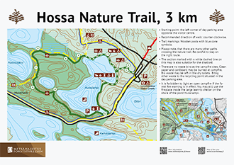
Hossa Nature Trail, 3 km, Circle Trail
Available when the ground is unfrozen, travel time about one hour.
Category:  intermediate
On the 3-km-long nature trail running around Huosilampi Pond, you can explore the natural features of the Hossa National Park. It is like Hossa in a miniature size. There is no winter maintenance on the trail.

Starting Point
Visitor centre
Coordinates: Euref-Fin (WGS84) lat: 65° 28.1255' lon: 29° 31.0366'
Address: Jatkonsalmentie 6, Suomussalmi
Hiking Structures
The Huosilampi campfire site and rain shelter, four hook and line jetties and the large lean-to shelter by Huosilampi Pond with an eating space, a fireplace, a campfire site and an accessible dry toilet.
Trail Description
Trail markings: cone signs
Altitude difference: about 29 metres
Along the trail, you will learn about old-growth forests, mires, kettle holes, the waterways, berries, reindeer and the human history in the Hossa area. Recommended direction: anti-clockwise. A 500-metre-long section of the nature trail is also suitable for those using a wheelchair or a pushchair. The nature trail has connections to Lake Huosiusjärvi and to the paths in the village of Hossa. There is also a wheelchair trail to the Huosiusjärvi rental cabin (800 m).
Hakokosken hujaus Trail, 5 km, Circle Trail
Available when the ground is unfrozen, travel time about two hours.
Category: intermediate
On the Hakokosken hujaus Trail, you can enjoy the magnificent esker landscape. There is no winter maintenance on the trail.

Starting Point
Huosivirta parking area
Coordinates: Euref-Fin (~ WGS84) lat: 65° 28.3178' lon: 29° 27.8778'
Address: Jatkonsalmentie 33, Suomussalmi
Hiking Structures
Huosivirta campfire site, the Hakokoski lean-to shelter, the Torkonluikea campfire site.
Trail Description
Trail markings: yellow signs
Altitude difference: about 30 metres
The trail takes you around Lake Syvä-Hoilua and onto Hakoharju Esker, as well as to the banks of the Hakokoski and Torkonluikea Rapids. Most sections of the trail are easy, but there are also a few steep ascents.
From the Hakokosken hujaus Trail, there are connections to the Huosiuksen huikonen Trail and to the Laukkujärven lenkki Trail.
Huosiuksen huikonen Trail, 8 km, Circle Trail
Available when the ground is unfrozen, travel time about 3‒4 h.
Category: intermediate
Handsome views open out from the Huosiuksen huikonen Trail towards Lake Huosiusjärvi. The trail that runs around the lake takes you to explore Huosiharju Esker, the Iikoski Rapids and the Torkonluikea Rapids. There is no winter maintenance on the trail.

Starting Point
Huosivirta parking area
Coordinates: Euref-Fin (~ WGS84) lat: 65° 28.3178' lon: 29° 27.8778'
Address: Jatkonsalmentie 33, Suomussalmi
Hiking Structures
Huosivirta campfire site, the Iikoski campfire site, the Torkonluikea campfire site.
Trail Description
Trail markings: yellow signs
Altitude difference: about 29 metres
Most sections of the trail are level and easy to walk on, except for the more demanding esker sections. You can either hike around Iikoskenniemi, or you can take a shortcut. There is a connection from this trail to the nature trail, and further on to the visitor centre, the Huosiusjärvi rental cabin and to the Iikoski rental cabin.
A large part of the Huosiuksen huikonen Trail is also part of the Harjujen huikonen Biking Trail (marked with yellow).
The Huosiuksen huikonen Trail has a connection to the Hakokosken hujaus Trail.
Kokalmuksen kierros Trail, 14 km, Circle Trail
Available when the ground is unfrozen, travel time about 4‒5 h.
Category: easy
The Kokalmuksen kierros Trail takes you through the most splendid landscape in Hossa and provides excellent rest spots. On the Kokalmuksen kierros Trail, trekkers and cyclists travel along the same trail. The trail is accessible to all, all the way to Muikkupuro. There is no winter maintenance on the trail.

Starting Point
Hossalaislammet parking area
Coordinates: Euref-Fin (~ WGS84) lat: 65° 29.2077' lon: 29° 24.2176'
ETRS-TM35FIN N: 7264832m E: 611258m
Hiking Structures
Muikkupuro lean-to shelter, Ala-Valkeainen Open Wilderness Hut, the Kokalmus campfire site, the Kokalmus lean-to shelter, the Lipposensalmi lean-to shelter, the Pitkä-Hoilua campfire site.
Trail Description
Trail markings: red signs
Altitude difference: about 22 metres
The trail goes, via Muikkupuro, to Hoiluansärkkä and, bypassing the reindeer sheds, to the Kokalmus lean-to shelter. From Kokalmus, the trail returns to the shore of Lake Pitkä-Hoilua. The trail is easy and mostly level, allowing hikers to focus on enjoying nature.
Connecting trails:
- Lipposensalmi - Aittojoki - Kukkuri - Peranka
- Lipposensalmi - Jatkonvaara - Huosivirta
- Kokalmus - Korkeakangas - Värikallio
Laukkujärven lenkki Trail, 10 km, Circle Trail
Available when the ground is unfrozen, travel time about three hours
Category: intermediate
The trail runs, along Laukunharju Esker, to the shores of Lake Laukkujärvi, from where it continues to the shores of Lake Talasjärvi and Lake Puukkojärvi. The trail is otherwise easy, but the descent to Laukunsalmi, and the ascents and descents on the esker in the final part of the trail are demanding. There is no winter maintenance on the trail.

Starting Point
Hossalaislammet
Coordinates: Euref-Fin (~ WGS84) lat: 65° 29.2077' lon: 29° 24.2176'
ETRS-TM35FIN N: 7264832m E: 611258m
Hiking Structures
Umpi-Valkeainen campfire site, Laukkujärvi Open Wilderness Hut, the Puukkojärvi lean-to shelter, Puukkojärvi Open Wilderness Hut.
Sights
A meadow, a barn and a reindeer trap at Talassalmi
Trail Description
Trail markings: blue signs
Altitude difference: about 30 m
You may extend your excursion by starting it from the Huosivirta parking area and by adding the Hakokosken hujaus Trail (about 5 km) to your excursion.
Värikallion kaarros Trail, 8 km, Circle Trail
Available when the ground is unfrozen, travel time about three hours
Category: intermediate -  demanding
The Värikallion kaarros Trail takes you to the most famous sight in Hossa. Thanks to the walking platform, you will be able to explore the historical Värikallio rock paintings at a distance of only a few metres. There is no winter maintenance on the trail.

Starting Point
Lihapyörre
Coordinates: Euref-Fin (~ WGS84) lat: 65° 30.4386 lon: 29° 21.2776'
ETRS-TM35FIN N: 7267031m E: 608906m
Hiking Structures
Lihapyörre lean-to shelter (accessible to all), the Ala-Ölkky lean-to shelter, the Värikallio cooking shelter and campfire site
Sights
Värikallio rock paintings dating to the Stone Age
Trail Description
Trail markings: yellow signs
Altitude difference: about 50 metres
The trail goes from Lihapyörre, via Ala-Ölkky, to the Värikallio Cliffs, and then it returns, via Mieskallionvaara and Korkeakangas, to Lihapyörre.
Connecting trails:
- Värikallio - Korkeakangas - Kokalmus
- Värikallio - Ala-Ölkky - Julma-Ölkky
Ölökyn ylitys Trail 5 km, Circle Trail
Available when the ground is unfrozen, travel time about three hours
Category: demanding
Ölökyn ähkäsy and Ölökyn ylitys are the most demanding circle trails in the Hossa National Park. There is no winter maintenance on the trail.
Note! The Julma-Ölkky suspension bridge is temporarily out of service!

Starting Point
Julma-Ölkky parking area
Coordinates: Euref-Fin (~ WGS84) lat: 65° 32.2332' lon: 29° 19.4532'
Address: Julma-Ölkyntie 86, Kuusamo
Hiking Structures
Lookout points. When walking clockwise, there are stone stairs down to the hanging bridge and steel spriral staircase up to the cliffs. The Julma-Ölkky summer café and transport by boat.
Sights
Julma-Ölkky canyon lake
Trail Description
Trail markings: orange signs
Altitude difference: about 50 metres
Connecting trails:
- Julma-Ölkky - Ala-Ölkky - Värikallio
Ölökyn ähkäsy Trail 10 km, Circle Trail
Available when the ground is unfrozen, travel time about five hours.
Category: demanding
Ölökyn ähkäsy and Ölökyn ylitys are the most demanding circle trails in the Hossa National Park. There is no winter maintenance on the trail.

Starting Point
Julma-Ölkky parking area
Coordinates: Euref-Fin (~ WGS84) lat: 65° 32.2332' lon: 29° 19.4532'
Osoite: Julma-Ölkyntie 86, Kuusamo
Hiking Structures
Ölkynperä lean-to shelter, the Ölökyn ärjä lookout point. Possibility to use the hanging bridge (when walking clockwise there are stone stairs down to the hanging bridge and steel spriral staircase up to the cliffs). The Julma-Ölkky summer café and transport by boat.
Sights
Julma-Ölkky canyon lake
Trail Description
The Ölökyn ähkäsy Trail runs around the Julma-Ölkky canyon lake. The trail is difficult to walk on. Ölökyn ylitys goes along the same trail as Ölökyn ähkäsy, but it crosses the Julma-Ölkky canyon lake along a hanging bridge.
Trail markings: orange signs
Altitude difference: about 50 metres
Connecting trails:
- Julma-Ölkky - Ala-Ölkky - Värikallio
Hossa Brochure

Hossa Nature Trail Brochure
Värikallio and Julma Ölkky Trail Map

Check for Warnings
 When wildfire warnings (en.ilmatieteenlaitos.fi) are in effect, fire is only allowed at covered campfire sites that have a flue. A fire can be also lit in fireplaces at wilderness and other huts. Always use extreme caution when handling fire. The one who lights a fire is always responsible for its safe use. Please note, that making fire at these campfire sites can be banned locally.
