


The Kalajan Kierros Trail, 4,6 km Nature Trail (the easy section, 1 km one way)

When there is no ice and snow on the ground, the estimated travel time is 2–4 hours.
Hike the entire trail through the challenging terrain, or just the easy first section until the Vuori-Kalaja campfire shelter (1 km one way).
Climb to the top of Kalajanvuori hill to enjoy the magnificent views and enjoy a snack at the campfire shelter by an idyllic pond.

Starting Points
Address: The Kalaja parking area, Törmälän metsätie 136, Rautalampi. You can also walk 1.5 km along a forest road from the Törmälä Holiday and Course Centre (tormala.fi), Konnekoskentie 552, Rautalampi, to the Kalaja parking area.
Hiking structures
On the shore of Vuori-Kalaja pond, there is a campfire shelter, a campfire site, a swimming dock and an accessible toilet. Please bring your own toilet paper.
Sights
The clear Vuori-Kalaja pond, Kalajanvuori hill, the old-growth forest with giant aspens and eight nature trail info boards (pdf 8.6 MB, julkaisut.metsa.fi), presenting the natural features and history of the area.


Route description
Trail marking: yellow paint mark
Recommended hiking direction: clockwise

The 4.6 km Kalajan kierros circular trail starts by the Kalaja parking area, runs on the eastern shore of the Vuori-Kalaja pond, ascends to the top of Kalajanvuori hill, descends to the Vuori-Kalaja campfire shelter and returns to the parking area.

The first kilometre from the Kalaja parking area to the Vuori-Kalaja campfire shelter is a fairly easy gravel path, suitable even for pushchairs fit for use on rough terrain. Upon arrival at the shore of Vuori-Kalaja pond, you are welcomed by a comfortable rest stop and a rowing boat. The 2.6 km section around the pond, up to the hilltop and down again, is challenging due to the steep and uneven terrain. Since the trail is slow to walk and there is plenty to see on the way, we recommend reserving ample time for the journey.


If you wish, you can start your hike at the Törmälä Holiday and Course Centre. Törmälä is a 1.5 kilometre walk from the Kalaja parking area along a forest road (no route marking). Return along the same route. Starting from Törmälä, the total length of the trail is 7.6 km.
Print out the map (pdf 1.7 MB, julkaisut.metsa.fi).
Please note
The rowing boat on the shore of Vuori-Kalaja pond is available for use. Please bring your own life vests.

The Accessible Vuori-Kalaja Trail, 300 m Circle Trail


When there is no ice and snow on the ground.
The estimated travel time is 30 minutes.
Demanding accessible trail
Enjoy the fantastic scenery of Vuori-Kalaja pond and have an unforgettable picnic in a beautiful natural setting.

Starting Point
Vuori-Kalaja accessible parking area, Vuori-Kalajan metsätie 126, Rautalampi. Please note that you must request the lock code in advance. See more detailed instructions on the Southern Konnevesi accessible page.
Route description
When there is no ice and snow on the ground, the trail is accessible with assistance (300 m). The trail goes partly on gravel path, partly on broad duckboards and partly on forest road (Vuori-Kalajan metsätie). The route has considerable hills and side slopes (12%). By the shore there is an accessible stand for admiring the scenery.
Hiking structures
On the shore of Vuori-Kalaja pond, the campfire shelter, campfire site and toilet are all accessible. See more detailed information on the Southern Konnevesi accessible page.
Print out the map (pdf 1.7 MB, julkaisut.metsa.fi).
Kolmen Vuoren Vaellus (The Hiking Trail Three Mountains), 14 km Circle Trail (16 km in total)
When there is no ice and snow on the ground, the estimated travel time is from 6 to 12 hours.
A very challenging trail, with large differences in altitude and rocky paths.
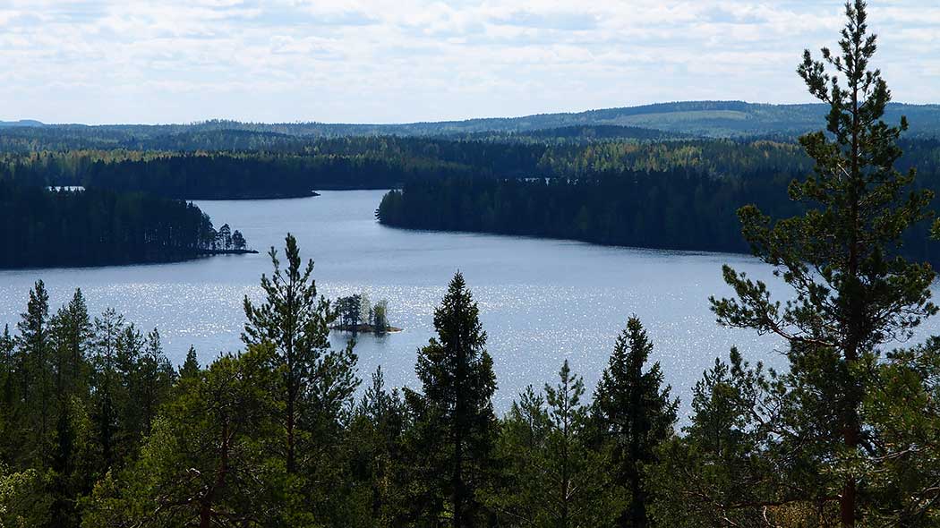
The hiking trail Three Mountains gives a taste of true wilderness. The rugged nature of Enonniemi features steep ascents and descents with spectacular views. The breathtakingly beautiful shores of Lake Konnevesi are ideal for a snack break or even an overnight stay.

Starting Point
The Kalaja parking area, Törmälän metsätie 136, Rautalampi, is 1 km from the starting point of the trail, the Vuori-Kalaja campfire shelter.
Hiking structures
Vuori-Kalaja campfire shelter, campfire site and toilet. Keskilahdi campfire site, canoe jetty and toilet. Enonranta campfire shelter, guest jetty with a canoe step and toilet. Please bring your own toilet paper. Midway on the trail, the Majaniemi rental hut and sauna (www.majaniemi.org, in Finnish) are available for visitors.


Sights
The picturesque shores of Lake Konnevesi, the old-growth forests of Enonniemi.
Route description
Trail marking: yellow paint mark
Recommended hiking direction: counter-clockwise

The 14 km Three Mountains hiking trail starts and ends at the Vuori-Kalaja campfire shelter. To get there, take the fairly easy gravel path (around 1 km) from the Kalajanvuori parking area. The total journey is approximately 16 km. The trail takes you to the rugged terrain of Kituvuori, Loukkuvuori and the Kalajanvuori hills in Enonniemi. If you wish, you can stop by the scenic lookout points of Loukkuvuori and Kalajanvuori to admire the views from the highest points of the national park.
Please note
- Reserve plenty of time for the hike, as the terrain is slow to walk in and there is a lot to see. You can count walking 2 kilometres per hour.


- If you get tired, you can take a shortcut straight to Enonranta, which shortens the trail with 2.2 kilometres.

Print out Print out the map (pdf 1.7 MB, julkaisut.metsa.fi).
Loukkuvuoren Lenkki (Loukkuvuori Hiking Trail), 2,8 km Circle Trail
When there is no ice and snow on the ground, the estimated travel time is 2 hours
A challenging trail, with large differences in altitude and rocky paths.
Loukkuvuoren lenkki trail offers hiking opportunity for boaters and paddlers. From the top of the hill Loukkuvuori you can enjoy the best view over the national park.

Starting Point
The Loukkuvuoren lenkki trail starts from the Enonranta campfire shelter, which is accessible by boat or canoe from Lake Konnevesi. The Loukkuvuoren lenkki route is also accessible by bicycle from the Loukkuvuori road. Barriers have been used to close the road off to cars.
Coordinates of Enonranta: Euref-Fin (~ WGS84) lat: 62° 34.8509' lon: 26° 39.0972' ETRS-TM35FIN N: 6938938 E: 482101


Hiking structures

On Enonranta there is a guest jetty with a canoe step, a campfire shelter and a toilet. Please bring your own toilet paper.
Sights
On the top of the Loukkuvuori hill, you feel like being on the rooftop of the national park.
Route description
Trail marking: yellow paint mark
Recommended hiking direction: counter-clockwise
The Loukkuvuoren lenkki trail runs along challenging terrain to the top of Loukkuvuori hill and back to the shore. The path is rocky and has large differences in altitude. Magnificent views over Lake Konnevesi open up from the hilltop.
Print Print out the map (pdf 1.7 MB, julkaisut.metsa.fi).


Boating Routes

An inland waterway across Southern Konnevesi runs east from Häyrylänranta in Konnevesi towards Konnekoski in Rautalampi. Routes diverging from this waterway include the one running northwards from Rääkänselkä to Närelahti, northwards from Mäkäräniemenselkä to Kivisalmi and southwards to Pitkäpohjanlahti. The waterway is 1.8 km deep. Proceed with caution outside the waterways, since plenty of shallows and underwater rocks appear at surprising locations in Southern Konnevesi. This waterway is challenging for inexperienced boaters.
Canoeing Routes

The national park and its surrounding areas have several canoeing routes of various lengths and degrees of difficulty (rautalampi.fi, in Finnish):
- Käpynän kierros route, 4,3 km / easy route
- Rajasaaren kierros route, 8 km / easy route
- Toussunlinnan kierros route, 18,5 km
- Haukisaaren kierros route, 8 km / easy route
- Silmutsaaren kierros route, 10 km / easy route
- Kivisalmen kierros route, 3 km / easy route
- Kartanokierros route, 10 km
- Kodanovisen melontareitti route, 19 km
- The Konnevesi rapids route, 22 km
The routes are maintained by the municipalities of Rautalampi (rautalampi.fi) and Konnevesi (konnevesi.fi, in Finnish).
Directions for canoeing routes

 When the wildfire warning is in effect, open fires are prohibited on every campfire site in Southern Konnevesi nationalpark. In Southern Konnevesi nationalpark this prohibition applies also to cooking shelters or other fireplaces with a flue. Check the current warnings (ilmatieteenlaitos.fi).
Southern Konnevesi Brochure

Trail Brochure


