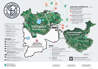
Vallisaari Directions and Maps
Vallisaari Brochure
Location
- Address of the islands: Vallisaari and Kuninkaansaari, FI-00860 Helsinki.
- Google Maps (google.fi)
- WGS 84 lat: 60.136678 lon: 25.009579
- Vallisaari and Kuninkaansaari are managed by Metsähallitus.
- Telephone: +358 20 639 4729
- E-mail: haltia(at)metsa.fi
Directions and Maps
Vallisaari and Kuninkaansaari are located in Helsinki, next to the Suomenlinna sea fortress, 20 minutes by boat from the Market Square. A water bus will take you to Vallisaari, from where you can walk over to Kuninkaansaari along a neck of land, much like a breakwater. Before visiting Vallisaari, please familiarise yourself with the rules and regulations that apply to the area.

By Water Bus
Water Bus traffic from Helsinki Market Square start 3.5.2024.
Water Bus timetable for summer 2024 (frs-finland.fi/vallisaari).
The water bus line to Vallisaari operates between Kauppatori and Vallisaari, with return trips as well. Passengers are left out from the water bus at the Pilotyard jetty on Vallisaari. Those with mobility restrictions or strollers can also choose to leave at the Torpedo pay jetty, where the water bus continues from Pilotyard. The return ferry to Kauppatori departs from the Torpedo pay jetty.
Tickets for the water bus can be purchased in advance from the online store (frs-finland.fi/vallisaari) and onboard the water bus.
By Own Boat
- The excursion harbour subject to a charge in Vallisaari is located in Torpedolahti bay. Overnight stays are permitted in the excursion harbour.
The excursion harbour and the Harbour café can be reached by telephone on +358 40 755 1130- Location: WGS 84 lat: 63.66727 lon: 25.01025
- Nautical charts series A and B; shoreline map 18; port map 191.
- Depth of fairway : 3 metres.
- Number of berths: 48.
- Buoy and boom mooring.
- Kayakers can land in the Torpedolahti excursion harbour or at the Vallisaari main jetty, in addition to the sandy coves located next to the Luotsitalo pilot house.
- The location of the Torpedolahti sand cove: WGS 84 lat: 60.13766 lon: 25.00998
- The location of the Luotsitalo sand cove: WGS 84 lat: 63.66727 lon: 25.00720
- Entering the restricted area in southern Vallisaari and landing there is prohibited under threat of penalty.
- PLEASE NOTE: Vallisaari will be open daily until 18 August and between 7 and 30 September. Between 19 August and 6 September, Vallisaari and its services will be closed on weekdays but open at the weekends of 24–25 August and 31 August–1 September. On the weekdays, excavation work will be carried out on the island, including the clearance of old explosives found in the soil. For safety reasons, landing on and accessing the island while this work is in progress will be prohibited.
By Taxi Boat
- Taxi boats are available by advance booking for small groups.
Maps
Printed Maps
- Helsinki Porkkala Jussarö waterproof boating chart, 1:50 000, Karttakeskus 2022.
- Porvoo Helsinki Loviisa waterproof boating chart, 1:50 000, Karttakeskus 2022.


