- Top Natural Attractions
-
National Parks
- Archipelago
- Bothnian Bay
- Bothnian Sea
- Ekenäs Archipelago
- Gulf of Finland
- Helvetinjärvi
- Hiidenportti
- Hossa
- Isojärvi
- Kauhaneva-Pohjankangas
- Koli
- Kolovesi
- Kurjenrahka
- Lauhanvuori
- Leivonmäki
- Lemmenjoki
- Liesjärvi
- Linnansaari
- Nuuksio
- Oulanka
- Pallas-Yllästunturi
- Patvinsuo
- Petkeljärvi
- Puurijärvi and Isosuo
- Pyhä-Häkki
- Pyhä-Luosto
- Päijänne
- Repovesi
- Riisitunturi
- Rokua
- Salla
- Salamajärvi
- Seitseminen
- Sipoonkorpi
- Southern Konnevesi
- Syöte
- Teijo
- Tiilikkajärvi
- Torronsuo
- Urho Kekkonen National Park
- Valkmusa
- World Heritage Sites
- National Hiking Areas
- Wilderness Areas
-
Other Nature Sites
- Aulanko
- Auttiköngäs
- Dagmar Park
- Friendship Park
- Hepoköngäs
- Hetta Area
- Hämeenkangas
- Iivaara
- Ilmakkiaapa
- Kairijoki
- Kevo
- Kivitunturi
- Korouoma
- Laajalahti
- Langinkoski
- Luiro Mires
- Malla
- Martimoaapa
- Meiko
- Neitvuori-Luonteri
- Näränkä
- Porkkala
- Punkaharju
- Rahja
- Sanginjoki
- Siikalahti Nature Reserve
- Simojärvi and Soppana
- Sompio
- Teuravuoma - Kivijärvenvuoma
- Valtavaara-Pyhävaara
- Viiankiaapa
- Ärjänsaari
- Öjen
- Uddskatan
- Hiking Trails
- Huts
-
Historical Sites
- Hunting Pits on Jyppyrä Hill
- Hytermä
- Kajaani Castle Ruins
- Kurjenpolvi Graveyard
- Kuusisto Bishop’s Castle Ruins
- Langinkoski Imperial Fishing Lodge
- Pakasaivo and the Kirkkopahta Seida Rock
- Rapola Hill Fort
- Raseborg Castle Ruin
- Seili Island
- Svartholma Sea Fortress
- The Grounds of Kaapin Jouni
- Vallisaari
- Äkässaivo and Seitapahta
- Örö Fortress Island
- Nature Centres
- Accessible Destinations
- Geoparks
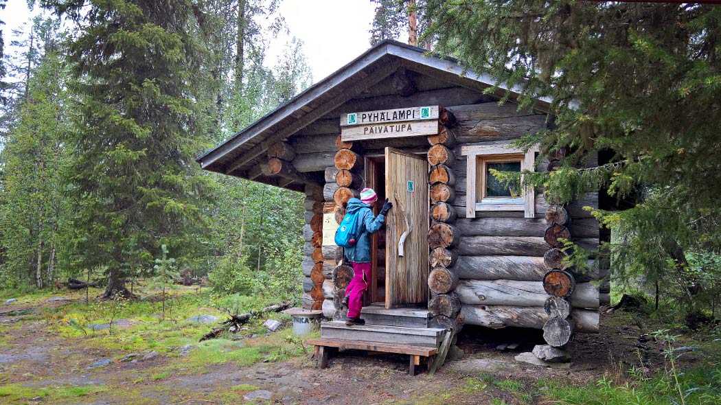
Pyhälampi Day-use Hut

Type
Location, Maps and Description
Eastern Lapland, Municipality of Pelkosenniemi, Pyhä-Luosto National Park
Pyhälampi, coordinates: Euref-Fin (~ WGS84) lat: 67° 05.7665' lon: 26° 57.1282' ETRS-TM35FIN: N: 7442094 E: 497921
The hut is situated between Latvavaara and Lampivaara Hills about 300 m east of Lake Pyhälampi on the north bank of the River Pyhäjoki along Pyhä-Luosto Hiking Trail. In winter a cross-country skiing trail goes next to the hut (open from week 8 onwards).
Pyhä Luosto tunturikartta, Pyhä-Luosto Fell Map, 1:25 000, Calazo 2018
Pyhä-Luosto ulkoilukartta, Pyhä-Luosto outdoor map, 1:25 000, Karttakeskus 2020
Facilities
- Heating: a wood stove
- Cooking: a wood stove and basic cooking pots. Bring your own tableware and utensils.
- Water: water can be taken year round from the River Pyhäjoki close to the hut (boil before use).
- Other facilities: in the yard there is a lean-to shelter, a woodshed and a dry toilet (bring your own toilet paper).
Notices
- Pets are permitted in the hut, but only in case that other visitors agree with it.
- Make sure you pack a first-aid kit.
- We recommend bringing a head torch.
- Safety on hiking
Waste Management
No waste management. Visitors are responsible of bringing their own waste out of the area. Read more about Hiking Without Littering.
Maintenance and Management
Metsähallitus, Parks & Wildlife Finland. For more information or feedback contact Pyhä-Luosto Visitor Centre Naava, tel. int. +358 206 39 7302.
Guidelines on using Day-use Huts
Outdoor Etiquette

1. Respect nature.
2. Mainly use marked trails.
3. Camp only where it is allowed.
4. Light your campfire only where it is allowed.
5. Do not litter.