- Top Natural Attractions
-
National Parks
- Archipelago
- Bothnian Bay
- Bothnian Sea
- Ekenäs Archipelago
- Gulf of Finland
- Helvetinjärvi
- Hiidenportti
- Hossa
- Isojärvi
- Kauhaneva-Pohjankangas
- Koli
- Kolovesi
- Kurjenrahka
- Lauhanvuori
- Leivonmäki
- Lemmenjoki
- Liesjärvi
- Linnansaari
- Nuuksio
- Oulanka
- Pallas-Yllästunturi
- Patvinsuo
- Petkeljärvi
- Puurijärvi and Isosuo
- Pyhä-Häkki
- Pyhä-Luosto
- Päijänne
- Repovesi
- Riisitunturi
- Rokua
- Salla
- Salamajärvi
- Seitseminen
- Sipoonkorpi
- Southern Konnevesi
- Syöte
- Teijo
- Tiilikkajärvi
- Torronsuo
- Urho Kekkonen National Park
- Valkmusa
- World Heritage Sites
- National Hiking Areas
- Wilderness Areas
-
Other Nature Sites
- Aulanko
- Auttiköngäs
- Dagmar Park
- Friendship Park
- Hepoköngäs
- Hetta Area
- Hämeenkangas
- Iivaara
- Ilmakkiaapa
- Kairijoki
- Kevo
- Kivitunturi
- Korouoma
- Laajalahti
- Langinkoski
- Luiro Mires
- Malla
- Martimoaapa
- Meiko
- Neitvuori-Luonteri
- Näränkä
- Porkkala
- Punkaharju
- Rahja
- Sanginjoki
- Siikalahti Nature Reserve
- Simojärvi and Soppana
- Sompio
- Teuravuoma - Kivijärvenvuoma
- Valtavaara-Pyhävaara
- Viiankiaapa
- Ärjänsaari
- Öjen
- Uddskatan
- Hiking Trails
- Huts
-
Historical Sites
- Hunting Pits on Jyppyrä Hill
- Hytermä
- Kajaani Castle Ruins
- Kurjenpolvi Graveyard
- Kuusisto Bishop’s Castle Ruins
- Langinkoski Imperial Fishing Lodge
- Pakasaivo and the Kirkkopahta Seida Rock
- Rapola Hill Fort
- Raseborg Castle Ruin
- Seili Island
- Svartholma Sea Fortress
- The Grounds of Kaapin Jouni
- Vallisaari
- Äkässaivo and Seitapahta
- Örö Fortress Island
- Nature Centres
- Accessible Destinations
- Geoparks
Aalistunturi Day-use Hut


Location, Maps and Description
Western Lapland Region, Municipality of Kolari (kolari.fi, in Finnish), Kolari public land, Pasmajärvi
Aalistunturi, coordinates: Euref-Fin (~ WGS84) lat: 67° 01.3799' lon: 24° 25.8877' ETRS-TM35FIN: N: 7436252 E: 388137
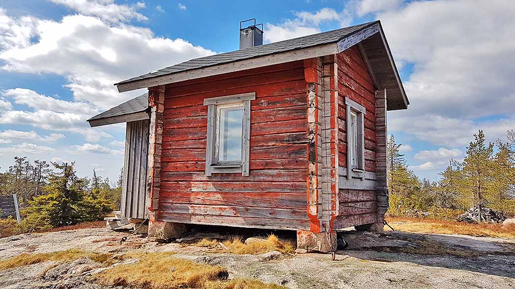
Aalistunturi Day-use Hut, the former fire guard hut, is located on top of Aalistunturi Fell in the municipality of Kolari. You can get to Aalistunturi by taking a logging road that starts from Aalisjärventie, the road connecting the villages of Pasmajärvi and Konttajärvi.
Facilities
A stove, a dry toilet and a woodshed.
Notices
Pets are allowed in the hut, but only in case that other visitors agree with it.
Visitors must come prepared with warm clothing, food, drink, maps, a compass, orienteering skills and matches. Fog or storms can form within just a few hours. Bring also your own toilet paper.
Waste Management
Parks & Wildlife Finland follows the leave no trace principles, and hikers are adviced to bring their own waste out of the area. Read more about Hiking Without Littering.
Maintenance and Management
The hut is owned by Metsähallitus, Parks & Wildlife Finland, and the maintenance is operated by the volunteers of Pasmajärvi village association. For more information contact Yllästunturi Visitor Centre Kellokas, tel. int. +358 206 39 7039.
Guidelines on using Open Wilderness Hut

Guidelines on using Day-use Huts
Outdoor Etiquette

1. Respect nature.
2. Mainly use marked trails.
3. Camp only where it is allowed.
4. Light your campfire only where it is allowed.
5. Do not litter.