- Top Natural Attractions
-
National Parks
- Archipelago
- Bothnian Bay
- Bothnian Sea
- Ekenäs Archipelago
- Gulf of Finland
- Helvetinjärvi
- Hiidenportti
- Hossa
- Isojärvi
- Kauhaneva-Pohjankangas
- Koli
- Kolovesi
- Kurjenrahka
- Lauhanvuori
- Leivonmäki
- Lemmenjoki
- Liesjärvi
- Linnansaari
- Nuuksio
- Oulanka
- Pallas-Yllästunturi
- Patvinsuo
- Petkeljärvi
- Puurijärvi and Isosuo
- Pyhä-Häkki
- Pyhä-Luosto
- Päijänne
- Repovesi
- Riisitunturi
- Rokua
- Salla
- Salamajärvi
- Seitseminen
- Sipoonkorpi
- Southern Konnevesi
- Syöte
- Teijo
- Tiilikkajärvi
- Torronsuo
- Urho Kekkonen National Park
- Valkmusa
- World Heritage Sites
- National Hiking Areas
- Wilderness Areas
-
Other Nature Sites
- Aulanko
- Auttiköngäs
- Dagmar Park
- Friendship Park
- Hepoköngäs
- Hetta Area
- Hämeenkangas
- Iivaara
- Ilmakkiaapa
- Kairijoki
- Kevo
- Kivitunturi
- Korouoma
- Laajalahti
- Langinkoski
- Luiro Mires
- Malla
- Martimoaapa
- Meiko
- Neitvuori-Luonteri
- Näränkä
- Porkkala
- Punkaharju
- Rahja
- Sanginjoki
- Siikalahti Nature Reserve
- Simojärvi and Soppana
- Sompio
- Teuravuoma - Kivijärvenvuoma
- Valtavaara-Pyhävaara
- Viiankiaapa
- Ärjänsaari
- Öjen
- Uddskatan
- Hiking Trails
- Huts
-
Historical Sites
- Hunting Pits on Jyppyrä Hill
- Hytermä
- Kajaani Castle Ruins
- Kurjenpolvi Graveyard
- Kuusisto Bishop’s Castle Ruins
- Langinkoski Imperial Fishing Lodge
- Pakasaivo and the Kirkkopahta Seida Rock
- Rapola Hill Fort
- Raseborg Castle Ruin
- Seili Island
- Svartholma Sea Fortress
- The Grounds of Kaapin Jouni
- Vallisaari
- Äkässaivo and Seitapahta
- Örö Fortress Island
- Nature Centres
- Accessible Destinations
- Geoparks
Valtavaara Day-use Hut
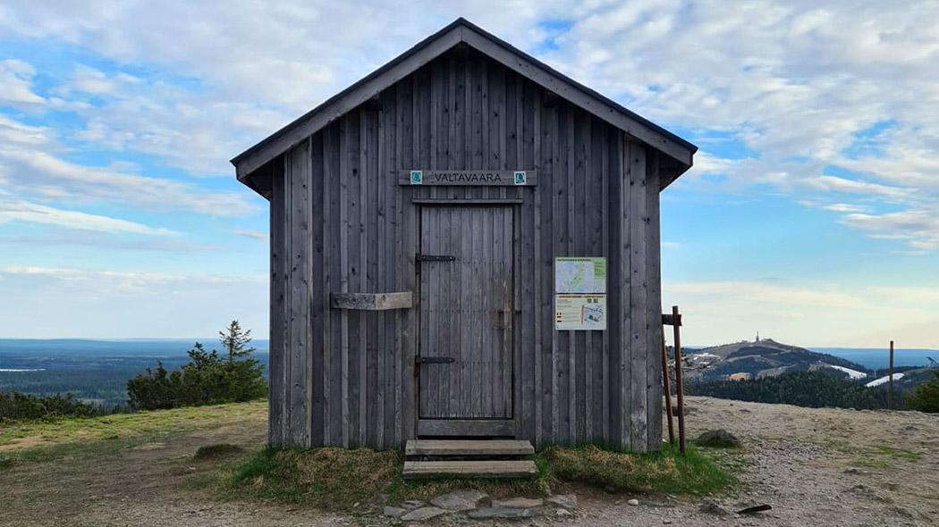


This hut was originally a fire guard's hut. It is situated on Valtavaara, the highest hill in Kuusamo. It is on Karhunkierros Trail, 4 km from Rukatunturi Fell, and by the Valtavaara Ski Trail.
Type
Location
North Ostrobothnia, Municipality of Kuusamo, Valtavaara Nature Reserve and Karhunkierros Hiking Trail.
Maps
- Excursionmap.fi
- Karhunkierros Hiking Trail maps
- Rukatunturi-Oulanka outdoor map 1:50,000
Coordinates
Valtavaara, coordinates: Euref-Fin (~ WGS84) lat: 66° 11.2080' lon: 29° 11.5117' ETRS-TM35FIN: N: 7342459 E: 598736
Facilities
- The nearest dry toilet is located in 300 meters from the hut, down the slope at Valtavaara campfire shelter ("Valtavaaran kota").
- No stove. The stove was removed in January 2020 to protect the historically valuable hut.
Waste Management
No trash bins. Please do not leave any litter or other traces of your stay. Read more about Hiking Without Littering.
Notices
- Pets are allowed in the hut.
- Safety on hiking
Maintenance and Management
Metsähallitus, Parks & Wildlife Finland.
For more information contact
Oulanka Visitor Centre tel. int. +358 206 39 6850
Guidelines on using Day-use Huts

Information for Companies and Big Groups
Do you plan to organize guided excursions to the Finnish National Parks or other protected areas? It is possible due to partnership agreement with Metsähallitus, Parks & Wildlife Finland.
- Sustainable Tourism in Protected areas in Finland (julkaisut.metsa.fi)
- Please, contact kirjaamo(at)metsa.fi
Overnighting
Many kinds of Huts for the Hiker. Please note, that it is not allowed for big groups or commercial groups to overnight in Open Wilderness Huts and in Day-use Huts.

Excursionmap.fi is a free map service provided by Metsähallitus. It can be used to search destinations, choose map layers and print maps.
Outdoor Etiquette

1. Respect nature.
2. Mainly use marked trails.
3. Camp only where it is allowed.
4. Light your campfire only where it is allowed.
5. Do not litter.