
Hiking Trails
There are nature trails and several longer hiking trails in the Hetta Area.
Starting Points for Trails
- There are two starting points for hiking and ski trails on the north side of Hetta. They are Fell Lapland Visitor Centre and behind the Enontekiö centre school buildings.
- Visitors heading towards Pallas-Yllästunturi National Park must first cross Lake Ounasjärvi. Private tourist services provide boat trips across the lake. You should ask the service provider for the exact location of the boat stage.
- Starting points for the cross-country skiing trails which enter the National Park are behind the municipality offices at the fishing harbour and at Paavontalo House at the east end of the village of Hetta.
Nature Trails
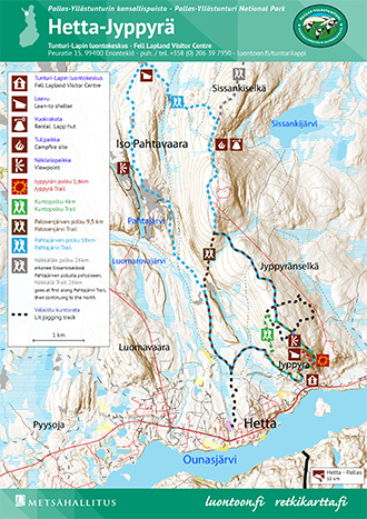
- The Jyppyrä Trail, 1.6 km, starts from the outside of Fell Lapland Visitor Centre and goes to the lookout point located on the top of Jyppyrävaara Hill. The trail has been marked with red-painted sun symbols. The stairs along the trail have been removed. The information boards along the trail tell you about the area's history: the customs of the Midsummer celebration and the seida rocks. The Jyppyrä Trail belongs to the trail network of the Hetta Area (pdf 0.7 Mb, julkaisut.metsa.fi).
- Services: A look-out campfire shelter on the top of Jyppyrä Hill.
- Peurapolku Trail, 2 km, features wild reindeer hunting. The trail has its starting point at Fell Lapland Visitor Centre. The trail leads across easy terrain on the south side of Jyppyrä Hill. The following trails go via the Peurapolku Trail: Kuntopolku Trail and the Palosenjärvi and Pahtajärvi Trails. There are several old hole traps, game running fences and boards with information on hunting along the trail. The trail is marked with poles with hoof prints on them.
Other Trails
- The Kuntopolku Trail, 4 km, starts from the Fell Lapland Visitor Centre yard between the two buildings. The trail has been marked with green marks. The first part of the trail goes along the same route as the path that leads to the top of Jyppyrä Hill. The trail goes around the hilltop from the eastern side, and at the midway point it joins with the lit jogging track. The trail returns to the visitor centre along the same route as the Peurapolku Trail.
- The Palosenjärvi Trail, 9.5 km, starts from the Fell Lapland Visitor Centre yard between the two buildings. The trail has been marked with brown marks. It circles around the Jyppyrävaara hilltop from the eastern side and goes across the upper circle of the lit jogging track and continues across Jyppyränselkä. On the slope of the Paljasselkä Fell, the trail branches off from the Pahtajärvi Trail and turns south towards the centre of Hetta. Lake Palosenjärvi remains on the eastern side of the trail. At the point where the trail meets the lit jogging track, it turns to the northeast. You can return to Skierri along the Peurapolku Trail. The entire trail has been marked with brown marks.
- The Pahtajärvi Trail, 18 km, starts from the Fell Lapland Visitor Centre yard between the two buildings along the same route as the Kuntopolku, Palosenjärvi and Näkkälä Trails. The Pahtajärvi Trail has been marked with blue marks. The trail continues on Jyppyrä Hill across the lit jogging track towards the Paljasselkä Fell. At Sissanginselkä the Pahtajärvi Trail turns west and the trail to Näkkälä continues to the north. After the Närpistönjoki lean-to shelter, the Pahtajärvi Trail turns south towards Pahtajärvi.
The most rugged landscape along the trail is at Lake Pahtajärvi, where the lake is down in a canyon and the trail leads along the upper slopes on its east side. There are beautiful wetlands along the trail, where an abundance of Globe Flowers (Trollius europaeus) and the Wood Crane's-bills (Geranium sylvaticum) grow.
Just before the village of Hetta, the Pahtajärvi Trail joins the lit jogging track along which you may return to the visitor centre. The last kilometre of the trail goes along the Peurapolku Trail.
There are information boards or signposts in the branches of the Pahtajärvi trail. There are duckboards on the trail but despite that you will need waterproof hiking boots.- Services: Sissanki rental hut, which is located between Sissanginselkä and Paljässelkä. The hut can be rented for overnight stays otherwise it is locked. Närpistö lean-to shelter is located at the trail's halfway point.
- Sights: Lake Pahtajärvi, a long and narrow canyon lake.
- Hetta-Näkkälä Trail, 26 km. This trail leads from the village of Hetta to the village of Näkkälä.
- Hetta - Pallas Trail, 55 km. This is a summer hiking trail which is within Pallas-Yllästunturi National Park. Hikers must first cross Lake Ounasjärvi by a local boat service.
Cross-country Skiing Trails
During spring there are numerous ski trails (enontekiolapland.com) open in the Hetta Area. During early winter only a lit trail is kept open. As soon as there is a sufficient amount of snow a ski trail to Pyhäkero is opened as well. All the area's trails are usually open by the middle of February.
There is always a certain amount of risk when skiing in fell areas and skiers should be aware of and prepared for them. The wind can be bitingly cold and the trail is covered easily during harsh bursts of wind. You should never go skiing in fell areas without proper gear. Ski trail maps are available at Fell Lapland Visitor Centre or they can be printed from the Tosilappi website (enontekiolapland.com).
- Lit Skiing Trail, 10 km. A lit skiing trail circles around Jyppyrävaara Hill and it could be called "the first snow trail" as it is opened to the public when the first permanent snow falls in October-November. The trail is moderately demanding and it is suited for both classical and free-style cross-country skiing. When the days get shorter the lights along the trail light up at twilight and switch off at 10 pm.
The starting point for the lit trail is behind the school buildings. The ski trail climbs to the top of a hill and there skiers can find a 3,3 km loop trail which should be skied counter-clockwise. The trail is maintained by the municipality of Enontekiö.
A connecting trail from the lit trail leads to Fell Lapland Visitor Centre. This connecting trail is opened normally during late winter. The connecting trail also leads to the Hetta Ski Centre that is being built on Jyppyrä. - Pahtajärvi Skiing Trail, about 18 km. The simplest place to set off on this trail is along a lit trail from behind the school buildings. Pahtajärvi Trail turns off this lit trail after about 1,6 km. The beginning parts of the trail are classified as moderately demanding, but when approaching Närpistö lean-to shelter the terrain becomes level and the final part of the trail is easy to travel. The trail continues near some dwelling houses along the River Närpistöjoki and its bank to Lake Ounasjärvi.
Pahtajärvi skiing trail is suited for both classic and free-style cross-country skiing, although it is considered by most as a classic cross-country trail. Skiers may ski in either direction along the trail. The fastest descents along the trail are on both sides of Sissanki rental hut (Sissangin kota). After snowfall the trail is usually opened after maintaining the Pyhäkero, Sioskuru and Onnasvaara ski trails. The trail is maintained by Ounaksen Tunturiladut Oy.
Skiers can also get onto the trail at Fell Lapland Visitor Centre. In this case it is advisable to ski via Paljasselkä to Närpistö lean-to shelter and from there via Lake Pahtajärvi to Hetta.- Services: Sissanki rental hut which is located between Sissanginselkä and Paljasselkä. The hut can be rented for overnight stays otherwise it is locked. Närpistö lean-to shelter is located at the trail's halfway point.
- Sights: Lake Pahtajärvi, a long and narrow ravine lake.
- Hetta-Pyhäkero Skiing Trail, about 7 km. There are several ski trails which go to Pyhäkero open wilderness hut, which is in Pallas-Yllästunturi National Park. All these trails cross Lake Ounasjärvi. The easiest trails are the most eastern trail which starts from Paavontalo House or Hetan Kota and the most western trail, which also starts in the centre of Hetta. The middle trail is classified as moderately demanding.
The skiing trails are suited for both classical and free-style cross-country skiing and have separate tracks for each direction. Skiers can ski the trails in either direction. Because all the area's ski trails return via Lake Ounasjärvi to Hetta Village it is possible to return along a different ski trail than the one you left by. After snowfall the trails between Hetta and Pyhäkero are maintained and opened first. The trail is maintained by Ounaksen Tunturiladut Oy.- Services: Pyhäkero open wilderness hut and Pyhäkero Café. The café is open during peak season.
- Hetta - Pyhäkero - Sioskuru Skiing Trail, about 15 km. Skiers can reach Sioskuru Ravine in Pallas-Yllästunturi National Park by first skiing to Pyhäkero open wilderness hut, which can be reached from different spots around the village of Hetta. From Pyhäkero the ski trail continues through sparse pine forest until you arrive at the long and narrow Koivukuru Ravine. In the ravine you should watch out for skiers heading in the opposite direction. After exiting the ravine there is a treeless hill top. At the trails halfway point is a crossroads from where a ski trail to Sammalvaara parts from the main trail. After the crossroads the ski trail begins a slow descent towards Sioskuru Ravine, where skiers can find rest at Sioskuru open and reservable wilderness hut.
After snowfall the ski trail leading from Pyhäkero Fell to Sioskuru Ravine is usually on the maintenance list straight after the Hetta-Pyhäkero ski trails. The Sioskuru trail has separate tracks for each direction and it is suited for classic and free-style cross-country skiing. From Pyhäkero onward the trail is classified as moderately demanding. The trail is maintained by Ounaksen Tunturiladut Oy.- Services: Pyhäkero open wilderness hut and Pyhäkero Café, Sioskuru open and reservable hut.
- Ullajärvi Skiing Trail, about 20 km. Skiers can get onto this trail if they first follow the most eastern trail from Ounasjärvi to Pyhäkero. When the trail reaches behind Lake Ounasjärvi Ullajärvi trail turns left off of it. The trail first leads near Lake Ullanjärvi and then joins Onnasvaara trail about 2,5 km before Pyhäkero wilderness hut. From the crossroads skiers can also go via the Onnasvaara Hills towards Sioskuru Ravine. If skiers choose this trail the routes length is 39 km.
The only part of the ski trail that is demanding the portion between Pyhäkero and Onnasvaara. Otherwise the trail is classified as easy.
Ullajärvi Skiing Trail is a wilderness ski trail and is one of the last to be opened after snowfall. There is no free-style cross country track on the portion that leads through wilderness, but it is still possible at points. Skiers can follow the trail in either direction. The trail is maintained by Ounaksen Tunturiladut Oy.- Services: Pyhäkero open wilderness hut and Pyhäkero Café
- Sammalvaara Skiing Trail, about 30 km. Skiers may ski this trail in either direction. Skiers can first ski from Hetta to Pyhäkero and on towards Sioskuru Ravine until Sammalvaara trail parts from the trail leading all the way to Sioskuru. Skiers who set off from Hetta can get on the trail by first skiing along the most western trail leading to Pyhäkero. Sammalvaara trail turns off this trail. For the most part the trail travels through easy to cross terrain. If skiing from the Hetta direction there is, however, one fast descent before Postitupajärvi lean-to shelter.
Sammalvaara trail is a wilderness ski trail which is last on the maintenance list after heavy snowfall. The trail is maintained by Ounaksen Tunturiladut Oy.- Services: Pyhäkero open wilderness hut and Pyhäkero Café, Postitupajärvi lean-to shelter and Rautujärvi campfire site.
- Onnasvaara Skiing Trail, about 38 km. From Hetta skiers head to Pyhäkero open wilderness hut, from where they turn left. Onnasvaara trail circles around Pyhäkero via Onnasvaara Hills and then returns via Sioskuru Ravine to Hetta.
Visitors should follow the ski trail in a clock-wise direction. From Pyhäkero to Savilampi campfire shelter the ski trail is demanding. Some descents along the trail are steep and have many turns. When coming to hills watch out for skiers heading in the opposite direction. From the campfire shelter to Sioskuru Ravine the terrain is not demanding to cross.
The ski trail is suited for classic cross-country as well as free-style cross-country. This ski trail is the third to get maintained and restored after snowfall after the Pyhäkero and Sioskuru skiing trails. It is maintained by Ounaksen Tunturiladut Oy.- Services: Pyhäkero open wilderness hut and Pyhäkero Café, Savilampi campfire shelter and Sioskuru open and reservable wilderness hut.
Boating and Canoeing Routes
- The River Ounasjoki is 300 km long and its source is Lake Ounasjärvi. It is the longest river which is completely within Finland's borders and flows freely. It is an interesting destination for long distance canoeists. Round rocks that have been shaped by moving ice and water are characteristic of the river. These rocks are difficult to spot from upstream. The rapids along the river vary in classification from I to III. The most difficult rapids along the route are Kurkkio, Köngäs and Molkoköngäs.

If you want to canoe down the entire river from Hetta all the way to Rovaniemi, you should take into account that the trip will take at least 2 weeks. There are 30 sets of rapids along the route and altogether this equals to a drop of 200 metres. There are villages by the river, but also long stretches which are uninhabited. From Ketomella to Rovaniemi a road runs by the river.
The starting point for the canoeing route is at the east end of Lake Ounasjärvi, which is 5 km from the centre of Hetta across water. The first rapids are the 400 m long Periläkoski which is shallow and rocky. After these rapids you will arrive at Lake Perilänjärvi, at the east end of which the River Näkkäläjoki flows into the River Ounasjoki. A few kilometres after this the river widens and becomes the quiet waters of Joentekiäinen pool. At this point the River Vanhajoki flows into the River Ounasjoki. From Joentekiäinen the River Ounasjoki continues southward.
You can also go fishing on your canoeing trip but fishers need to check what kind of permits they need to purchase in advance. As different parts of the river Ounasjoki are owned either by the state or different shareholder associations, it is divided into several permit areas. The portion of the river which is covered by a single permit starts only after Lake Ounasjärvi once the river crosses into the municipality of Kittilä.- Services in the municipality of Enontekiö: A lean-to shelter on the shore of Lake Periläjärvi, which is managed by Enontekiö, a campfire site and Sioskoski day-use hut before the village of Ketomella.

Biking Trails
- National biking trail 21 runs through the village of Hetta in an east-west direction. The trail that comes from the south leads from Keminmaa via Kolari and Äkäslompolo to Muonio and from there to Palojoensuu. From Palojoensuu bikers can turn towards Hetta or to Kilpisjärvi.
In Hetta village the biking trail leads along marked biking routes and continues eastward via Peltovuoma Village to Raattama. The biking trail is marked with brown and white bicycle signs.- Services: Lodging services and shops can be found near villages. Within the municipality of Enontekiö there are shops in the villages of Hetta and Kilpisjärvi.
- From Hetta it is possible to cycle to the village of Näkkälä. The route is 26 km long. The route is marked and is considered very demanding.
- Mountain biking in Pallas-Yllästunturi National park
- More information on mountain biking in Enontekiö
Snowmobile Routes and Tracks
From the Hetta Area it is possible to snowmobile in various directions along snowmobile routes. The easiest way to set off on a route is to go to Lake Ounasjärvi. There is a track crossing the lake from east to west. From this track you can continue south to Muonio and Pyhäkero open wilderness hut. Heading east by snowmobile you can ride to Kittilä via Vuontisjärvi, Peltovuoma and Nunnanen or turn just before Vuontisjärvi towards Raattama. The snowmobile track heading west from Hetta leads via Palojoensuu to Kilpisjärvi. If you choose to go north there are two different track options. These meet at Lake Palojärvi. From Palojärvi the joined track leads all the way to Kilpisjärvi.
If you snowmobile along snowmobile tracks within the Hetta Area no permit is needed. The tracks in the area are maintained by the municipality of Enontekiö (enontekio.fi, in Finnish). The tracks have not yet been officially inspected so riding along them at your own risk.
Visitors who are planning on snowmobiling from Hetta across wilderness areas to Kilpisjärvi must purchase a Metsähallitus snowmobile permit, as the track between Palojärvi and Kilpisjärvi is maintained by Metsähallitus and funded by permits.
Hetta–Jyppyrä Area
Trail Map

Snowmobiling - Licences for snowmobile tracks maintained by Metsähallitus
