Kolovesi National Park Directions and Maps
Directions
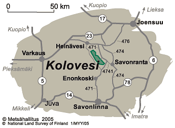
Kolovesi National Park is located south of the main road no 23.
By Car
- It is about 15 km from the municipality of Enonkoski to the boat launching place of Käkövesi, where there is an information board with a map. The way is signposted from the centre of Enonkoski, from where you need to continue in the road no 471 to the ferry over Hanhivirta and onto the fork of the road going to Käkövesi boat launching place, where there is a brown and white sign to Kolovesi National Park Käkövesi. There is a parking area at Käkövesi boat launching place. Parking area is not ploughed in winter.
- When going to Nahkiaissalo Nature Trail, you need to drive the road 471 further. There is a brown and white sign to Kolovesi National Park Nahkiaissalo at the fork to Selkälahti of the road no 471. More information can be found at the starting points for trails. There is a parking area at the starting point of the Nahkiassalo Nature Trail on the road going to Selkälahti. Selkälahti road and parking area are not ploughed in winter.
- Kirkkoranta boat launching place is located 22 km north of Enonkoski. Drive the road no 471. After the fork to Nahkiassalo continue 6 km the road 471 onwards. There is a sign to Kolovesi National Park Kirkkoranta in the fork to Kirkkoranta. In the end of the road on the shore of Kolovesi there is a parking area. The road leading to Kirkkoranta and the parking area there are not ploughed in winter.
For more detailed parking area addresses, please see below under Starting Points for Excursions.
Note! Google Maps has a wrong address and leads to a wrong place. The correct address to the main entrance is Kirkkorannantie 200, 58180 Enonkoski.
By Boat Transportation
- Read more about Services for Boaters.
By Public Transportation
It is about 33 km to Enonkoski from Savonlinna, and about 55 km from Heinävesi. From Enonkoski it is about 15 km to Käkövesi boat launching place and about 22 km to Kirkkoranta boat launching place. It is about 55 km to Savonranta from Savonlinna. From Savonranta it is about 25 km to Käkövesi boat launching place and 21 km to Kirkkoranta boat launching place.
- The nearest coach services (matkahuolto.fi) are to Enonkoski and to Savonranta on weekdays from Savonlinna or Joensuu (Heinävesi) direction.
- The railway station closest to the national park is in Vihtari, and it can be reached every day by train from South (Helsinki) and North (Joensuu).
- The best way to reach National Park Kolovesi from bus or train station is by taxi.
- There are no services in Kirkkoranta. Read more about enterprises and organisations offering services in the national park.
- There are also train (vr.fi) and flight (finavia.fi) connections to Savonlinna.
Starting Points for Excursions
- Starting points for Nature Trails.
- The boat launching place is at Käkövesi (Vääräntauksentie, Enonkoski) and Kirkkoranta (Kirkkorannantie, Enonkoski). More precise parking area addresses are not available.
Maps
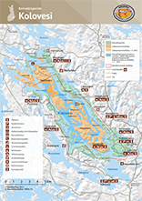
- Kolovesi brochure map (Pdf-file 4.4 Mb, julkaisut.metsa.fi)
- Excursionmap.fi of Metsähallitus
- National Land Survey of Finland map service (karttapaikka.fi)
Other Maps
- Terrain maps N514 and N532, 1:50 000. Maps are sold by Karttakeskus, the National Land Survey of Finland and well-stocked bookstores.
- Vesiretkeilykartasto: Canoe route map - Keskinen Saimaa (Linnansaari National Park, Haapaselkä, Joutenvesi, Kolovesi National Park, Kermajärvi) 1:50 000. Maps can be bought at Saimaa Nature Centre Riihisaari customer service point in Savonlinna Provincial Museum.
- Merikartta M Saimaan vesistö, Savonlinna - Kuopio: Nautical chart M Saimaa lake system, Savonlinna - Kuopio, 1:40 000. Maps are sold by Karttakeskus.
- Yleismerikartta 921, Saimaan vesistö: General nautical chart 921, Saimaa lake system, 1:200 000, 2001. Maps are sold by Karttakeskus.
- Maastokartat: Terrain maps nos 4212 05, 4212 06 and 4212 08, 1:20 000. Maps are sold by Karttakeskus, the National Land Survey of Finland and well-stocked bookstores.
- Retkeily GT Itä-Suomi: GT Outdoor map Finland East, 2014, 1:250 000. The maps are sold by Karttakeskus and well-stocked bookstores.
Map Sales Points
Parking Areas
Selkälahti (Nature Trail)
- Selkälahdentie, Savonlinna
Käkövesi
- Vääräntauksentie, Enonkoski
Kirkkoranta
- Kirkkorannantie, Enonkoski
More precise parking area addresses are not available. Parking area addresses are in Finnish to be used in navigators.