


Huippujen kierros Trail (Trail of the Tops), 1.4 km Circle Trail
Dive into the landscape and join centuries of Koli visitors. The classic trail culminating at the top of Ukko-Koli reveals its various landscapes as it winds round the tops of Akka-Koli and Paha-Koli.
Available: In the snow-free season. The trail does not have winter maintenance, but as it is a popular trail all year round, the path is often clear also in the winter.
Travel time: 30 min–1 h.
Difficulty: The trail is intermediate due to differences in height, steep stairs and slippery bare rock. The trail also has step-free access for prams and wheelchairs to a demanding accessible viewpoint, but due to large differences in altitude an assistant is needed. Read more Ukko-Koli demanding accessible Trail, 400 m each way.
Starting Point
Address: Koli Nature Centre Ukko's Upper Yard (Yläpiha), Ylä-Kolintie 39, Koli, Lieksa.
The nearest parking areas to the starting point are P1, P2 and P3 at Ylä-Koli, address Ylä-Kolintie 31, Koli, Lieksa. From the parking areas, you can access Upper Yard on foot or by the free funicular.
Please note that the parking areas in Ylä-Koli are easily congested.
 Before starting your trip, please read the instructions for arriving at Koli.
Huippujen kierros Trail brochure (pdf 883 kb, julkaisut.metsa.fi).
Huippujen kierros Trail in Excursionmap.fi.
Sights
The iconic landscape opening from Ukko-Koli to the east across Pielinen, the rugged and charismatic Paha-Koli and its stories, and the western views of Akka-Koli and with its impressive sunsets.
Services
At the starting point, the services of the Upper Yard, such as the hotel restaurant and Koli Nature Centre Ukko, with stores, cafés and exhibitions.
Please note that there is no toilet along the short route, but an indoor toilet can be found in Koli Nature Centre Ukko and Break Sokos Hotel Koli.
Hiking Structures
Along the trail there are steep stairs and short duckboards.
The Prime Minister's campfire site is located in the immediate vicinity of Koli Nature Centre Ukko. There is no firewood maintenance at this campfire site, so you can bring your own firewood or buy firewood from Koli Nature Centre Ukko or Break Sokos Hotel Koli.
Trail Description
The trail is marked with yellow circles on signposts at trail junctions. The signposts have been numbered and the numbers correspond to the numbering of the Koli service and trail map (1:20,000) (koli.fi, in Finnish). Recommended direction is counterclockwise.
The trail starts at Upper Yard, junction 65. The trail dives into the forest from junction 11 behind the Koli Nature Centre Ukko, and heads towards Akka-Koli to the right through junction 12. The landscape of Akka-Koli is already visible from the rocky plateau on the right side of the trail, but you can also continue up and to the left from junction 70 to reach the highest point of Akka-Koli.
After Akka-Koli there is bare rock, short duckboards and small stairs through junctions 69 and 68 towards Paha-Koli. If you don't want to climb to Paha-Koli's steep slope, you'll find a small scenic viewpoint shaped by nature, where you can sense the atmosphere of Paha-Koli.
From Paha-Koli, the trail turns back past several intersections towards Ukko-Koli. If you want to enjoy the views of Ukko-Koli without climbing the stairs to the top, you can turn right at junction 66, which takes you to a demanding accessible viewpoint.
You can return to the start point of the trail by continuing forward and eventually descending steep stairs to the Upper Yard. Step-free access back to the Upper Yard is available by returning through junction 13.
Please Note
Koli's peaks and many other scenic viewpoints have a rough terrain and the bare rock areas are particularly slippery when it rains. There are no handrails at the viewpoints. They are natural attractions where visitors go at their own risk. Visitors must leave the hilltop during a thunderstorm.
The steep steps down to junction 65 are not passable in winter. See the Ukko-Koli winter Trail, 400 m each way.

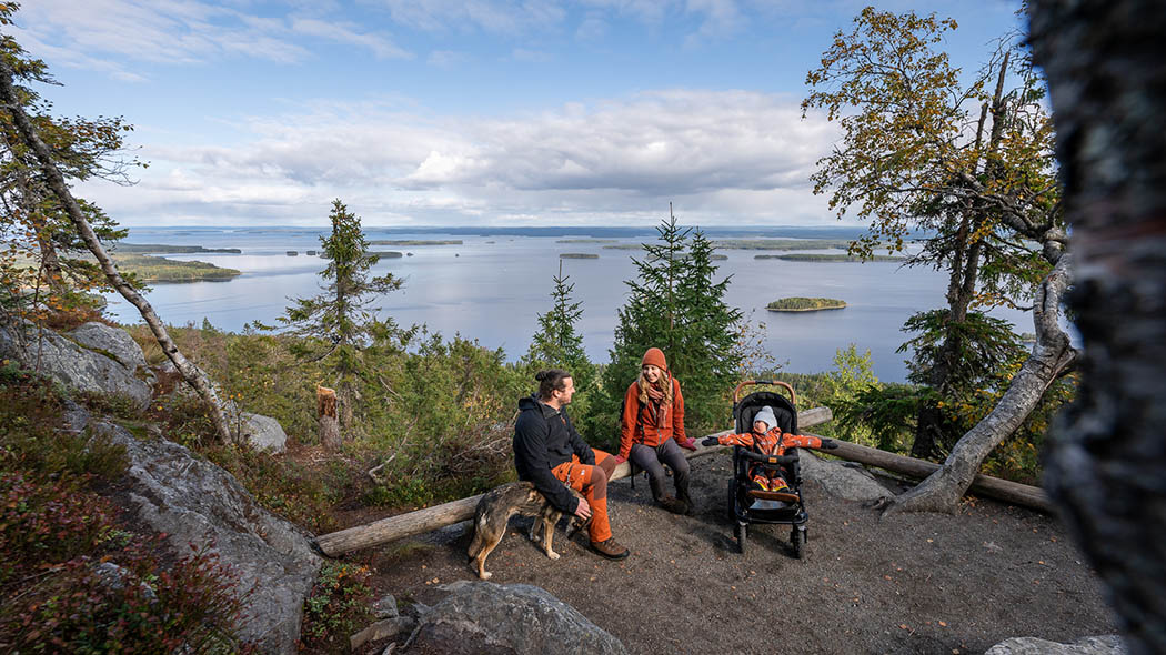


Ukko-Koli demanding accessible Trail, 400 m each way

The Ukko-Koli demanding accessible Trail rewards travellers with spectacular views after a hard climb. At the demanding accessible viewpoint you can almost feel like you’re floating between Earth and the sky.
Available: In the snow-free season.
Travel time: 30 min.
Difficulty: Demanding accessible trail. The gravel trail does not have any stairs but the altitude differences are significant so wheelchair users should have an assistant with them. The trail has lateral slopes, roots and rainwater ruts that can make the trail more challenging for those using mobility aids.
Starting Point
Address: Koli Nature Centre Ukko's Upper Yard (Yläpiha), Ylä-Kolintie 39, Koli, Lieksa.
There are two reserved accessible parking spaces in the Upper Yard.
The lower level at Ylä-Koli has three more parking areas: P1, P2 and P3, address Ylä-Kolintie 31, Koli, Lieksa. You can access Upper Yard from the lower parking areas by stairs with a railing or by the free and accessible funicular.
Please note that the parking areas in Ylä-Koli are easily congested.
Before starting your trip, please read the instructions for arriving at Koli.
The Ukko-Koli demanding accessible Trail brochure (pdf 862 kb, julkaisut.metsa.fi).
The Ukko-Koli demanding accessible Trail in Excursionmap.fi.
Sights
Koli’s classic landscape panorama towards Pielinen, fairytale fell forests, accessible Prime Minister's campfire site.
Services
At the starting point, the services of the Upper Yard, such as the hotel restaurant and Koli Nature Centre Ukko, with stores, cafés and exhibitions.
The whole Koli Nature Centre Ukko is accessible. The building has an accessible toilet, ramps to exhibitions and a lift upstairs. The Vaarasali auditorium also has an induction loop for the hearing impaired. The lower level of the auditorium is accessible.
Hiking Structures
The Prime Minister's campfire site is located in the immediate vicinity of Koli Nature Centre Ukko. The route to the campfire site is accessible. Please note that the table at the site is not accessible as the benches by the table are fixed. There is no firewood maintenance at this campfire site, so you can bring your own firewood or buy firewood at the Koli Nature Centre Ukko or Break Sokos Hotel Koli.
Trail Description
The trail is part of Huippujen kierros Trail. It is marked with yellow circles on signposts at trail junctions. The signposts have been numbered and the numbers correspond to the numbering of the Koli service and trail map (1:20,000) (koli.fi, in Finnish).
The trail starts in Upper Yard beside Koli Nature Centre Ukko at the junction 65. Follow the road downhill for 60 m after the junction to the back of the Koli Nature Centre Ukko to the junction 11 and into the forest.
The trail starts to steeply ascend at the radio tower. Turn left at the junction 12 and go uphill through the forest towards Ukko-Koli. The climb evens out as you arrive at the junction 13 and continues left uphill for 40 metres. You’ll find a short trail leading to a demanding accessible viewpoint as you take a right at the junction 66. The demanding accessible viewpoint has a gravel floor and low tree trunks as stoppers on the cliff edge.
Follow the same route back.


Kolinuuron kierros Trail, 3.1 km Circle Trail
Travel back in time to Koli’s ancient history to find the rare Koli crystal, cyanite. If you can solve all the magic checkpoints along the route, you might find cyanite and its secrets hiding in the hills!
Available: In the snow-free season.
Travel time: 2–3 h.
Difficulty: The demanding trail feature large elevation differences and steep stairs. Some parts of the trail are also very rocky and have exposed tree roots on the path. Therefore a good basic fitness level is sufficient for the trail and it is best suited for families with children over 6 years old.
Starting Point
Address: Koli Nature Centre Ukko's Upper Yard (Yläpiha), Ylä-Kolintie 39, Koli, Lieksa.
The nearest parking areas to the starting point are P1, P2 and P3 at Ylä-Koli, address Ylä-Kolintie 31, Koli, Lieksa. From the parking areas, you can access Upper Yard on foot or by the free funicular.
Please note that the parking areas in Ylä-Koli are easily congested.
Before starting your trip, please read the instructions for arriving at Koli.
 Kolinuuron kierros Trail brochure (pdf 1,9 Mb, julkaisut.metsa.fi).
Kolinuuron kierros Trail in Excursionmap.fi.
Sights
Forests shaped by crown snow loads, Pieni-Koli’s echo cliffs, Kolinuuro geological border, cyanite hiding along the trail, the stunning views from the tallest hill tops.
Services
At the starting point, the services of the Upper Yard, such as the hotel restaurant and Koli Nature Centre Ukko, with stores, cafés and exhibitions.
Please note that there is no toilet along the route, but an indoor toilet can be found in Koli Nature Centre Ukko and Break Sokos Hotel Koli.
Hiking Structures
Along the trail there are steep stairs and short duckboards.
The Prime Minister's campfire site is located in the immediate vicinity of Koli Nature Centre Ukko. There is no firewood maintenance at this campfire site, so you can bring your own firewood or buy firewood from Koli Nature Centre Ukko or Break Sokos Hotel Koli.
Trail Description
The trail is marked with red circles on signposts at trail junctions. The signposts have been numbered and the numbers correspond to the numbering of the Koli service and trail map (1:20,000) (koli.fi, in Finnish). Recommended direction is clockwise.
The trail starts on Upper Yard beside Koli Nature Centre Ukko at the junction 65. Pass the Prime Minister’s campfire site and the junction 10 down to the Kolinuuro Gorge. From the bottom of the gorge, the trail ascends towards Pieni-Koli through the junction 33. Make sure you turn right from the next junction 32.
After the summit of Pieni-Koli, the route goes down to the bottom of the Kolinuuro Gorge again and ascends to the Mäkränaho junction 15. Take a right there towards Ukko-Koli.
The trail returns to Upper Yard through the tops of Paha-Koli and Ukko-Koli.


Mäkrän kierto Trail, 7.5 km Circle Trail
Experience the most beautiful landscapes of Koli and its diverse fell nature with its forests and meadows on a demanding half-day hike. The idyllic Ikolanaho meadow is a great place to stop for lunch.
Available: In the snow-free season.
Travel time: 3–4 h.
Difficulty: The demanding trail feature large elevation differences and steep stairs. Some parts of the trail are also very rocky and have exposed tree roots on the path. A good basic fitness level is sufficient for the trail.
Starting Point
Address: Koli Nature Centre Ukko's Upper Yard (Yläpiha), Ylä-Kolintie 39, Koli, Lieksa.
The nearest parking areas to the starting point are P1, P2 and P3 at Ylä-Koli, address Ylä-Kolintie 31, Koli, Lieksa. From the parking areas, you can access Upper Yard on foot or by the free funicular.
Please note that the parking areas in Ylä-Koli are easily congested.
There is an alternative starting point at the Peiponpelto parking area, address Kotaniementie 31, Koli, Lieksa.
 Before starting your trip, please read the instructions for arriving at Koli.
Mäkrän kierto Trail brochure (pdf 2,2 Mb, julkaisut.metsa.fi).
Mäkrän kierto Trail in Excursionmap.fi.
Sights
Views from the peaks of Koli, Järnefelt’s painting view and the iconic pine tree on the top of Mäkrävaara, meadows blooming in the midsummer, fells dressed in autumn colours, diverse flora and fauna.
Services
At the starting point, the services of the Upper Yard, such as the hotel restaurant and Koli Nature Centre Ukko, with stores, cafés and exhibitions.
Hiking Structures
Ikolanaho rental hut, campfire site and dry toilet. Please bring your own toilet paper.
Trail Description
The trail is marked with black circles on signposts at trail junctions. The signposts have been numbered and the numbers correspond to the numbering of the Koli service and trail map (1:20,000) (koli.fi, in Finnish). Recommended direction is clockwise.
The trail starts at Upper Yard, junction 65. First, take the steep stairs up to the top of Ukko-Koli. The trail continues past Paha-Koli straight ahead up to Mäkränaho.
On the other side of the meadow continue left from the junction 16 towards Mäkrä and right after, go straight towards Tarhapuro at the junction 17. From Purolanaho, the trail ascends steeply to the top of Mäkrävaara.
Turn left at the junction 77 on the top of Mäkrä and continue down from the junction 78 towards Havukanaho. Right after that, you’ll come to the junction 24 where you take a sharp right towards Ikolanaho. The junction 80 is at the corner of the Ikolanaho hut from where you should head towards Ryläys. On the western edge of the meadow, you can already see the junction 23, from where you start returning towards Mäkränaho and to its other side.
Continue towards the Ukko-Koli parking area from the junction 15 and 73. The trail ends at the P2 parking area.


Sataman polku Trail (Harbour Trail), 2.1 km each way
The trail, presumed to be the oldest signposted trail in Finland, leads you through the footprints of artists inspired by Karelianism and the first visitors to enjoy the most iconic landscapes of Koli.
Available: In the snow-free season.
Travel time: 1.5–2 h/uphill (return 1 h/downhill).
Difficulty: The trail is demanding due to the differences in elevation but for the most part, the paths are broad and easy to walk. There are also multiple steep steps on the trail, so a good basic fitness level is sufficient.
Starting Point
Address: Koli Harbour parking area 1, Rantatie 12, Koli Lieksa and Koli Harbour parking area 2, Rantatie 6, Koli, Lieksa.
During high season, the parking areas in the harbour may be full, in which case you can park a little further away in the Ukko-Koli slopes parking area, address Rantatie 27, Koli, Lieksa.
 Before starting your trip, please read the instructions for arriving at Koli.
Sataman polku Trail brochure (pdf 2,2 Mb, julkaisut.metsa.fi).
Sataman polku Trail in Excursionmap.fi.
Sights
The Koli harbour and its services at the Pielinen lake, old-growth forests and slope groves at Ipatinvaara, Uhrihalkeama sacrificial crevice, versatile services of Upper Yard, iconic landscapes of Ukko-Koli.
Services
Koli Harbour services, such as the restaurant, guided tours and outdoor equipment rental.
On the route, you’ll also find the services of the Upper Yard, such as the hotel restaurant and Koli Nature Centre Ukko, with stores, cafés and exhibitions.
Please note that there is no toilet along the trail, but you can find an indoor toilet in the Koli Nature Centre Ukko and Break Sokos Hotel Koli.
During the summer season, there is possibly a bus connection between Koli Harbour — Koli village — Ylä-Koli, and a water bus connection between Koli Harbour and Vuonislahti village in Lieksa. Read more about cruises on Lake Pielinen (koli.fi).
Hiking Structures
There are benches set at scenic viewpoints and along the trail for resting.
The Prime Minister's campfire site is located in the immediate vicinity of Koli Nature Centre Ukko. There is no firewood maintenance at this campfire site, so you can bring your own firewood or buy firewood from Koli Nature Centre Ukko or Break Sokos Hotel Koli.
Trail Description
The trail is marked with purple circles on signposts at trail junctions. The signposts have been numbered and the numbers correspond to the numbering of the Koli service and trail map (1:20,000) (koli.fi, in Finnish).
The trail starts in the Koli harbour next to the Alamaja harbour restaurant and ascends steeply up the Ipatinvaara slope. Turn left at the junction 44 through the herb-rich forests on the slope and cross a small rivulet.
The trail gradually climbs through birch-dominated forest — the oldest in the Koli National Park — and old slash-and-burn sites until the seating area and downhill skiing slopes of Ipatti. The trail runs through the ski slope, after which it turns right at the junction 37. Soon you will arrive at the steepest ascend of the trail which leads to Upper Yard, passing the Uhrihalkeama sacrificial crevice.
The trail crosses Upper Yard to the junction 65 on the south side of the yard, left of the Koli Nature Centre Ukko, where you start the last, steep ascend to the iconic viewing spot of Ukko-Koli.
This is a one-way trail. If you want to return to the trailhead, you must backtrack.


Kylän polku Trail (Village Trail), 3 km each way
Koli is quite a character. It has never been easy on its travellers, but it rewards fearless visitors generously. The Kylän polku Trail (Village Trail) leads you to the heart of Koli through whispers of the past.
Available: In the snow-free season. The trail does not have winter maintenance, but it is often hiked clear by other visitors also in the winter.
Travel time: 1.5–2 h/uphill (return 1 h/downhill).
Difficulty: The trail is demanding due to the differences in elevation but for the most part, the paths are broad and easy to walk. There are also multiple steep steps on the trail, so a good basic fitness level is sufficient.
Starting Point
Address: Koli Church parking area, Ylä-Kolintie 4, Koli, Lieksa.
 Before starting your trip, please read the instructions for arriving at Koli.
Kylän polku Trail brochure (pdf 2,2 Mb, julkaisut.metsa.fi).
Kylän polku Trail in Excursionmap.fi.
Sights
Culturally and historically valuable landscapes in Mattila and Vaarala, versatile services in the Koli village and Upper Yard, old-growth forest on the Ipatinvaara slope, iconic views in Ukko-Koli.
Services
At the Koli village you’ll find Koli Tourist Information (koli.fi), providing information on travel services of the area including accommodation, restaurants, visiting destinations and equipment rental. In the heart of the village there’s also a hotel, grocery shop, local history museum (kolinkotiseutuyhdistys.fi, in Finnish) and Kolin Ryynänen.
On the route, you’ll also find the accommodation and café services at the Mattila farm, services of the Upper Yard, such as the hotel restaurant and Koli Nature Centre Ukko, with stores, cafés and exhibitions.
During the summer season, there is possibly a bus connection between Koli Harbour — Koli village — Ylä-Koli.
Hiking Structures
Vaaralanaho campfire site which also has a dry toilet. Please bring your own toilet paper.
The Prime Minister's campfire site is located in the immediate vicinity of Koli Nature Centre Ukko. There is no firewood maintenance at this campfire site, so you can bring your own firewood or buy firewood from Koli Nature Centre Ukko or Break Sokos Hotel Koli.
Trail Description
The trail is marked with petrol blue circles on signposts at trail junctions. The signposts have been numbered and the numbers correspond to the numbering of the Koli service and trail map (1:20,000) (koli.fi, in Finnish).
The trail begins at the parking area at the Koli Church which is located right in the centre of the Koli village. First, hike through a spruce forest before going down steps to the bridge and then right. The trail continues as a ski track to the junction 2 where you turn left up a gentle slope to the yard area of the Mattila farm.
At the junction 4 on the edge of the Mattila yard, take a narrower path up towards the cultural environment of Vaaralanaho. After the Vaaralanaho campfire site, go right at the junction 6 and up to Ukko-Koli. A steep hill leads to the Uhrihalkeama sacrificial crevice and Upper Yard through junctions 8 and 9.
On the southern edge of Upper Yard, left of the Koli Nature Centre Ukko, you’ll find the junction 65 and the steep stairs that lead you towards the rewarding views of Ukko-Koli.
This is a one-way trail. If you want to return to the trailhead, you must backtrack.


Kasken kierros Trail (Slash-and-burn Trail), 4.1 km Circle Trail
The Kasken kierros Trail takes you through many traditional landscapes in the idyllic Koli where farmyard animals welcome you in the summer. If you’re lucky, you might see farmers at work on the slash-and-burn sites.
Available: In the snow-free season.
Travel time: 2–3 h.
Difficulty: Intermediate. The trail is moderately demanding due to the differences in elevation but for the most part, the paths are broad and easy to walk. The trail is suitable for prams and buggies from the Ollila parking area until Mattila and Turula.
Starting Points
Address: Ollila parking area, Ylä-Kolintie 12, Koli, Lieksa.
Alternatively you can start from Koli Harbour parking area 1, address Rantatie 12, Koli, Lieksa or Koli Harbour parking area 2, address Rantatie 6, Koli, Lieksa.
Before starting your trip, please read the instructions for arriving at Koli.
 Kasken kierros Trail brochure (pdf 2,1 Mb, julkaisut.metsa.fi).
Kasken kierros Trail in Excursionmap.fi.
Sights
Culturally and historically valuable landscapes in Mattila, Ollila and Turula, slash-and-burn cultivated lands in different stages and their diverse species, farm animals grazing in traditional landscapes in the summer, Ipatinvaara’s old-growth forest, Koli's harbour with its services.
Services
Accommodation and café services at the Mattila farm.
If you start the hike in the Koli harbour, you’ll also have access to the services at the harbour, such as guest harbour services, restaurant, guided tours and outdoor equipment rental.
During the summer season, there is possibly a bus connection between Koli Harbour — Koli village — Ylä-Koli, and a water bus connection between Koli Harbour and Vuonislahti village in Lieksa. Read more about cruises on Lake Pielinen (koli.fi).
Hiking Structures
Vaaralanaho campfire site and dry toilet, Turula campfire site, camping site and dry toilet, Ollila well. Please bring your own toilet paper.
Trail Description
The trail is marked with green circles on signposts at trail junctions. The signposts have been numbered and the numbers correspond to the numbering of the Koli service and trail map (1:20,000) (koli.fi, in Finnish). Recommended direction is clockwise.
If you start at the Ollila parking area, first take the steep uphill path past Ollila’s yard and towards the Mattila farm. From Mattila, you’ll find the junction 3 where the trail leads up into a spruce forest and towards the harbour, via junction 45.
From the harbour, ascend to the junction 44, from which turn left. From the junction 43 take a sharp right. Take a left from the junction 46 up towards Vaaralanaho. Continue straight through stunning old forest past the Vaarala yard and to the Vaaralanaho campfire site.
From the junction 6, continue straight towards Ukko-Koli and from the junction 7, right to Turula, crossing the path leading to Vaarala. In Turula, you will find a campfire site and a dry toilet. On the left, you’ll see the Turula farmhouse. After the pasture lane, you’ll arrive back in Ollila at the junction 61 and turn left, back towards the parking area.
The trail can also be done in shorter version by taking a shortcut from Mattila farm junction 4 towards Ukko-Koli, which leads straight to Vaaralanaho and to junction 6. This route avoids the steeper climbs on the section from the harbour to Vaaralanaho.


Paimenen polku Trail (Shepherd's Trail), 2.5 km Circle Trail
Feel the forest through all your senses in the embrace of the peaceful greenery. Paimenen polku Trail welcomes you to stay present on a journey through diverse groves, hilly spruce forests and majestic cliffs.
Available: In the snow-free season.
Travel time: 1.5–2 h.
Difficulty: The demanding trail feature large elevation differences and steep stairs. Some parts of the trail are also very rocky and have exposed tree roots on the path. A good basic fitness level is sufficient for the trail.
Starting Point
Address: Paimenenvaara parking area, Kotaniementie 10, Koli, Lieksa.
 Before starting your trip, please read the instructions for arriving at Koli.
Paimenen polku Trail brochure (pdf 1,6 Mb, julkaisut.metsa.fi).
Paimenen polku Trail in Excursionmap.fi.
Sights
West-side views towards Jerojärvi from the moss-covered Paskovaara cliffs, the greenery of different grove types, elevation differences of the trail and natural diversity, peace and quiet.
Hiking Structures
Paimenenvaara campfire site and dry toilet. Please bring your own toilet paper.
Trail Description
The trail is marked with orange circles on signposts at trail junctions. The signposts have been numbered and the numbers correspond to the numbering of the Koli service and trail map (1:20,000) (koli.fi, in Finnish). Recommended direction is clockwise.
The trail starts at the Paimenenvaara parking area at the junction 75. First the trail goes up the Paimenenvaara slope and through grey alder and spruce forests. Here you come to steep stairs, after which a more even section of the trail continues right towards the Paimenenvaara campfire site to the junction 20.
The trail continues towards Paskovaara and eventually goes down steep stairs to a bedrock recess and back to the parking area.
Koli Summer Café Tour, 6.8 km Circle Trail
Set aside a day and spend it on Koli's trails, hiking from one café to the next. You can conveniently eat breakfast, lunch, afternoon coffee and dinner on the same trail!

Available: In the snow-free season.
Travel Time: One day.
Difficulty: The trail is demanding due to the differences in elevation but for the most part, the paths are broad and easy to walk. There are also multiple steep steps on the trail, so a good basic fitness level is sufficient.
Starting Points
You can start the Summer Café Tour from any café.
Before starting your trip, please read the instructions for arriving at Koli.
Sights
Kolin Ryynänen, Mattila heritage farm, the yards of the Ollila and Turula heritage farms, Koli Nature Centre Ukko, Koli harbour and Alamaja.
Services
Koli Nature Centre Ukko and services provided by the Koli partnership businesses: Kolin Ryynänen, Mattila heritage farm, Break Sokos Hotel Koli and Alamaja.
Trail Description
You can start the Café Tour from any café, from Kolin Ryynänen, for example, which is located in the village of Koli.
From Ryynänen, cross the road by the pedestrian crossing and walk past the right-hand end of the Koli tourist information building and then continue onto the route following the signpost to Mattila. In a stretch of one kilometre, the route runs from behind the church, across the bridge and then up the gentle slope to the yard of the Mattila heritage farm.
Mattila is an old log house in which fresh pastries and coffee as well as tasty soup lunches are served in the summer high-season.
From Mattila, continue towards Ukko-Koli Hill. Trek the 2-km-long ascent either by following the first Ukko-Koli signpost from the corner of the Mattila heritage farm or by taking a small detour along the dirt road via the yards of the Ollila and Turula heritage farms. Having arrived at the Ukko Nature Centre's Upper Yard, you can relax at the nature centre's café Eväsretket, or sit down and admire Lake Pielinen at Break Sokos Hotel Koli's restaurant.
The journey from the hill summits to Alamaja in the harbour runs along the oldest marked trail in Finland. From the hotel, trek first towards Mattila. After the first steep downhill section, turn onto the route leading to the harbour. First the route will take you across the slopes of Ipatti Hill and then to the ancient spruce forests.
Alamaja is located on the shore of Lake Pielinen and serves coffee, pastries, soups and sturdier lunch dishes. The restaurant is licensed to serve alcohol. On the glass terrace, you can enjoy the views over Lake Pielinen even in poor weather.
The 2-km-long return route from the harbour to the village of Koli follows the signposts to Mattila; it runs up the slope, passes the former slash-and-burn lands, arrives at the yard of the Mattila heritage farm and finally follows the familiar route to the starting point.


Kiehisen kierros Trail, 3 to 19 km partly Circle Trail
This trail in the lesser-known southern part of Koli National Park gathers together some of the rarer treasures of the park. On your hike, you can learn more about the values of the national park and operating in the wilderness.
Available: In the snow-free season.
Travel time: At least 2 days to complete the whole trail.
Difficulty: The demanding trail feature large elevation differences and steep stairs. Some parts of the trail are also very rocky and have exposed tree roots on the path. One section of the trail also features a river crossing with a wading cable which you can skip if you want. A good basic fitness level is sufficient for the trail.
Starting Points
There are three possible starting points available:
Rykiniemi parking area, Vaaralahdentie 116, Joensuu,
Seppälä parking area, Herajärven rantatie 36, Kontiolahti and
Pirunkirkko parking area, Rantatie 118, Koli, Lieksa.
 Before starting your trip, please read the instructions for arriving at Koli.
Kiehisen kierros Trail brochure (pdf 1,8 Mb, julkaisut.metsa.fi).
Kiehisen kierros Trail in Excursionmap.fi.
Sights
Stunning views from Jauholanvaara and Vesivaara to Herajärvi, traditional farmyards with grazing animals and meadows, Pirunkirkko Cave, Rykiniemi beach on Lake Pielinen, diverse hiking terrain in beautiful fells.
Services
Please note that there is no drinking water or cafés, restaurants or grocery stores near the trail. All water sources along the trail are either natural sources or wells, and you must boil the water before use.
Hiking Structures
Ylä-Murhi rental hut, campfire site, camping area and dry toilet.
Pitkälampi picnic shelter and dry toilet.
Lakkala rental hut, campfire site, camping area and a toilet emptied with suction.
A little way off the route, visitors can get water at the well in the yard of Seppälä rental hut (the water must be boiled first). Other services in Seppälä are only for those renting the hut.
Herajoki wading cable for river crossing.
Rykiniemi campfire site, camping area and a toilet emptied with suction.
Please bring your own toilet paper.
Trail Description
The trail is marked with white circles. The crossroad signs have been numbered and the numbers correspond to the numbering of the Koli service and trail map (1:50,000) (koli.fi, in Finnish).
As this is a circle trail, you can choose a distance that suits your level of fitness and hiking experience. The shortest trail is 3 kilometres and the longest one up to 19 kilometres long. This distance also includes trail sections that you walk in both directions. If you want to avoid the longest backtracked section of the trail and the wading cable at Herajoki, you can go around the river crossing through Herajoentie road or completely skip the section of the trail that runs between Rykiniemi and Vesivaara.
Please Note
Familiarise yourself with the Outdoor Etiquette and also read the Koli National Park Instructions and Rules before starting your journey.
Outdoor Guide to Finland’s National Parks and Overnight Backpacking Trip Packing list are useful when planning your hike.
Also, always check for any weather warnings (en.ilmatieteenlaitos.fi) beforehand.
Herajärven kierros Trail (30 to 61 km)
The Herajärven kierros Trail (30 to 61 km) passing through the national park offers you the chance to set off on a hike that will take several days. You will see herb-rich forests, rippling brooks, rocky lookout points and forested hills.
Available: When there is no snow on the ground (no winter maintenance).
Travel time: Visitors are recommended to reserve three days (of which the first and last are not full hiking days) for the trail around the northern end of Lake Herajärvi, and four days for the entire 60 km trail.
Difficulty: The Herajärven kierros Trail is a demanding hiking trail, as it is slow to walk and there are variations in elevation.
The Herajärven kierros Trail's pages

Starting Points
Several starting points. The following are found in the national park: Koli Nature Centre Ukko yard (Ylä-Kolintie 39), P2, Peiponpelto, Seppälä and Rykiniemi parking areas.
The following are found outside the national park: Ryläys parking area off of Jerontie Road, Kiviniemi (Mustalahdentie 27, Kontiolahti) and Eteläpää parking area (Eteläpääntie 113, Kontiolahti) at the south end of Lake Herajärvi.
Koli Nature Centre Ukko yard coordinates: WGS84 - lat: 63° 05.5292' lon: 29° 47.9326', ETRS-TM35FIN - P: 6998935 I: 641290
Ukko-Koli parking area 2 (P2) coordinates: WGS84 - lat: 63° 05.6697' lon: 29° 48.2411', ETRS-TM35FIN - P: 6999207 I: 64153
Kiviniemi Farm coordinates: WGS84 - lat: 62° 59.3404' lon: 29° 55.2907', ETRS-TM35FIN - P: 6987727 I: 648000
Eteläpää parking area coordinates: WGS84 - lat: 62° 56.9939' lon: 29° 58.2849', ETRS-TM35FIN - P: 6983489 I: 650728
 Herajärven pohjoispään kierros (The Northern Herajärven Kierros Trail, 35 km) in Excursionmap.fi.
Herajärven eteläpään kierros (The Southern Herajärven Kierros Trail, 30 km) in Excursionmap.fi.
Services
Herajärven kierros Trail services and trail route description.
Route Description
The hiking trail takes you through varied terrain ranging from herb-rich forests, rippling brooks, rocky lookout points and forested hills. The Herajärven kierros Trail was the Trekking Destination for 2007.

Boating Routes
A boating fairway leads to Koli Harbour across Lake Pielinen from Lieksa, from Juuka and Nurmes in the north as well as through Ahveninen from the Pielisjoki River and Joensuu in the south. Lake Pielinen is linked with Lake Saimaa by fairways.
 Services
Alamaja and services of the Koli harbour.
Hiking Structures
Campfire sites on the Hiekkasaari Islands, Pieni-Korppi Island, Iso-Korppi Island and Laitosaari Island as well as on the mainland at Likolahti and Rykiniemi. There are dry toilets adjacent to campfire sites. Camping is permitted at Rykiniemi, on the larger Hiekkasaari Island and on Iso-Korppi Island.
Moorings for Boats
Moorings for boats are located at the mouth of the Herajoki River on the shore of Lake Pielinen. Permit enquiries: Koli Nature Centre Ukko. Moorings at Koli Harbour are maintained by the City of Lieksa.
The moorings on Lake Herajärvi are located at Lähtevänsärkkä up the Herajoki River. Permit enquiries: Koli Nature Centre Ukko.

Canoeing Routes
Paddling on Lake Pielinen can be challenge due to the long, open expanses of the lake, but the experience of paddling across wilderness-like waters is unforgettable.
- Paddlers will have to look for campsites and lean-to shelters outside the national park, using Lake Pielinen charts and general maps of the area. A wide variety of cottage and farm accommodations, campgrounds and hotels, all located within an easy day trip of each other, can be found all around Lake Pielinen.
- Shorter paddling destinations recommended from Koli Harbour are Likolahti, the Korppi Islands and Hiekkasaari Islands. Paddling around Sikosaari Island is also a lovely excursion, taking just a few hours. Start and end point at Koli Harbour.
- Koli National Park can be experienced in a whole new way by paddling along its shoreline from north to south. Start point at Koli Harbour and take-out at Rykiniemi, at the mouth of the Herajoki River. The trip is approximately 16 km in length, but a whole day should be set aside. Suitable rest stops along the way include the campfire site at Likolahti and either of the campfire sites on Laitosaari Island. Valkeahiekka is also worth a stop before reaching the mouth of the Herajoki River. Visitors can also camp at Rykiniemi.
- Services: There are private tourist services in the area, which rent out canoes and row boats.
- Campfires are only permitted at designated sites on Hiekkasaari Island, Korppi Islands and Laitosaari Island. Camping overnight is permitted at campfire sites on Iso-Korppi Island and Hiekkasaari Island.
- Landing is prohibited on islands less than a hectare in area during bird nesting season. This landing restriction applies to, among others, Kaupunginniemi and the islands and islets off of it.
- Lake Herajärvi is safer to paddle than Lake Pielinen. Lähtevänsärkkä and Kiviniemi are excellent fishing spots. Visitors may enquire about rental equipment at Kiviniemi. Lakkala is a suitable rest spot.
- Please note: Myllypuro Brook, which runs from Jero to Lake Herajärvi, and Herajoki River, which runs from Lake Herajärvi to Lake Pielinen are very narrow, shallow and have a number of submerged weirs. Neither river is suitable for paddling.
- The Ahmolampi-Savijärvi-Ylemmäinen paddling route is close to the national park. Paddlers are welcome to camp overnight at tent.

Biking Trails
Finnish National Biking Route 6
Finnish National Biking Route 6 is unpaved and passes the National Park near Koli Village.
Starting Point
You can get onto it from main road 6, which runs between Joensuu and Kajaani. From main road 6 turn onto road 515 in the direction of Ahveninen and then turn left onto the biking route.
Services
Many of Koli tourist services are along the biking route (lodging, shop, café). Area entrepreneurs renting bicycles.
Sights
The scenery is versatile and typical of North Karelia - hills, fields and vast bodies of water.

Riding Trails
Farmhouse Paimentupa (paimentupa.fi) arranges cross-country riding excursions along small roads in Koli National Park.
Check for Warnings
 When wildfire warnings (en.ilmatieteenlaitos.fi) are in effect, fire is only allowed at covered campfire sites that have a flue. A fire can be also lit in fireplaces at wilderness and other huts. Always use extreme caution when handling fire. The one who lights a fire is always responsible for its safe use. Please note, that making fire at these campfire sites can be banned locally.

Koli Brochure

Trail Brochures of Koli National Park – summer

- Sataman polku Trail (2.2 Mb, julkaisut.metsa.fi)
- Huippujen kierros Trail (pdf 883 kb, julkaisut.metsa.fi)
- Ukko-Koli demanding accessible Trail (pdf 862 kb, julkaisut.metsa.fi)
- Kylän polku Trail (pdf 2.2 Mb, julkaisut.metsa.fi)
- Kasken kierros Trail (pdf 2.1 Mb, julkaisut.metsa.fi)
- Paimenen polku Trail (pdf 1.6 Mb, julkaisut.metsa.fi)
- Kolinuuron kierros Trail (pdf 1.9 Mb, julkaisut.metsa.fi)
- Mäkrän kierto Trail (pdf 2.2 Mb, julkaisut.metsa.fi)
- Kiehisen kierros Trail (pdf 1.8 Mb, julkaisut.metsa.fi)

