Hiking Trails
There are about 80 km of well marked trails in the National Park. Trails are usually marked with orange-yellow circles. Most of the trails are easy to walk along. 20 km of duckboards have been laid across mires and wetlands. The most popular trail in the park is Suomunkierto Circular Hiking Trail, which is 16 km long and winds around Lake Suomunjärvi.

Starting Points for Trails
- From Suomu Nature Information Hut hikers can set off on Mäntypolku Trail, Suomunkierto Trail or broaden their hike outside of the National Park's boundaries by taking the Karelian Circuit, which is made-up of Susitaival Trail (ilomatsi.fi, in Finnish) (90 km) and Karhunpolku Trail (visitkarelia.fi) (133 km) among others.
- The bird watching tower at Teretinniemi can be reached most easily from Kurkilahti parking area.
- Lakkapolku Trail begins at Surkansuo parking area, which is located by Suomuntie Road, 4 km from Suomu Nature Information Hut.
- Kuusipolku Trail begins at Autiovaara parking area, which is located by Uimaharjuntie Road about 7 km from Suomu Nature Information Hut.
- Mäntypolku Trail begins at Suomu camping site.
- Hikers can set off on Suomunkierto Circle Trail either from Suomu Nature Information Hut, Kurkilahti parking area or Surkanpuro parking area (for camper vans and trailers).
- Hikers can set off on Patvinkierto Trail from Lahnalampi parking area in the western part of the park (shortest route), Suomu Nature Information Hut, Kurkilahti or Jokivaarankangas parking areas.
- Read about which areas in the park are restricted.
Nature Trails
Kuusipolku Trail, 3 km Circle Trail
 When there is no snow on the ground. No winter maintenance.
It takes about one hour to see this trail.
The trail leads across easy but hilly terrain. The duckboards along this trail are partially in poor condition and can be slippery.
Hiking Structures
A picnic table and dry toilet can be found at Autiovaara parking area.
Route Description
The trail is marked so that hikers travel counter-clockwise; marks are blue circles.
Kuusipolku Trail (3 km) leads across easy terrain through hilly landscape with old spruce forests. The trail crosses the parks most magnificent forest areas through old slash-and-burn lands. Grand old aspens stand at the highest point of the trail. Hikers may hear the pecking of the Black Woodpecker (Dryocopus martius) or - if they are lucky enough to see a rarity such as the Red-flanked Bluetail (Tarsiger cyanurus), the Greenish Warbler (Phylloscopus trochiloides), Red-breasted Flycatcher (Fidecula parva) or the Grey-headed Woodpecker (Picus canus). Hikers may catch a glimpse of the quick-footed Pine Marten (Martes martes), and at twilight Flying Squirrels (Pteromys volans) start gliding from tree to tree. In the old-growth forests of Autiovaara local bears may leave their footprints. There are boards along the trail with information on the area's nature and history.

Lakkapolku Trail, 3.3 km Circle Trail
Hikers should reserve one to two hours to see this trail.
The trail starts from the Surkansuo parking area.
A picnic table and dry toilet can be found at Surkanvsuo parking area.
Right before the halfway point of the trail there is fire ecology research area. The area is a mire island, which was burnt in 1989. It was the first time this kind of experiment has been done in Europe. Its purpose is to study forest regeneration and habitat restoration by prescribed burning. After the trail's halfway point there is a small bird watching platform at Surkansuo.
The trail is marked with blue circles and the trail is to be hiked clockwise.
Mäntypolku Trail, 4.5 km Circle Trail
When there is no snow on the ground. No winter maintenance.
It takes one-and-a-half to two-and-a-half hours to see this trail.
A relatively easy trail.
Hiking Structures
A well, a recycling point, a dry toilet, a camping site and indoor lodging can be found at Suomu Nature Information Hut. A well, a cooking shelter, a campfire site, a dry toilet, a rental sauna and a place for swimming (not an official swimming spot) can be found near the camping site.
Sights
- Beautiful sandy beach at Kuikkaniemi Bay.
- The oldest building in Patvinsuo National Park is at Kuikkaniemi Bay. It is a fishermen's sauna from the 19th century and is out of use due to poor condition.
- There is a burnt area at Kaunisniemenkangas, where prescribed burning was carried out in 2001 for research purposes. Please do not touch the research equipment.
- A cross-section of a charcoal pit. During the Winter War there was a shortage on fuel. The pit provided charcoal.
- In winter 4 km of Mäntypolku Trail occasionally has a snowmobile track that can be used as a skiing trail.
Route Description
The trail is marked with green circles and the trail is to be hiked counter-clockwise. I
Mäntypolku Trail (4.5 km) leads through spruce heaths. t begins at Suomu camping site. First the trail follows Suomunkierto Trail, but turns right towards Kuikkaniemi after the stream, which flows from Lake Sihvonlampi. After passing Kuikkaniemi the trail crosses Suomunkierto Trail and continues to Kaunisniemenkangas. Mäntypolku Trail ends at the well outside of Suomu Nature Information Hut.
Circle Trails

Suomunkierto Circle Trail, 16 km
When there is no snow on the ground. No winter maintenance.
Hikers should reserve four to eight hours to see this trail, depending on how fast they choose to travel.
A relatively easy trail.
Starting Points
Hikes on this trail can begin from Suomu Nature Information Hut, from Kurkilahti or from Surkanpuro parking areas.
Hiking Structures
Four camping sites at Suomu, Lapinniemi, Pokkaniemi and Virtaniemi. A dry toilet and campfire site can be found at each. There are cooking shelters at Kaunisniemi in Suomu and at Kurkilahti. Recycling points can be found at Suomu and at Kurkilahti. There is a rental sauna on the shore at Suomu as well as indoor lodging. Lure fishing permits for Lake Suomunjärvi can be purchased at the Nature Information Hut. Rowboats, canoes and kayaks can also be rented there. The parking area for camper vans and trailers is at Surkanpuro.
Sights
- Magnificent views of the sandy shores forested islands at Lake Suomunjärvi.
- The best places for swimming can be found on both sides of Kaunisniemi Bay and at Kurkilahti Bay. Also, all the sandy beaches around the lake are well suited for swimming. However, none of these swimming spots are official.
Route Description
The trail is marked with orange-yellow circles.
The trail is to be hiked in a clockwise direction.
Suomunkierto Circle Trail (16 km) leads around the wilderness-like and sandy shored Lake Suomunjärvi. The trail leads through level landscape; only one hill along the trail is steep. The dampest spots have duckboards and Virtasalmi Sound has a bridge across it.
In winter Suomunkierto Trail route: (Suomu - Nälmänpuro - Surkanpuro - Suomu 10 km and Mäntypolku Trail 4 km) occasionally has a snowmobile track that can be used as a skiing trail.
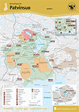
Map: Koli Ruunaa Patvinsuo Petkeljärvi, water resistant outdoor map 1:25 000. Karttakeskus 2020.

Patvinkierto Circle Trail (shortest option 25 km)
When there is no snow on the ground. The trail leads through level, easy to cross terrain. During summer, hikers can take a small ferry across the River Nälmänjoki. No winter maintenance.
Hikers should reserve one to two days to walk this trail.
Hiking Structures
- Camping and campfire sites can be found at Nälmänpuro, near the bird watching tower at Teretinniemi, at Majaniemi on the shore of Lake Koitere and at Lake Pirskanlampi.
- A lean-to shelter with a campfire site can be found near the bird watching tower at Teretinniemi.
- Dry toilets can be found at Lake Lahnalampi and at all camping sites.
- Recycling points can be found at Kurkilahti and at Suomu Nature Information Hut.
- There are swimming spots at Kurkilahti on the shore of Lake Suomunjärvi and at Majaniemi on the shore of Lake Koitere. There is no official swimming spot in the area.
Route Description
The trail is marked with orange-yellow circles.
 Patvinkierto Circle Trail (shortest option 25 km) leads through level, easy to cross terrain in the southern part of the park. Hikers can set off on the shortest option for this trail from Lahnalampi parking area in the western part of the park. The trail is longer (3 to 8 km) if hikers set off from Suomu Nature Information Hut, from Kurkilahti parking area or from Jokivaarankangas parking area. During summer, hikers can take a small ferry across the River Nälmänjoki. The trail leads through the beautiful open mires of Patvinsuo National Park, where spruce and pine mires bring variety to the areas scenery. Hikers can also stop off at the bird watching tower at Teretinniemi from where the view of the mires spreads out.
Limitations and Restrictions
- The trail leading from Lahnalampi parking area to Pirskanlampi camping site leads at points through the Finnish Frontier Guard's restricted military area.
- In winter the trail (Suomu - Nälmänpuro - Surkanpuro - Suomu 10 km) occasionally has a snowmobile track that can be used as a skiing trail.
- The ferry that crosses the River Nälmänjoki near Koitere is not in use from 31.10. to early spring (mid-May).
- Entering restricted areas is forbidden during certain times except on marked trails.
Connected to: Susitaival Trail and Karhunpolku Trail.
- Map: Koli Ruunaa Patvinsuo Petkeljärvi, water resistant outdoor map 1:25 000. Karttakeskus 2020.
- By combining Suomunkierto Circle Trail and Patvinkierto Circle Trail you can pick a route ranging from 40 to 65 km.
Other Trails
The Karelian Circuit has its connecting point in Patvinsuo. The circuit includes Susitaival Trail (ilomantsi.fi, in Finnish) in Ilomantsi (90 km) och Karhunpolku Trail (visitkarelia.fi) in Lieksa (133 km). All these trails start from Suomu Nature Information Hut and head in different directions from there. Susitaival Trail and Karhunpolku Trail are marked with orange-yellow circles. Maps of the Karelian Circuit can be enquired about from Visit Karelia Tourist Services (visitkarelia.fi).
Check for Warnings
 When wildfire warnings (en.ilmatieteenlaitos.fi) are in effect, fire is only allowed at covered campfire sites that have a flue. A fire can be also lit in fireplaces at wilderness and other huts. Always use extreme caution when handling fire. The one who lights a fire is always responsible for its safe use. Please note, that making fire at these campfire sites can be banned locally.


Patvinsuo Brochure