Neitvuori-Luonteri Area Directions and Maps
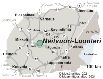
The Neitvuori-Luonteri area is located on the north side of main road 62.

Directions
Neitvuori is 22 km from Anttola parish village and approximately 40 km from Mikkeli. Neitvuori is located on the west shore of Lake Luonteri.
By Car
Neitvuori parking area, Neitvuorentie 660. Road and parking area are maintained during the winter season.
- When arriving from the direction of Mikkeli, drive towards Anttola on the Mikkeli-Puumala road (no. 62), from which there are signs leading to Neitvuori. When arriving from the direction of Juva, drive to Kokkosenlahti, from which there are signs leading to Neitvuori.
By Boat
Boaters can arrive at Lake Luonteri from the direction of Anttola or Puumala.
- The western parts of the area can be reached from Anttola or via the Väätämönsalmi strait.
- The eastern parts of the area can be reached via the Lietvesi bridge.
- Luonteri has several excursion harbours. Consult Special services for boaters for more detailed information.
By Public Transportation
- There is no public transportation to the area. The nearest bus service is to Siikakoski, from which it is 15.5 km to Neitvuori. The bus operates once a day on weekdays between Juva and Siikakoski. There is bus service from Mikkeli to Anttola, which is 22 km from Neitvuori, several times a day on weekdays. Always check the bus timetables (matkahuolto.fi).
Starting Points for Excursions
- It is easy to take a boat or canoe/kayak to the clear waters of Lake Luonteri from Anttola, which is about 10 km away from, for example, the Iso-Kankainen excursion harbour.
- Trail starting points
Maps


- Excursionmap.fi of Metsähallitus
- Head out into lake nature (visitmikkeli.fi)
- National Land Survey of Finland (NLS) map site (maanmittauslaitos.fi)
Other Maps
- Outdoor GT map Southern Finland, 1:250,000. Karttakeskus 2019. Available from Karttakeskus and well-stocked book shops.
- Topographic maps M521, M522 and M523, 1:50,000. Maps are sold by Karttakeskus and the National Land Survey of Finland.
- Hiidenmaan polut, 1: 25,000 (Hiidenkierros Circle Trail approx. 1: 15,000), Hiidenmaan Retket ry 2004. Available from Mikkeli tourism points.
- Veskansa routes - water touring map, 1:80,000, Karttatiimi Oy. You can enquire about and buy maps at, for example, tourism points in Mikkeli, Puumala and Ristiina as well as the Anttola service point.
- Inland water map series: L Lappeenranta - Savonlinna, 1:40,000, Genimap 2012. Maps can be purchased from, for example, Karttakeskus.
- Saimaa chart No 208, 1:50,000. Maps can be purchased from, for example, Karttakeskus and well-stocked bookstores.
- General map 921, Vuoksi watercourse 1:250,000, 2014. Maps can be purchased from, for example, Karttakeskus.
- Waterproof boating map Mikkeli Luonteri Yövesi, 1:50,000, Karttakeskus 2017. Maps can be purchased from Karttakeskus.
- Topographic maps 3142 01, 10 and 11, 3143 03 and 06, 3144 01, 02 and 04, 1:20,000. Maps are sold by Karttakeskus and the National Land Survey of Finland.

