Hiking Trails
 Some of the trails of the Päijänne National Park have been graded according to the Finnish system of classification of outdoor recreation routes. The demand levels of the area's routes can be found on this page in the trail descriptions. The trails of this area are mainly easy or medium demand level.
Starting Points for Trails
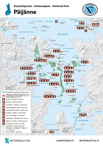
- In Asikkala at Pulkkilanharju Ridge, the parking area by the bridge on Karisalmi Strait
- On the island of Kelvenne in Padasjoki, the excursion harbours in Kirkkosalmi and Likolahti
- You can set off for the Päijätsalo Nature Trail from the vicinity of the parking area located next to the Päijätsalo observation tower. You can also reach Päijätsalo by boat. There is a jetty for small boats next to the Pyydysniemi campfire site. A jetty for larger boats can be found about 100 metres north of the Pyydysniemi campfire site.
Starting Points for Boating Routes
- In the guest harbour in the village of Vääksy in Asikkala
- In Padasjoki Harbour
- In Sysmä Guest Harbour
- Quays in Pyydysniemi in Päijätsalo
Nature Trails
- Pulkkilanharju Nature Trail, approx. 2 km, and connecting loop trail approx. 2,4 km You can walk either the nature trail or the entire marked trail (4,4 km). Pulkkilanharju trail leads through a beautiful ridge and lake scenery. Along the trail you will come across one steeper slope with stairs, and on the wet parts of the trail you will find duckboards. There are some crossroads and forest road crossings along the trail. Major part of the terrain along the trail is fairly easy and the classification of the trail is easy. Look at the map (visitpaijanne.fi, pdf in Finnish).
- Services: There is a kiosk in the parking area during the summer.
- Demand level: Easy trail

Pulkkilanharju Nature Trail Map (excursionmap.fi, opens in a new window)

Other Trails
- Through Kelvenne Island goes a hiking trail, which is marked with blue signs. The trail runs from Kirkkosalmi in the southern end all the way to Likolahti in the northern end, so it is as long as Kelvenne Island, 8 km. The terrain is mostly dry forest which is quite easy to walk. At some places the trail goes up the slopes of the esker. Kelvenne trail is classified as intermediate because of some elevation change and partly rocky trail. Look at the map (visitpaijanne.fi, pdf in Finnish).
- Services: The trail goes past many campfire sites (Kirkkosalmi, Hinttolanhiekka, Nimetön, Koukunlahti, Karhunkämmen, Isohieta, Likolahti).
- Demand level: Medium level trail
Kelvenne Island Hiking Trail Map (excursionmap.fi, opens in a new window)
- Päijätsalo Circle Trail, 4,1 km. Päijätsalo is situated about 7 kilometres west of the parish village of Sysmä. Driving from the parish village, follow the signposts from Suopellontie Road to the parking area located next to the observation tower. The nature trail starts at this point. The nature trail has been marked in the terrain with blue paint signs and the connecting trail with red ones. The trail from the Päijätsalo parking area to Pyydysniemi has been marked with red paint signs on trees. The trail running around the Päijätsalo area: from the parking area, walk for 800 metres along the trail marked with red signs. At the crossroads, continue onto the trail marked with blue signs; this trail runs around the Päijätsalo area and returns to the parking area. At Päijätsalo's highest point, you can climb to the observation tower. Due to the elevation changes in the middle section of the trail and some rocky parts the Päijätsalo trail is classified as intermediate. Look at the map (visitpaijanne.fi, pdf in Finnish).
- Services: There is firewood at the Pyydysniemi campfire site. There is also a dry toilet next to the site. There is no waste management, so you must take away everything that you bring with you. The parking area located next to the Päijätsalo observation tower and the Pyydysniemi jetties.
- Sights: From the observation tower, beautiful views open out onto Tehinselkä, which is Lake Päijänne's largest stretch of open water. The Päijätsalo observation tower was used for flight control tasks during the war (1939 - 1944).
- Demand level: Medium level trail
Päijätsalo Circle Trail Map (excursionmap.fi, opens in a new window)
- Kammiovuori Trail, 3,8 km, is situated in Vintturi, 24 kilometres north of the village of Sysmä. There is a signpost directing to Kammiovuori on road no. 612 to Luhankaa. In the parking area you can find information on the services offered at Kammiovuori. There is also information on the area's natural features along the trail. You can admire the scenery of Lake Päijänne from the top of Kammiovuori Hill. At the top you can also find a map of the islands in Päijänne. A 3,8 km long trail winds down Kammiovuori Hill, marked with white and blue marks. The trail is rocky in places. From Kammiovuori you can hike to Purnuvuori Hill, which is situated in Hartola. However, this part of the trail doesn't have signposts.
- Services: There is a lean-to shelter with a campfire site approximately half way along the trail. There is no firewood, so everyone should bring their own.
- Sights: Kammiovuori Hill is the highest hilltop (221 m) in Eastern Häme. Along the trail, you will also find the Hiskia cave which, according to oral tradition, was home to a hermit living there in the early 20th century. Hikers are free to visit the cave on their own responsibility. At Kammiovuori Hill, you can see the erratic boulders left behind by the Ice Age, the greatest of which is the Sysmän Linta, a boulder nearly seven metres tall.
- Demand level: Medium level trail
Kammiovuori Trail Map (excursionmap.fi, opens in a new window)
- From Padasjoki Harbour begins Päijänne - Ilves connection trail, which goes to Evo Hiking Area and joins up with Ilvesvaellus hiking trail. This trail is marked with painted yellow circles, and it is 12,6 km long. The connection trail ends at Lake Tarusjärvi in Evo, where you can continue on Ilvesvaellus trail in Evo Hiking Area. Both the connection trail and Ilvesvaellus trail are marked in Ilvesvaellus outdoor map. Look at the map (visitpaijanne.fi, pdf in Finnish).
- Services: Nuijamiehenkolo lean-to shelter, Majatalo Onnenmyyrä: accommodation and food
- Sights: Memorial of the Cudgel War (Nuijasota - Peasant Revolt in 1596 - 97), the nature reserve of the municipality of Padasjoki: Lake Frans Joosefin lampi with the surrounding forests
- Demand level: Medium level trail
- The Aurinko-Ilves connecting trail is a 30 km route, which sets off from the southeast corner of Evo Hiking Area and leads to Päijännetalo (asikkala.fi, in Finnish) at Vääksy Channel. The trail travels across changing forest and cultural landscape, which still exhibit signs left behind by the Ice Age. The trail is marked in the terrain with round Aurinko-Ilves symbols. The trail goes through varying landscapes of villages and forests along paved cycling trails, gravel roads, logging roads, fields and forest paths. Trail is classified as intermediate. Look at the map (visitpaijanne.fi, pdf in Finnish).
- Services: Kaupinsaari, Uusimylly, Kuurnamäki and Aurinkovuori lean-to shelters.
- Sights: Lookout points at Korppikallio, Henrikinaho and Syrjänsupat.
- Demand level: Medium level trail


Skiing Trails
- The municipality of Padasjoki maintains a skiing trail on the ice of Lake Päijänne, depending on snow and ice conditions. The trail follows this route:
- Padasjoki Guest Harbour - Vähä-Haukkasalo Island (3 km), Vähä-Haukkasalo Island - the eastern end of Lietsaari Island (3,5km), the eastern end of Lietsaari Island - Isohieta on Kelvenne Island (2,5 km), Isohieta - the campfire site of Hietasaari Island (5 km). The trail is made on the ice depending on the weather. The first section to be made is Padasjoki Guest Harbour - Vähä-Haukkasalo Island.
- Information on the skiing trail from the municipality of Padasjoki (padasjoki.fi).
Boating and Canoeing Routes
- In the water areas around the park, the boat channels are 2,4 metres deep. Southeast of Kelvenne Island there is a section where the channel is only 1,8 deep at some places.
-
The southernmost landing places of Päijänne - Keitele Boating Route are excursion harbours of the National Park. The route goes from South Päijänne all the way to upper Keitele. There are 31 maintained landing places along the route.
-
The waters surrounding the National Park are well suitable for canoeing. There is no marked route on the lake. It is wise to avoid the largest open water areas, because if it is windy, the waves can be high. Visitors should remember to keep long enough distance to the islands where landing is not allowed, so that it is peaceful for the birds to nest.
-
The circular canoeing route of Savonselkä (Kyyvesi - Puula - Päijänne) goes to Kelvenne Island, and from there continues to Suopelto in Sysmä, and then along Tainionvirta River towards Puula. Maps about the route have been published, and they can be occasionally found and bought in the municipalities along the route.

Päijänne Brochure
Check for Warnings
 When wildfire warnings (en.ilmatieteenlaitos.fi) are in effect, fire is only allowed at covered campfire sites that have a flue. A fire can be also lit in fireplaces at wilderness and other huts. Always use extreme caution when handling fire. The one who lights a fire is always responsible for its safe use. Please note, that making fire at these campfire sites can be banned locally.


