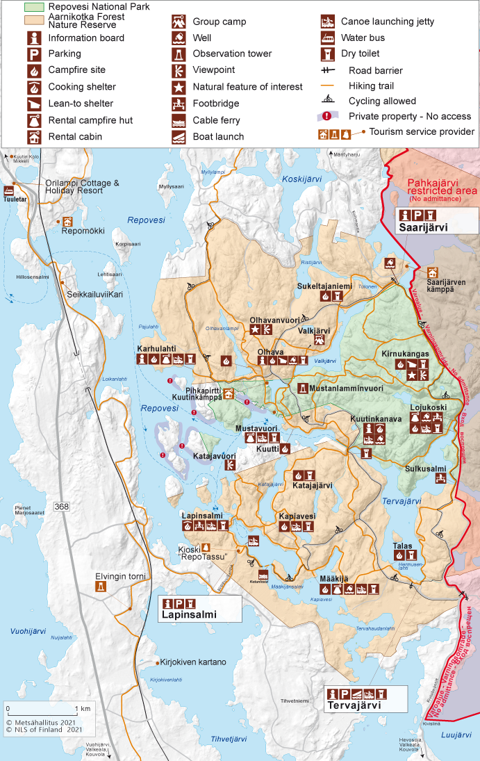
Maps of Repovesi National Park
17.1.2024, updated 31.5.2024
The Lapinsalmi Bridge in Repovesi National Park is temporarily closed. Hikers are requested to arrive at Repovesi National Park through the parking areas of Tervajärvi and Saarijärvi. From Lapinsalmi, you can access the trails using the Ketunlossi ferry and the crossing boat, whose schedules can be found on our website in the 'what's new' page.
Repovesi Brochure
Trail Brochures of Repovesi National Park
- Kaakkurinkierros Trail (pdf, 2 Mb, julkaisut.metsa.fi)
- Ketunlenkki Trail (pdf, 3,6 Mb, julkaisut.metsa.fi)
- Korpinkierros Trail (pdf, 1,9 Mb, julkaisut.metsa.fi)
- Koppelonkierros Trail (pdf, 3,4 Mb, julkaisut.metsa.fi)
- Fell Summits (pdf, 2,6 Mb, julkaisut.metsa.fi)
- Trail Running (pdf, 2,9 Mb, julkaisut.metsa.fi)
- Repovesi for Mountain Bikers (pdf, 2,4 Mb, julkaisut.metsa.fi)
- Snowshoeing in Repovesi (pdf, 1,9 Mb, julkaisut.metsa.fi)
Other Maps


Excursionmap.fi is a free map service provided by Metsähallitus. It can be used to search destinations, choose map layers and print maps.
Printed Maps
- Repovesi Mäntyharju, water resistant outdoor map, 1:15 000 / 1:40 000, Karttakeskus 2021.
- Repovesi Mäntyharju Paistjärvi, waterproof outdoor map, 1:15 000 ja 1:50 000, Calazo Förlag 2020.
- Repovesi hiking guide, Tommi Sirviö & Mikko Lamminpää, Calazo 2020.
- Retkeily GT Etelä-Suomi: GT Outdoor Map Finland South, 1:250 000, Karttakeskus 2019.
- Repovesi Mäntyharju, water resistant map, 1:25 000 and 1:50 000, Calazo Förlag 2016.
- Terrain map M433, 1:50 000, National Land Survey of Finland 2014.
- Repoveden kansallispuiston palvelukartta (The service map of Repovesi National Park), A3, Metsähallitus 2017. The map is available at the VisitKouvola office.
- Repovesi pieni retkiopas, 1:15 000, Karttakeskus 2013.
- Maastokartat: Terrain maps nos 3114 08, 11 and 12, 1:20 000, National Land Survey of Finland 1998.


