Directions to Rokua National Park

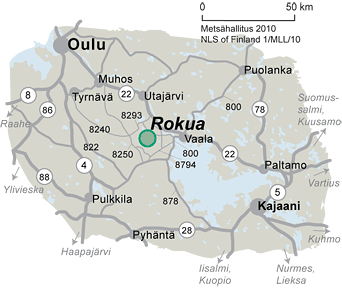
Rokua National Park is located in Northern Ostrobothnia, just south of Highway 22. From Utajärvi, the distance to the park is about 25 km to the south; from Vaala, about 20 km to the west. The nearest airport and railway station are located in Oulu in 83 km.
To the Hiking Trails
The hiking trails can be accessed from the lake Pitkäjärvi, Pooki or Rokua Outdoors (former Suppa Information Centre) parking areas, or from the Rokua Health & Spa, Hotel Rokuanhovi, and the Rokua Camp Centre.
Starting points for summer trails and starting points for winter trails.
To Rokua by bus
Oulu-Utajärvi-Rokua-Vaala bus is running on every day 5.6.-6.8.2023 and on weekends 7.8.-1.10.2023. Buy tickets and check the timetables (matkahuolto.fi).
To Rokua by train
The distance from Vaala railway station to Rokua National Park is around 18 kilometres. There is a bus connection from Vaala to Rokua.
To Car by Rokua
Pitkäjärvi parking area at the southern edge of the park. WGS84 coordinates: N 64.54879 E 26.49744
Pookivaara parking area. WGS84 coordinates: N 64.57084 E 26.48992
Rokua Health & Spa. Kuntoraitti 2, Rokua.
Hotel Rokuanhovi / Rokua Ski Stadium. Jaakonjärventie 43, Rokua.
Rokua Camp Centre. Salmisentie 300, Rokua.
Rokua Outdoors. Rokuanhovintie 2.
Please note that the national park’s parking areas are not open in winter. The northern parts of Rokuanvaara can be accessed by turning from Highway 22 (Oulu-Kajaani) onto road 8293 that goes via Ahmas village and has signposts to the area. The national park’s southern border can be reached by taking road 8794 until Neittävä and following the signposts to the park.


