


Pitkäjärvi's demanding accessible trail 0.8 km / one-way
Available when the ground is unfrozen. No winter maintenance.
Travel time 1 hour
Category:  demanding accessible trail
From the Pitkäjärvi parking area, follow the 0.8 km long rock dust trail that is suitable for wheelchair users. The trail is a demanding accessible trail due to a couple of steeper hills and other challenges. There is also lateral gradient over a few metres.
Starting Point
Pitkäjärvi parking area, Keisarintie 1720, 92810 Vaala
Hiking Structures
Pitkäjärvi campfire hut and outdoor toilet are accessible but the firewood shelter is not.
Trail Description
From the Pitkäjärvi parking area, there is a 0.8 km rock dust trail to the Pitkäjärvi hut which is suitable for wheelchair users. The trail is a demanding accessible trail due to a couple of steeper hills (up to 24% longitudinal gradient). There is also lateral gradient over a few metres (approximately 6%). The trail is mostly in good condition and flat, but in rainy weather, the trail is soft in places and there are roots and ruts left by service vehicles at a few places on the trail.
There is a road block at the end of Pitkäjärvi parking area at the beginning of the trail but it is possible to go around it. The free width around the road block is 1.1 metres on both sides.
Trail markings
Yellow and blue paint marks.
Please Note
Firewood shelter and path to Pitkäjärvi shore are not accessible. If you are driving, it is a good idea to arrive to the starting point from the south via Neittävä, as the Keisarintie road is often in poor condition.


Harjunpolku 2.5 km, Circle Trail
Available when the ground is unfrozen. No winter maintenance.
Travel time 1 hour
Category:  Easy
Easy  Intermediate (slight altitude differences)
Harjunpolku is a short and easy trail that is also suitable for children. It runs along an esker terrain between Rokua Health & Spa and Lake Lianjärvi.
Starting Point
Rokua Health & Spa, Kuntoraitti 2, Rokua
Hiking Structures
Lianjärvi day-use hut and dry toilet.
Trail Description
The Harjunpolku Trail is an easy circle trail that runs along an esker terrain in the surroundings of Rokua Health & Spa and the lakeside scenery of Lianjärvi. The trail is also suitable for children. You can take a break at a day-use hut on the shore of Lake Lianjärvi. There used to be a dance stage at the site of the hut. You will find the starting point of Harjunpolku Trail behind Rokua Health & Spa, close to the shore of Ahveroinen Pond. The trail can be travelled both anticlockwise and clockwise.
The northern section of the trail runs along the crest of a low esker, amid a pine forest and lichen heaths. The western section of the trail passes along a narrow natural path, close to the shore of Lake Lianjärvi, where you will see old pines and lusher trees. The southern and southeastern sections of the trail between the Lianjärvi day-use hut and Rokua Health & Spa consist of a wide stone dust path through a hilly terrain, amid a light-filled pine forest.
Trail markings
The trail has been marked on trees with blue paint signs. There are brown signposts at the intersections.
Top 3
- Landforms shaped by the Ice Age
- Lichen heaths
- A break at the Lianjärvi day-use hut
Please Note
- The eastern section of the trail crosses a road at two points, and there may also be mountain bikers in the southeastern and southern sections of the trail.
- The terrain is sensitive to erosion, so please keep to the marked trails and only camp at the marked rest spots.
- Only light an open campfire at marked rest spots, using the firewood reserved for the purpose. During the periods of wildfire warnings, lighting a fire is prohibited in the entire national park (including inside the campfire huts and day-use huts).
- There are no waste bins along the trail and at the rest spot. Take your rubbish with you from the terrain.
- There is no toilet paper at the dry toilet.
Harjunpolku detailed trail description (pdf 0.7, julkaisut.metsa.fi).


Pookinpolku 4,9 km, Circle Trail
Available when the ground is unfrozen. No winter maintenance.
Travel time 2 hours.
Category: Intermediate (some altitude differences and narrow paths with roots).
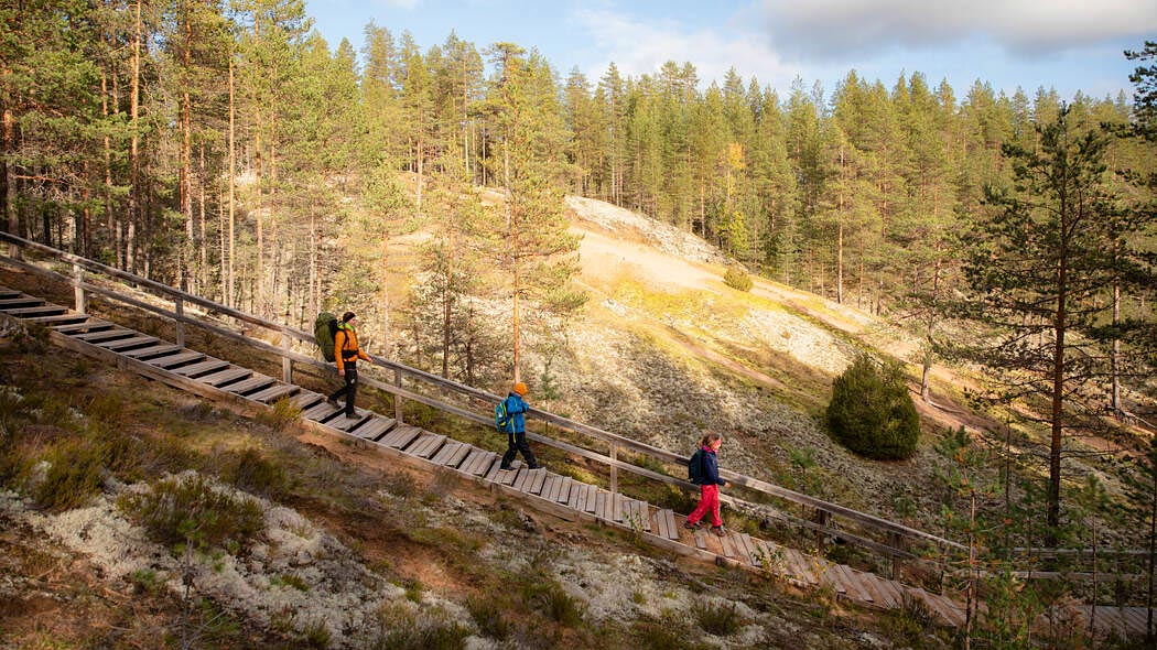
The Pookinpolku Trail takes you, via Pitkäjärvi, to the scenery of Pookivaara Hill, the heart of Rokua National Park, where the fireguards used to work in the past. Here you can see rolling heaths and silvery beds of lichen, in a postglacial landscape formed by dunes, kettle holes and esker slopes.
Starting Point
The Pitkäjärvi parking area (Keisarintie 1720, 92810 Vaala). It is worthwhile driving onto Keisarintie Road from the southern side of Rokua National Park, via Nuojuankoskentie Road.
The Pooki parking area has no official address. The parking area is located along a forest road (the so-called Halkivaarantie Road), which branches off to the left from Salmisentie Road, Utajärvi, after the Rokua Camp Centre. There is a one-kilometre connecting trail from the Pooki parking area to Pookinpolku Trail.
Hiking Structures
The Pitkäjärvi rest stop, with an accessible campfire shelter and an accessible dry toilet.
The Pookivaara rest stop, with the Pookin paussi day-use hut, the Palovartija wilderness hut, an observation tower and a dry toilet.
Trail Description
The Pookinpolku Trail passes around the gorgeous Lake Pitkäjärvi and continues through a handsome pine forest, all the way to the top of Pookivaara Hill. Pookivaara is the Rokua National Park’s highest point, where the fireguards used to watch over Rokuanvaara, which is very vulnerable to fires.
You can set off for Pookinpolku Trail from the Pitkäjärvi parking area, by Keisarintie Road. The initial section of the trail is wide and has a stone dust surface (0.8 km). This section also functions as an accessible trail. From Pitkäjärvi onwards, the trail can be travelled both anticlockwise and clockwise. Here, the trail becomes narrower, following the shores of Lake Pitkäjärvi through an old pine forest. Alternatively, you can set off for the trail from the Pookivaara parking area, from which there is a one-kilometre connecting trail to the Pookinpolku Trail.
The eastern section of the trail between Pitkäjärvi and Pookivaara runs along an open, gently rolling pine heath, amid beds of lichen. Along this section, there are long stairs that ascend to the north. The western section of the trail runs via the shores of the idyllic Lake Hätäjärvi through a varied pine forest. Here, the terrain is also undulating.
You can take a break either on the top of Pookivaara Hill or at a rest spot on the lakeside of Pitkäjärvi. There are also other rest spots located along the trail.
Trail markings
The trail has been marked on trees with blue paint signs. There are brown signposts at the intersections.
Sights
- Pookivaara Hill
- Lake Pitkäjärvi
- Lichen heaths
Please Note
- There may also be mountain bikers in the southern and western sections of the trail (between the Pitkäjärvi parking area and the Pookivaara rest spot).
- The terrain is sensitive to erosion, so please keep to the marked trails and only camp at the marked rest spots.
- Only light an open campfire at marked rest spots, using the firewood reserved for the purpose. During the periods of wildfire warnings, lighting a fire is prohibited in the entire national park (including inside the campfire huts and day-use huts).
- There are no waste bins along the trail and at the rest spot. Take your rubbish with you from the terrain.
- There are stairs along the trail.
- There is no toilet paper at the dry toilets.
Pookinpolku (Pooki trail) detailed trail description (pdf 0.7 MB, julkaisut.metsa.fi).


Syvyydenkierros 6,2 km, Circle Trail
Available when the ground is unfrozen. No winter maintenance.
Travel time 2-3 hours.
Category: Intermediate (There are many ascents, descents and stairs in places. Some sections of the trail are narrow and root-filled, and there may be fallen trees on the ground.)
The Syvyydenkierros Trail runs along the undulating eskers of Rokuanvaara, amid the silvery beds of lichen. Along the trail, you will see a landscape shaped by the Ice Age and Syvyydenkaivo (the ‘Well of the Depths’), which is Finland’s deepest kettle hole in its natural state.
Starting Point
Rokuanhovi (Jaakonjärventie 43, 91670 Rokua) or the Pooki parking area. The Pooki parking area has no official address. It is located along a forest road (the so-called Halkivaarantie) that branches off to the left from Salmisentie Road, Utajärvi, after the Rokua Camp Centre.
Hiking Structures
There are no rest spots along the trail, but there is a connecting trail (0.4 km) from the southern section of the trail to the Pookivaara rest spot. Services provided by Hotel Rokuanhovi.
Trail Description
The Syvyydenkierros Trail is a varied circle trail that runs along an esker terrain, amid pine forests. Along the trail, you will find light-coloured beds of lichen, sand dunes covered with plants and the Syvyydenkaivo kettle hole, which is one of the most famous natural features of interest in Rokua. You can set off for the trail either from Hotel Rokuanhovi or the Pooki parking area. The trail can be travelled both anticlockwise and clockwise.
The northern section of Syvyydenkierros Trail runs along a gently rolling, light-filled pine heath, amid beds of lichen. This section of the trail has two sets of steps. They ascend towards the west, on the eastern slope of Vauluvaara Hill.
The western section of Syvyydenkierros Trail passes along the slope of a scenic esker. Halfway through this section, you will see Syvyydenkaivo, which is Finland’s deepest kettle hole in its natural state. There is a steep and sunny southern slope between the bottom of the kettle hole and the ridge of a dune. Difference between kettle's dry upper parts and the its wet bottom is visible. On the edge of the slope, there are stairs that ascend towards the north.
The southern section of the trail runs along a wide track amid pine forests. This section has some fairly steep ascents and descents, and the trail runs between two kettle holes, which are called Pookinkuppi and Kakkoskuppi.
Close to the Pooki parking area, the trail runs, for a short time, along a forest road. The eastern section of the trail between the Pooki parking area and Hotel Rokuanhovi takes you across spacious beds of lichen and a clearing that is becoming overgrown. On the southern side of Hotel Rokuanhovi, the trail passes by Rokua Ski Stadium.
Trail markings
The trail has been marked on trees with blue paint signs. There are brown signposts at the intersections.
Top 3
- Lichen heaths
- Landscape shaped by the Ice Age
- The Syvyydenkaivo kettle hole
Please Note
- The trail runs across a forest road in places, and there may also be mountain bikers in the eastern section of the trail (between Hotel Rokuanhovi and the Pooki parking area).
- The terrain is sensitive to erosion, so please keep to the marked trails and only camp at the marked rest spots.
- Only light an open campfire at marked rest spots, using the firewood reserved for the purpose. During the periods of wildfire warnings, lighting a fire is prohibited in the entire national park (including inside the campfire huts and day-use huts).
- There are no waste bins along the trail and at the rest spot. Take your rubbish with you from the terrain.
- There are stairs along the trail.
Syvyydenkierros detailed trail description (pdf 0.7 MB, julkaisut.metsa.fi).


Keisarinkierros 20 km, Circle Trail
Available when the ground is unfrozen. No winter maintenance.
Travel time 1-2 Days.
Category: Intermediate. (There are many ascents, descents and stairs in places. Some sections of the trail are narrow and root-filled, and there may be fallen trees on the ground.)
The Keisarinkierros Trail (‘Emperor’s Trail’) takes you to the most popular natural features of interest and nature destinations in Rokuanvaara. Along the trail, you will see Syvyydenkaivo (the ‘Well of the Depths’), which is Finland’s deepest kettle hole in its natural state, and Pookivaara Hill, which is the highest point in Rokua, as well as the enchanting lakes.
Starting Points
Rokua Health & Spa (Kuntoraitti 2, 91670 Rokua)
Rokuanhovi (Jaakonjärventie 43, 91670 Rokua)
Rokua Outdoors (Rokuanhovintie 2, 91670 Rokua)
Hiking Structures
- The Lianjärvi day-use hut and dry toilet
- The Kirvesjärvi campfire hut and dry toilet
- The Saarinen campfire hut and dry toilet
- The Pookivaara rest spot (a day-use hut, wilderness hut, dry toilet, observation tower)
- The Pitkäjärvi accessible campfire hut and accessible dry toilet
- The Rokuanjärvi campfire hut and dry toilet
- The services provided by Hotel Rokuanhovi, Rokua Outdoors and Rokua Health & Spa.
Trail Description
The Keisarinkierros Trail takes you to the most popular natural features of interest and nature destinations in Rokua National Park. The trail has received its name after the historical Keisarintie (‘Emperor’s Road'), which runs through Rokua.
Along the trail, you will find crystal-clear lakes, as well as campfire huts and two day-use huts, at which you can take a break and enjoy the peace and quiet of Rokua. You can set off for Keisarinkierros Trail by Rokua Health & Spa, Hotel Rokuanhovi or Rokua Outdoors. The trail can be travelled both clockwise and anticlockwise. It is very suitable for overnight stays.
The Keisarinkierros Trail chiefly runs along rolling heaths, amid beds of lichen and pine forests. There are easy stone dust paths and a dirt road along the northern section of the trail. In the western section of the trail, you will see the crystal-clear Lake Saarinen, Syyvydenkaivo, which is Finland’s deepest kettle hole in its natural state, Pookivaara Hill, which is the highest point in Rokua, and the gorgeous Lake Pitkäjärvi. You will find the oldest and most natural-state parts of Rokua National Park in the southern part of Keisarinkierros Trail. In the northeast, between Rokua Health & Spa and Hotel Rokuanhovi, the trail runs along a pavement.
Trail marking
The trail has been marked on trees with white, round paint signs. There are brown signposts at the intersections.
Please note that the white, transverse paint signs on trees are border signs of Rokua National Park. Be careful not to confuse them with the white, round paint signs for Keisarinkierros Trail!
Top 3
- Pookivaara Hill
- The Syvyydenkaivo kettle hole
- Crystal-clear lakes
Please Note
- The trail crosses a road in places, and there may also be mountain bikers in some sections of the trail.
- The terrain is sensitive to erosion, so please keep to the marked trails and only camp at the marked rest spots.
- Only light an open campfire at marked rest spots, using the firewood reserved for the purpose. During the periods of wildfire warning, lighting a fire is prohibited in the entire national park (including inside the campfire huts and day-use huts).
- There are no waste bins along the trail and at the rest spot. Take your rubbish with you from the terrain.
- There are stairs along the trail.
Keisarinkierros detailed trail description (pdf 1.3 MB, julkaisut.metsa.fi).
Rokua Brochure

Rokua Summer Trails

 Check for Warnings

When there is a wildfire warning in force, making fires in prohibited throughout Rokua National Park, including in fireplaces with air chimneys. The area’s dry lichen heaths can very easily catch fire. The person starting the fire is always responsible for its safety. Please note that making fires may also be prohibited for specific locations.