

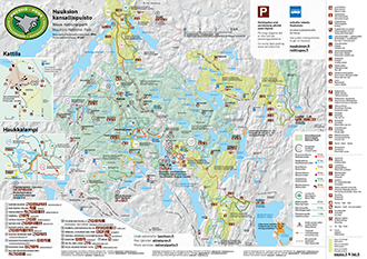
Recommended at Nuuksio
Punarinnankierros Trail, 2 km Circle Trail
Estimated time 1 h, no winter maintenance.
An easy trail.
As the easiest circle trail in Nuuksio, Punarinnankierros is ideal for beginners. The sights along the trail include the beautiful dry heath forests of Nuuksio and small lakes, the most spectacular one of which is Mustalampi with its floating mats of peat moss.

Starting Point
Address: Haukkalampi, Haukkalammentie 32, 02820 Espoo (pdf 6,2 MB, julkaisut.metsa.fi).
Coordinates for Haukkalampi: Euref-Fin (~ WGS84) lat: 60° 18.8649' lon: 24° 31.2936' ETRS-TM35FIN N: 6689001 E: 363094
Services and hiking structures
Haukkalampi Nature Information Hut at starting and ending points, water available at the Guide Hut, camping site, campfire site and cooking shelter at Lake Mustalampi.


Sights
The turf floats of Lake Mustalampi.
Route Description
Route markings: red.


Haukankierros Trail, 3.7 km Circle Trail
Estimated time 2 h, no winter maintenance.
Challenging due to height differences.
Haukankierros treats visitors to spectacular landscapes created by the Ice Age: valleys and ravines as well as old-growth forests. You can admire the beautiful landscapes of Myllypuro valley from a height and enjoy the excellent services for hikers along the trail, including the cooking shelter beside Mustalampi Lake.

Starting Point
Address: Haukkalampi, Haukkalammentie 32, 02820 Espoo (pdf 6,2 MB, julkaisut.metsa.fi).
Coordinates for Haukkalampi: Euref-Fin (~ WGS84) lat: 60° 18.8649' lon: 24° 31.2936' ETRS-TM35FIN N: 6689001 E: 363094
Services and hiking structures
Haukkalampi Nature Information Hut at starting and ending points, water available at the Guide Hut, camping site, campfire site and cooking shelter at Lake Mustalampi.
Sights
The scenery to Brook Myllypuro valley, and the turf floats of Lake Mustalampi.

Route Description
Route markings: blue.
Please note
At the halfway of the trail, west side of Haukkalampi lake there are about 30 meters long steel stairs. It is possible for a dog to walk beside the stairs.

Korpinkierros Trail, 6-7.2 km Circle Trail
Estimated time 4 h, no winter maintenance.
A challenging trail.
Korpinkierros impresses even the experienced hiker with its cliffs and diverse natural environment. Explore the herb-rich forests and be enchanted by the ponds.

Starting points
Coordinates for Haukkalampi: Euref-Fin (~ WGS84) lat: 60° 18.8649' lon: 24° 31.2936' ETRS-TM35FIN N: 6689001 E: 363094
Coordinates for Siikaniemi: Euref-Fin (~ WGS84) lat: 60° 17.3591' lon: 24° 30.8904' ETRS-TM35FIN N: 6686221 E: 362617
Services and hiking structures
Haukkalampi Nature Information Hut at starting and ending points, water available at the Guide Hut, camping site, campfire site and cooking shelter at Lake Mustalampi, reservable camping site at Lake Kolmoislampi, two campfire sites/ camping sites and a lean-to shelter at Lake Holma-Saarijärvi.

Sights
The turf floats of Lake Mustalampi.
Route Description
Route markings: yellow.
Korpinkierros Trail (7 km) will lead you through the nature filled with ponds.


Easy Trails
Takala Trail, 1.5 km/one way
Estimated time 25 min/one way, no winter maintenance.
An easy trail.
Takala trail, which leads visitors through forested areas, is an easy walking path. The campfire site at the mid-point of the trail is ideal for taking a break, warming up and having your picnic.

Starting point
Beside Kattila main building. (pdf 6,2 MB, julkaisut.metsa.fi).
Coordinates for Kattila: Euref-Fin (~ WGS84) lat: 60° 19.6976' lon: 24° 29.6322' ETRS-TM35FIN N: 6690603 E: 361623
Hiking structures
Lean-to shelter and campfire site in Takala, campfire site in Kattila. Closest water point is located at Kattila.

Route Description
Route markings: orange signs with black stripes.
Following the Takala Trail (1.5 km) you will get from Kattila to the Takala Lean-to-shelter.
Soidinkierros Trail, 4 km Circle Trail
Estimated time 2 h, no winter maintenance.
An easy trail that mostly meanders along diverse forests.
Get revitalised by the old-growth forest dotted with rocky outcrops!

Starting point
Address: Siikaranta, Hotel Nuuksio, Naruportintie 68, 02860 Kirkkonummi (pdf 6,2 MB, julkaisut.metsa.fi).
Coordinates for Siikaranta: Euref-Fin (~ WGS84) lat: 60° 16.7702' lon: 24° 30.0815' ETRS-TM35FIN N: 6685156 E: 361831
Services and hiking structures
For hikers who like their creature comforts, the hotel services at the start point offer cosy accommodation and delicacies from the restaurant.
Route description
Trail markings: green.
This flat trail takes in views across Soidinsuo, the greatest marshland in Nuuksio.


Kaarniaispolku Nature Trail, 2.7 km circle trail
Estimated time 1 h, no winter maintenance.
Specially designed for schoolchildren, Kaarinaispolku is also suitable for other hikers.
Go hiking and learn about nature while enjoying the forests, marshlands and bare rocky areas! This varied trail even goes past an old landfill.

Starting Point
Address: Kaarniaispolku parking area at the end of Soidentaantie road in Veikkola industrial estate (pdf 6,2 MB, julkaisut.metsa.fi).
Coordinates for starting point: Euref-Fin (~ WGS84) lat: 60° 16.2592' lon: 24° 27.6114' ETRS-TM35FIN N: 6684295 E: 359518
Route description
Trail markings: brown and white pine cone symbols.

The Nature Trail is located at the South-West corner of Nuuksio National Park.
Other Hiking Trails, 0-10 km
Nahkiaispolku Nature Trail, 2 km circle trail
Rather challenging due to the difficult terrain.

Starting Point
Adress: Haukkalampi, Haukkalammentie 32, 02820 Espoo (pdf 6,2 MB, julkaisut.metsa.fi).
Coordinates for Haukkalampi: Euref-Fin (~ WGS84) lat: 60° 18.8649' lon: 24° 31.2936' ETRS-TM35FIN N: 6689001 E: 363094
Route description
Trail markings: brown and white pine cone symbols.

Klassarinkierros Trail, 3.9 km Circle Trail
Estimated time 2 h, no winter maintenance.
Rather challenging due to height differences.
In the more quiet western part of the park, you will be soothed in the embrace of the forest and lakes, breathing in the fresh air of the national park. Enjoy the striking landscapes of Klassarinkallio rock and linger beside Saarilampi Lake, listening to the murmur in the spruce trees.

Starting point
Address: Valklampi parking area, Valklammentie 1, Vihti (pdf 6,2 MB, julkaisut.metsa.fi).
Coordinates: Euref-Fin (~ WGS84) lat: 60° 18.7173' lon: 24° 26.7633' ETRS-TM35FIN N: 6688886 E: 358913
Hiking structures
Saarilampi camping area, campfire site and dry toilet, Tikankolo rental hut (naturaviva.fi) and Polku Hotel (polkuhotel.com)
Sights
Saarilampi and the view from Klassarinkallio to the west.
Route description
Trail markings: purple.


Haukkalampi-Haltia Connecting Trail, 4.6 km
Estimated time 2 h in each direction, no winter maintenance.
Extremely challenging.
The trail connecting Haukkalampi and Haltia with its major height differences is a treat for the hiker in search of challenges. Lunch and café services are available in Haltia, so there is no need to carry your own sandwiches. While having your break, you can relax and enjoy Haltia's interesting exhibitions that change periodically.
Starting Points
Coordinates for Haltia: Euref-Fin (~ WGS84) lat: 60° 17.6269' lon: 24° 33.4218' ETRS-TM35FIN N: 6686630 E: 364967
Coordinates for Haukkalampi: Euref-Fin (~ WGS84) lat: 60° 18.8649' lon: 24° 31.2936' ETRS-TM35FIN N: 6689001 E: 363094
Route Description
Route markings: orange signs with black stripes.
The connecting trail between Haukkalampi and Haltia (4.6 km) starts from the main entrance to Haukkalampi. It contains challenging ascents and descents, with steps in the steepest places. Between Nuuksiontie road and Nuuksionpää road there are about 30 meters long steel stairs in the trail. It is possible for a dog to walk beside the stairs.
Connection
This trailconnects with Päivättärenpolku nature trail in Haltia (1.4 km). The Secret of the Red Feather nature trail (0.2 km) is intended for children. Another circle trail starting around the corner from the centre is Maahisenkierros (2 km). Maahisenkierros trail is accessible for prams, pushchairs and wheelchairs (when assisted). Haltia's nearby nature trails (haltia.com) are located on lands owned by the City of Helsinki and the Solvalla sports institute.

Other Hiking Trails, over 10 km
Trail through Nuuksio National Park, approx. 14 km
No winter maintenance.
The route stretches throughout the entire National Park starting from Siikaniemi, going through Haukkalampi and Kattila or Högbacka all the way to Salmi hiking area.
Starting Points
Siikaniemi, Kolmoislammenranta, 02860 Espoo and Salmi hiking area information point, Salmentie 75, 03300 Otalampi (pdf 6,2 MB, julkaisut.metsa.fi).
Coordinates for Siikaniemi: Euref-Fin (~ WGS84) lat: 60° 17.3591' lon: 24° 30.8904' ETRS-TM35FIN N: 6686221 E: 362617
Coordinates for information point in Salmi hiking area: Euref-Fin (~ WGS84) lat: 60° 22.5374' lon: 24° 30.3336' ETRS-TM35FIN N: 6695847 E: 362468
Route description
Trail markings: Orange markings of Haukankierros connecting trail.
Veikkola-Salmi Connecting Trail, 20 km/one way
No winter maintenance.
Challenging.
Veikkola-Salmi connecting Trail (20 km) will lead you from Veikkola via Siikajärvi and Haukkalampi all the way to Salmi hiking area. You can choose the details of the trail yourself.
Starting Points
Salmi hiking area and Veikkola, Kaarniaispolku Nature Trail parking area (pdf 6,2 MB, julkaisut.metsa.fi).
Coordinates for information point in Salmi hiking area: Euref-Fin (~ WGS84) lat: 60° 22.5374' lon: 24° 30.3336' ETRS-TM35FIN N: 6695847 E: 362468
Coordinates for Kaarniaispolku Nature Trail parking area: Euref-Fin (~ WGS84) lat: 60° 16.2592' lon: 24° 27.6114' ETRS-TM35FIN N: 6684295 E: 359518
Services and hiking structures
Camping sites and other services depend on your choice of the route.
Route description
Trail markings: orange signs with black stripes.
Trail 2000, 110 km
No winter maintenance.
Suitable for biking.
Trail 2000 is a 110-km-long hiking trail, which begins in Laakso in Helsinki, and goes through the National Park. The trail is marked with blue band on the trees.
Starting Point
Address: Lääkärinkatu 8, 00250 Helsinki.
Route description
Trail markings: blue-white ribbons on trees.
Biking Trails, approx. 30 km
The trails consist of roads accessible by car, small cart roads, and short footpath sections. The trails are not as good as urban cycle tracks, but they are driveable by an ordinary bike, walking the footpath sections and hills, if necessary. No winter maintenance.
Nuuksio National Park is accessible by bike. For cyclists there are circular and through trails in the National Park, and they continue onto the surrounding recreational forests. Please note that cycling is only allowed on the trails designated for this purpose (PDF file, 0.1 Mb, julkaisut.metsa.fi. in Finnish).

Starting points
Coordinates for Kattila: Euref-Fin (~ WGS84) lat: 60° 19.6976' lon: 24° 29.6322' ETRS-TM35FIN N: 6690603 E: 361623
Coordinates for Haltia: Euref-Fin (~ WGS84) lat: 60° 17.6269' lon: 24° 33.4218' ETRS-TM35FIN N: 6686630 E: 364967
Coordinates for Haukkalampi: Euref-Fin (~ WGS84) lat: 60° 18.8649' lon: 24° 31.2936' ETRS-TM35FIN N: 6689001 E: 363094
Coordinates for Valklampi: Euref-Fin (~ WGS84) lat: 60° 18.7173' lon: 24° 26.7633' ETRS-TM35FIN N: 6688886 E: 358913
Coordinates for Siikaranta: Euref-Fin (~ WGS84) lat: 60° 16.7702' lon: 24° 30.0815' ETRS-TM35FIN N: 6685156 E: 361831
Also the National Bike Trail Network's route number 2 goes through the National Park from Siikajärvi via Haukkalampi to Salmi.
Services and hiking structures
Oravankolo (naturaviva.fi) and Tikankolo (naturaviva.fi) Rental Huts, the reservable camping site at Lake Kolmoislampi, camping site at Lake Saarilampi and camping site/cooking shelter at Lake Mustalampi.
Sights
The turf floats of Lake Mustalampi.
Riding Trails, approx. 22 km
No winter maintenance.
Did you know that it is possible to ride a horse in Nuuksio National Park? Most of them are former cart tracks, which are used by for example hikers too. Please note that horse riding is only allowed on the trails designated for this purpose (pdf 0.3 Mb, julkaisut.metsa.fi).

Starting points
Kattila and Parking area of Valklampi.(pdf 6,2 MB, julkaisut.metsa.fi, in Finnish).
Coordinates for Kattila: Euref-Fin (~ WGS84) lat: 60° 19.6976' lon: 24° 29.6322' ETRS-TM35FIN N: 6690603 E: 361623
Coordinates for Valklampi: Euref-Fin (~ WGS84) lat: 60° 18.7173' lon: 24° 26.7633' ETRS-TM35FIN N: 6688886 E: 358913
Nuuksio Brochure
Pdf 1.6 Mb (julkaisut.metsa.fi)
Map and services in the vicinity of the Finnish Nature Center Haltia


