Summer Hiking Trails in Syöte
Starting Points and Parking Areas for Summer Trails
- Syöte Visitor Centre, Erätie 1, 93280 Syöte
- Rytinkisalmentie 1834, Pudasjärvi
- Hotel Iso-Syöte, Isosyötteentie 246, 93280 Syöte
- Hotel Pikku-Syöte, Syötekeskuksentie 126, 93280 Syöte
- Ahmaselkosentie 212, Taivalkoski
- Vattukuru parking area, Syötekyläntie 1638, Pudasjärvi
- Soiperoisentie 57-59, Taivalkoski
- Ukonvaara parking area, Karsikkoperäntie 1591
- Ruuhensuontie 1201, 93250 Pudasjärvi
- Kaunislampi trail, 6 km
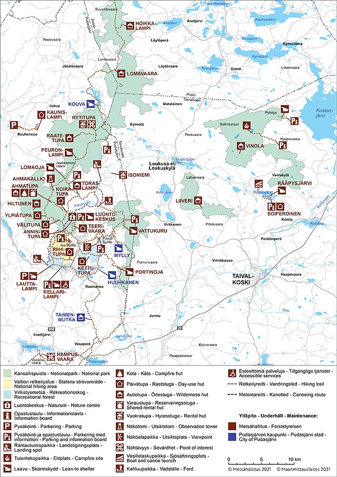
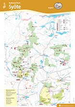
Other Maps


The national park's most extensive network of summer trails zigzags in the Syöte area. The trails have been marked with yellow paint signs on trees.
Korpikolvan polku, 500 m, Circle Trail
Available all year round. No winter maintenance.
Travel time 30 min.
Category:  Easy
Easy  Accessible nature trail
The Korpikolvan polku Nature Trail provides you with an insight into the life of non-migrant birds and their relation to the surrounding area.

Starting point
Syöte Visitor Centre, Erätie 1, 93280 Syöte, Pudasjärvi (google.fi).
Trail Description
The trail starts and ends by Syöte Visitor Centre and runs through an old-growth forest in the surrounding area. The nature trail is available all year round, and in the summer it is accessible by pram or by wheelchair with an assistant.
Hiking Structures
Lean-to shelter.

Pikku-Syöte Nature Trail, 1,8 km, Circle Trail
Available all year round. In summer as a hiking trail and in winter as snow shoe trail. No winter maintenance.
Travel time 1 h.
Category:  Intermediate
Pikku-Syöte nature trail weaves around the top of Pikku-Syöte fell. The viewpoints at the trail offer you spectacular views of the Syöte region. In wintertime you can see beautiful crown snow-loaded trees. The trail can be easily accessed by car.

Starting point
Ski resort Pikku-Syöte, Syötekeskuksentie 126, 93280 Syöte (google.fi)

Vattukuru Nature Trail, 2,1 km, Circle Trail
Available all year round. In summer as a hiking trail and in winter as snow shoe trail. No winter maintenance.
Travel time 2 - 3 h.
Category:  Intermediate
Vattukuru Nature Trail presents you the life, plants and animals in an old-growth forest. Along the fairly short nature trail, you will see a large variety of natural elements, such as a slope bog, lush stream banks and spruce forests. Tips for hikers: there are Siberian flying squirrels in Vattukuru Ravine.

Starting point
Vattukuru parking area, Syötekyläntie 1638, Pudasjärvi (google.fi).
Open Vattukuru Nature Trail brochure (pdf 0.7 MB, julkaisut.metsa.fi).

Naavaparta Trail, 3 km, Circle Trail
Available all year round. No winter maintenance.
Travel time 1 - 2 h.
Category:  Easy
Easy
What is a Pytho kolwensis? How far can a Siberian flying squirrel glide? And what are beard lichen and Alectoria? You will find answers to these questions by hiking along the Naavaparran polku Trail. The gravel trail will introduce trekkers of all ages to the secrets of Syöte.

Starting point
Syöte Visitor Centre, Erätie 1, 93280 Syöte, Pudasjärvi (google.fi).
Open Naavaparta Trail brochure (pdf 1.5 MB, julkaisut.metsa.fi).

Teerivaaran kierros, 4,5 km, Circle Trail
Available all year round. No winter maintenance.
Travel time 3 - 4 h.
Category:  Demanding
The challenging climb to the top of Teerivaara Hill is well worth it, as you'll be treated with magnificent views! Teerivaaran kierros is a perfect destionation for a daytrip with a rest stop at the southern hilltop and peaceful wilderness just a few kilometres from the tourism centre.

Starting point
Syöte Visitor Centre, Erätie 1, 93280 Syöte, Pudasjärvi (google.fi).
Open Teerivaara trail brochure (pdf 1.2 MB, julkaisut.metsa.fi).

Huippupolku, 1 km, Circle Trail
Available when the ground is unfrozen. No winter maintenance.
Travel time 30 min.
Category:  Intermediate
Explore the natural world of Finland's southernmost fell along a guided nature trail on the summit of Iso-Syöte Fell. The summit offers splendid views to Syöte National Park.

Starting point
Iso-Syöte Hotel's parking area, Isosyötteentie 246, 93280 Syöte (google.fi).
Open Huippupolku trail brochure (pdf 1 MB, julkaisut.metsa.fi).

Kellarilampi Nature Trail, 500m each way
Available when the ground is unfrozen. No winter maintenance.
Travel time 30 min.
Category:  Easy
Easy  Accessible nature trail
A lean-to shelter by Kellarilampi pond is an easily accessible destination. Take fishing gear with you as Kellarilampi is famous for its catches. The handsome Pytkynharju Esker rises right behind the lean-to shelter and climbing onto its crest is worth all the effort.

Starting point
Rytinkisalmentie 1834, Pudasjärvi (google.fi).

Pytkyn pyrähdys, 9 km, Circle Trail
Available when the ground is unfrozen. No winter maintenance.
Travel time 4 - 5 h.
Category:  Intermediate
Eskers created by the Ice Age, old spruce forests and ponds abundant with fish; that's what the trail is made of. The versatile trail boasts three excellent rest spots and a large variety of natural wonders.

Starting point
Rytinkisalmentie 1834, Pudasjärvi (google.fi).
Open Pytkyn pyrähdys trail brochure (pdf 2.2 MB, julkaisut.metsa.fi).

Pyhitys, 2 km each way
Available when the ground is unfrozen. No winter maintenance.
Travel time 2 h.
Category:  Intermediate
From the top of the highest wooded hill in Syöte National Park, magnificent views open out to the wilderness and Lake Kostonjärvi. On hill slopes, you will see rocks that were used as tables by Sámi people. Thousands of years ago, they asked for better luck in hunting and fishing by sacrificing some bounty of the forest and the lake to the gods.

Starting point
Ahmaselkosentie 212, Taivalkoski (google.fi).

Soiperoinen Path, 5 km, Circle Trail
Available when the ground is unfrozen. No winter maintenance.
Travel time 2 h.
Category:  Intermediate
Soiperoinen is a pleasant destination an hour's drive away from Syöte. The crystal-clear lakes and the landscape that ranges from pine heaths to high eskers inspire you to take your time and enjoy the scenery in peace. There are rest spots at suitable intervals in the area.

Starting point
Soiperoisentie 57-59, Taivalkoski (google.fi).
Open Soiperoinen Path brochure (pdf 2.4 MB, julkaisut.metsa.fi).

Rytivaara Circular Trail, 10 km, Circle Trail
Available in summer as a hiking trail. No winter maintenance.
Travel time 4 h.
Category:  Intermediate
It is worthwhile to drive for half an hour from Syöte to Rytivaaran kierros Trail! The trail provides you with a versatile overview to the natural world and history of Syöte National Park. In the southwestern section of the trail, you will walk in the footsteps of a tenant farmer, guided by special information boards. You will gain an insight into slash and burn, the meadow culture, as well as the old hunting and fishing traditions.

Starting point
Ukonvaara parking area, Karsikkoperäntie 1591, about 17 km from Iso-Syöte Road (No. 858) (google.fi).
Open Rytivaara Circular Trail brochure (pdf 2.5 MB, julkaisut.metsa.fi).

Syöte Circular Trail, 19 km, Circle Trail
Available when the ground is unfrozen. No winter maintenance.
Travel time 1 day.
Category:  Intermediate
Along the Syötteen kierros Trail, you will be able to enjoy peaceful spruce forests, spacious mires and the handsome Pytkynharju Esker. Along the trail, you can take a break at Kellarilampi lean-to shelter and at Annintupa Day-use Hut. It is practical to set off for the trail from Syöte Visitor Centre.

Starting point
Syöte Visitor Centre, Erätie 1, 93280 Syöte, Pudasjärvi (google.fi), or Romekievarintie 1, 93280 Syöte .
Open Syöte Circular Trail brochure (pdf 5.1 MB, julkaisut.metsa.fi).

Ahmankierros Trail, 17 km, Circle Trail
Available in summer as a hiking trail. No winter maintenance.
Travel time 6 - 8 h.
Category:  Intermediate
Ahmankierros is an ideal day trip trail, but you can also stay overnight at the comfortable Ahmatupa Hut. The trail runs from aapa bogs to dense spruce forests and to lush edges of slope bogs. There are several day-use huts along the trail for taking a break.

Starting point
Syöte Visitor Centre, Erätie 1, 93280 Syöte, Pudasjärvi (google.fi).
Open Ahmankierros brochure (pdf 2.8 Mb, julkaisut.metsa.fi).

Tenant Farmer's Trail, 33 km each way
Available in summer as a hiking trail. No winter maintenance.
Travel time 3 days.
Category:  Demaning
Torpparintaival Trail is a suitable weekend destination, and it is a window to the history of versatile land use in the area. You will gain an insight into slash and burn, the meadow culture, as well as the old hunting and fishing traditions. Along the trail, you will explore gorgeous spruce forests and climb onto Ahmakallio, where you will see the national park's most beautiful views. Along the trail, you will find open wilderness huts where it is pleasant to have a sauna and stay overnight.

Starting point
Ukonvaara parking area, Karsikkoperäntie 1591, about 17 km from Iso-Syöte Road (No. 858) (google.fi)..
Tenant Farmer's Trail brochure (pdf 0.9 Mb, julkaisut.metsa.fi).
![]()
Kaunislampi Trail, 6,5 km, Circle Trail
Available in summer as a hiking trail. No winter maintenance.
Travel time 2,5-4 h.
Category:  Intermediate
Kaunislampi translates to "a beautiful pond". And beautiful it is. This incredible gorge pond is located in a separate conservation area outside the National Park. The starting point of the trail is a 35 km northbound drive away from the Visitor Centre.

Starting point
Ruuhensuontie 1201, 93250 Pudasjärvi (google.fi)
Customer Service
Syöte Visitor Centre
Tel.int. +358 206 39 6550
syote(at)metsa.fi
Syöte Brochure

Pdf-file 4.2 MB (julkaisut.metsa.fi)
Syöte summer trails

Syöte summer trails in finnish (pdf 5,2 Mt, julkaisut.metsa.fi)
Parking Areas
Syötteen luontokeskus
Erätie 1, 93280 Syöte
Rytinkisalmentie 1834, Pudasjärvi
Hotelli Iso-Syöte
Isosyötteentie 246, 93280 Syöte
Vaarakyläntie 235-241, Taivalkoski
Vattukuru parking area
Syötekyläntie 1638, Pudasjärvi
Soiperoisentie 57-59, Taivalkoski
Ukonvaara parking area
Karsikkoperäntie 1591
Roninkankaantie 6, 93250 Pudasjärvi
Check for Warnings
 When forest and grass fire warnings (en.ilmatieteenlaitos.fi) are in effect, fire is only allowed at covered campfire sites that have a flue. A fire can be also lit in fireplaces at wilderness and other huts. Always use extreme caution when handling fire. The one who lights a fire is always responsible for its safe use. Please note, that making fire at these campfire sites can be banned locally.
Gathering at the campfire sites increases the risk of coronavirus infection. Guidelines concerning coronavirus COVID-19.
Summer Trail Brochures
- Pitämävaara Mountain Biking Trail (Pdf File, 4.5 MB, julkaisut.metsa.fi)
- Pärjänjoki Canoeing Route (Pdf File, 7.6 MB, julkaisut.metsa.fi)
- Rytivaara - Day Hiking Trail (Pdf File, 2.5 MB, julkaisut.metsa.fi)
- Syöte Teerivaara Trail (Pdf File, 1.5 MB, julkaisut.metsa.fi)
- Syötteen kierros Mountain Biking Trail (Pdf File, 4 MB, julkaisut.metsa.fi)
- Teerivaara Day Trail (Pdf File, 1.2 MB, julkaisut.metsa.fi)
- Tenant Farmer´s Trail 38 km (Torpparintaival) (Pdf File, 960 KB, julkaisut.metsa.fi)
- Toraslammen taival Mountain Biking Trail (Pdf File, 4.4 MB, julkaisut.metsa.fi)
- Vattukuru Day Hiking Trail (Pdf File, 0.7 MB, julkaisut.metsa.fi)

