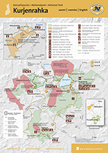
Karpalopolku trail, 1.7 km demanding accessible circle trail
The marshland scenery of Southwest Finland with all its scents and sounds is captivating, even during a shorter journey! The famous Kuhankuono boundary mark is also located along the trail.

A demanding accessible trail.
Fully accessible only during the snow-free season.
The estimated travel time by wheelchair is one hour.
Starting point
Address: Kurjenpesän pysäköintialue, Kuhankuonontie, Pöytyä (pdf 6 Mt, julkaisut.metsa.fi)
Coordinates: Euref-Fin (~ WGS84) 60.740009°, 22.415941°, ETRS-35FIN N: 6742554 E: 250183
Driving instructions
When arriving from Turku, drive towards Tampere (road number 9). Approximately 17 kilometres from Turku, turn onto the road to Säkylä (road no. 204). Drive along the road for approximately 18 kilometres, and then turn left on the Kuhankuonontie road right after the national park sign.
There are two parking areas for cars. At the start of Kuhankuonontie, there is the Kurjenportti parking area which is maintained by the municipality of Pöytyä. From there, you can take the path through the forest or walk along the Kuhankuonontie road to Kurjenpesä (Kuhankuonontie 67). The distance is approximately 700 metres. There is also a smaller parking area at Kurjenpesä, which is recommended especially for park guests using mobility aids.
Hiking structures
- There are two marked accessible spaces in the parking area with a gravel surface.
- The Karpalopolku trail starts from the Kurjenpesä parking area. At the beginning of the trail, there is an information board with a raised-relief map and an audio description of the trail for persons with visual impairments.
- Along the Karpalopolku trail, there is a lookout platform and some signs and recordings in Finnish for persons with visual impairments.
- A 100-metre path leads from the Kurjenpesä parking area to Kurjenpesä with its accessible structures, which include a nature information hut, a cooking shelter, a lookout platform, a recycling point and a dry toilet.
- The firewood shelter at Kurjenpesä is not fully accessible.
- The Kurkela meeting venue is available for daytime rent.
- There is a camping area next to Kurjenpesä.
Trail description
- For the most parts, the trail is 1.2 metres wide. The narrowest points, 1.1 metres, are the duckboard sections.
- The trail is marked with yellow wooden squares on trees on the right side of the trail, at a height of approximately 1.8 metres.
- There are wooden signs at the height of approximately 1 metre.
- The trail is surfaced with rock dust. There are approximately three sections of wide duckboards, for a total of 330 metres.
- There is no excessive lateral slope on the trail that would impede the movement of people with mobility aids. Slight unevenness is possible.
- The trail has been classified as demanding due to a few ascents and descents along the way, and an assistant is recommended for wheelchair users. Large front wheels designed for off-road use or a single front wheel will facilitate travelling with wheelchairs. The users of electric wheelchairs or electric mopeds may not necessarily experience any problems on the trail.
- Trail direction: clockwise.
Terrain signs
- The terrain signs are placed at the height of approximately 1.4 metres. The height of the terrain signs is indicated as the distance of each sign’s middle part from the ground.
- Along the trail, there is a three-dimensional metal model of a Crane (Grus grus) and of the Common Sundew (Drosera rotundifolia), as well as nature information boards. Some of the nature information boards include audio recordings or parts you can touch.
More:
- video (youtube.com)
- Descriptions of the trail (mapeirons.eu)


Vajosuo Mire trail, 3 km circle trail
The trail takes you through dense old-growth forests to the edge of the magnificent mire, inhabited by cranes. The mire landscape offers a perfect place to rest, enjoy a snack or even spend the night.
- Open all year round, walking time two hours.
- Suitable for beginners.
Starting point
Address: Vajosuo parking area, Vajosuontie, Rusko
Coordinates: Euref-Fin (~ WGS84) lat: 60° 40.9912' lon: 22° 22.7233' ETRS-TM35FIN N: 6736378 E: 2477111
Hiking structures
At the edge of Vajosuo Mire, there is lean-to shelter, a campfire site, a cooking shelter for groups and a dry toilet. Bring your own toilet paper. There is an observation tower 200 metres from the trail. Vajosuo Rental Hut is available from 1 May to 1 October.
Sights
In addition to birdwatching, the Vajosuo observation tower is a perfect place to admire the mire landscape spreading out around you.

Trail description
- Trail markings: orange.
- Recommended hiking direction: counterclockwise.
- The distance from the Vajosuo parking area to the edge of Vajosuo Mire is 1.5 kilometres. There visitors have access to a lean-to shelter, a separate campfire site and the reservable Vajosuo Rental Hut. The cooking shelter is suitable for groups. A short trail goes to the observation tower from the edge of the mire. The trail goes mostly in the forest. The trail joins up with Kuhankuono Hiking Trail Network, which allows visitors to take the 30-kilometre hike of Vajosuo Mire.


Lake Savojärvi trail, 6 km circle trail
The naturally pristine and tranquil marshland scenery with all its scents captivates the hiker at Lake Savojärvi. In the wintertime, the stillness of the open scenery is beyond compare. The famous Kuhankuono boundary mark is accessible both by wheelchair and with a baby pram during the snow-free season.
The trail is open all year round, also during the period of restricted access to Lammenrahka (15 January – 15 July). Walking time: 2.5 hours.
The beginner-friendly first section of the trail (300 m) from the Kurjenpesä parking area to the Kuhankuono boundary mark is part of the Karpalopolku trail and accessible by wheelchair or with a baby pram.
Starting points
Address: Kurjenpesä parking area, Kuhankuonontie, Pöytyä, and Rantapiha parking area, Savojärventie, Nousiainen (pdf 6 MB, julkaisut.metsa.fi)
Coordinates of Kurjenpesä: Euref-Fin (~ WGS84) lat: 60° 44.4023' lon: 22° 24.9530' ETRS-TM35FIN N: 6742558 E: 250180
Coordinates of Rantapiha: Euref-Fin (~ WGS84) lat: 60° 44.6202' lon: 22° 23.3962' ETRS-TM35FIN N: 6743061 E: 248796
Hiking structures
There is a nature information hut, water tap, cooking shelter and dry toilet at Kurjenpesä. All amenities are accessible by wheelchair. The water tap is on the wall of Kurjenpesä Nature Information Hut. Rantapiha has a cooking shelter, dry toilet and a summer kiosk, operated by the Kuhankuono trail association (kuhankuono.fi). Bring your own toilet paper.

Sights
Kuhankuono boundary mark, the Finnish Civil War memorial in Vähä-Välisaari.
Trail description
- Trail markings: orange.
- Recommended hiking direction: clockwise
- The Lake Savojärvi trail, six kilometres in length, runs from Kurjenpesä Nature Information Hut around Lake Savojärvi. The trail runs on duckboards across the mire sections, and there are rest areas along the trail. The trail is easy to walk. There are several mire sections along the trail. The trail joins up with Kuhankuono Hiking Trail Network, which allows visitors to take the 30-kilometre hike of Vajosuo.
Other hiking trails 0–10 km

Pukkipalo trail, 6 km or 9 km circle trail
Paradise for anyone who loves forests. The primeval forests of Pukkipalo bear witness to times long gone, and information boards along the trail introduce you to the species of the old forest.
Open all year round, walking time 2.5–3.5 hours.
Starting points
Address: Pukkipalo parking area, Paltantie, Nousiainen, and Rantapiha parking area, Savojärventie, Nousiainen (pdf 6 MB, julkaisut.metsa.fi)
Coordinates of Pukkipalo: Euref-Fin (~ WGS84) lat: 60° 44.7158' lon: 22° 24.0376' ETRS-TM35FIN N: 6743325 E: 247576
Coordinates of Rantapiha: Euref-Fin (~ WGS84) lat: 60° 44.6202' lon: 22° 23.3962' ETRS-TM35FIN N: 6743061 E: 248796
Hiking structures
There is a campfire site and a dry toilet at Takaniitunvuori Hill in the southern end of the Pukkipalo trail and a lean-to shelter and a dry toilet at Lake Lakjärvi in the northern end of the trail. Rantapiha has a cooking shelter, dry toilet and a summer kiosk, operated by the Kuhankuono trail association (kuhankuono.fi). Bring your own toilet paper.

Sights
Pukkipalo old-growth forest; spectacular views over the mire from Takaniitunvuori Hill.
Trail description
- Recommended hiking direction: counterclockwise.
- Trail markings: orange (since 2018).
- The Pukkipalo trail is slightly under six kilometres long if you set out from the Pukkipalo parking area. Another possible starting point is Rantapiha, in which case the trail is just under nine kilometres long. A 2.8-kilometre section of the trail runs within the national park boundaries, whereas the rest is part of Kuhankuono Hiking Trail Network.
- In the Pukkipalo primeval forest, along a section of approximately one kilometre on the Pukkipalo-Takaniitunvuori trail, there are nature information boards introducing visitors to the species of the old forest. The nature trail is not a circle trail, but a part of the Pukkipalo trail.
- North of the Pukkipalo trail, only 0.6 kilometres away, lies the lean-to shelter of Lakjärvi. From Lake Lakjärvi, you can continue your hike outside the national park along the Kuhankuono Hiking Trail Network (kuhankuono.fi). The distance from the Pukkipalo parking area to the Takaniitunvuori lookout point and campfire site is 3.6 kilometres.

Other hiking trails over 10 km
The hike of Vajosuo Mire, 30 km circle trail

Two days of fun, even for an experienced hiker. The trail runs partly in Kurjenrahka National Park and also outside the park.
Open all year round, walking time two days.
The trail is mostly quite even and relatively easy to walk.
Starting points
Address: Kurjenpesä parking area, Kuhankuonontie 67, Pöytyä; Rantapiha parking area, Savojärventie, Nousiainen; Vajosuo parking area, Vajosuontie, Rusko and Töykkälä parking area, Vällintie, Rusko
Coordinates of Kurjenpesä: Euref-Fin (~ WGS84) lat: 60° 44.4023' lon: 22° 24.9530' ETRS-TM35FIN N: 6742558 E: 250180
Coordinates of Rantapiha: Euref-Fin (~ WGS84) lat: 60° 44.6202' lon: 22° 23.3962' ETRS-TM35FIN N: 6743061 E: 248796
Coordinates of Vajosuo Mire: Euref-Fin (~ WGS84) lat: 60° 40.9912' lon: 22° 22.7233' ETRS-TM35FIN N: 6736378 E: 2477111
Coordinates of Töykkälä: Euref-Fin (~ WGS84) lat: 60° 42.5000' lon: 22° 23.6321' ETRS-TM35FIN N: 6739116 E: 2487331
Hiking structures
There is a nature information hut, water tap, cooking shelter and dry toilet at Kurjenpesä. All amenities are accessible by wheelchair. The water tap is on the wall of Kurjenpesä Nature I

Hiking structures
- Information Hut.
- Rantapiha has a cooking shelter and a dry toilet, maintained by the Kuhankuono trail association.
- In the northern end of the Pukkipalo trail, at Lake Lakjärvi, there is a lean-to shelter and a dry toilet, and in the southern end, at Takaniitunvuori Hill, there is a campfire site.
- At the edge of Vajosuo Mire, there is lean-to shelter, a campfire site, a cooking shelter for groups and a dry toilet. There is an observation tower 200 metres from the trail.
- Vajosuo Rental Hut is available from 1 May to 1 October. There is a lean-to shelter and a dry toilet in Töykkälä. The Koivusaari observation tower is located just over four kilometres away from Töykkälä.
- Bring your own toilet paper.
Sights
- Kuhankuono boundary mark, the Finnish Civil War memorial in Vähä-Välisaari.
- Pukkipalo old-growth forest; spectacular views over the mire from Takaniitunvuori Hill.
- In addition to birdwatching, the Vajosuo and Koivusaari observation towers are perfect places to admire the mire landscape spreading out all around.
Trail description
Trail markings: orange.
Recommended hiking direction: counterclockwise.

The best starting points for the trail are Rantapiha or Kurjenpesä in the north and the Vajosuo parking area in the south. When planning your hike, always make sure that there is a shelter available when the day turns into evening.
During the hike, you get to see the great mires of Kurjenrahka National Park, namely Vajosuo and Kurjenrahka. These wide open marshlands in their natural state offer an impressive scenery throughout the year. The trail also passes the Pukkipalo old-growth forests and Lake Savojärvi. There are accessible sections along the trail around Kurjenpesä. Outside the national park, the scenery along the trail varies from commercial forests to well-maintained rural landscapes. The trails outside the national park are part of Kuhankuono Hiking Trail Network (www.kuhankuono.fi).

Kuhankuono Hiking Trail Network, 150 km
Kuhankuono Hiking Trail Network (kuhankuono.fi) is a network of trails implemented jointly by the Regional Council of Southwest Finland and local municipalities and landowners. The network comprises a total of 150 kilometres of paths, duckboards and forest roads. The trails are mostly maintained by the local municipalities, but Metsähallitus is in charge of the services and structures within Kurjenrahka National Park and Vaskijärvi Strict Nature Reserve.
Lake Vaskijärvi trail, 19 km circle trail
Services
There are no services available in the Vaskijärvi Strict Nature Reserve area.
Trail description
The trail passes through Vaskijärvi Strict Nature Reserve in two places: for a section of around three kilometres in the northern part of the area, and for another stretch of about 2.3 kilometres in the south. In the southern part of the nature reserve, it is also possible to hike on a 3.2-kilometre circle trail. The trail starts from outside the park from Vesirauma Hill, passes by the shore of Lake Kajavajärvi, and returns to Vesirauma Hill. There are duckboards across the wettest areas of the nature reserve trails, but when the water level is high, visitors will need rubber boots to keep their feet dry. In Vaskijärvi Strict Nature Reserve, it is forbidden to walk outside the marked trail.

Please note
In Vaskijärvi Strict Nature Reserve, it is forbidden to walk outside the marked trail.

Ski tracks
Kurjenrahka ski trail, 9 km circle trail
The stillness and vastness of marshlands in the wintertime – that is all you need.
The Kuhankuono trail association (kuhankuono.fi) maintains the ski track when snow conditions permit.
A relatively easy traditional cross-country style ski track for beginners, families and groups.
Starting points
Address: Kurjenpesä parking area, Kuhankuonontie 67, Pöytyä, and Rantapiha parking area, Savojärventie, Nousiainen
Coordinates of Kurjenpesä: Euref-Fin (~ WGS84) lat: 60° 44.4023' lon: 22° 24.9530' ETRS-TM35FIN N: 6742558 E: 250180
Coordinates of Rantapiha: Euref-Fin (~ WGS84) lat: 60° 44.6202' lon: 22° 23.3962' ETRS-TM35FIN N: 6743061 E: 248796
Hiking structures
Kurjenpesä has an accessible nature information hut, a cooking shelter and a dry toilet. There is a water tap on the wall of Kurjenpesä Nature Information Hut. Rantapiha has a cooking shelter and a dry toilet, maintained by the Kuhankuono trail association. Bring your own toilet paper.
Sights
Kuhankuono boundary mark, the Finnish Civil War memorial in Vähä-Välisaari.
Trail description
Recommended hiking direction: counterclockwise.
The ski track makes a 9-kilometre loop at Kurjenrahka Mire, with hardly any changes in elevation.