


Hiidenkierros Trail, 3 - 5 km / Circle Trail
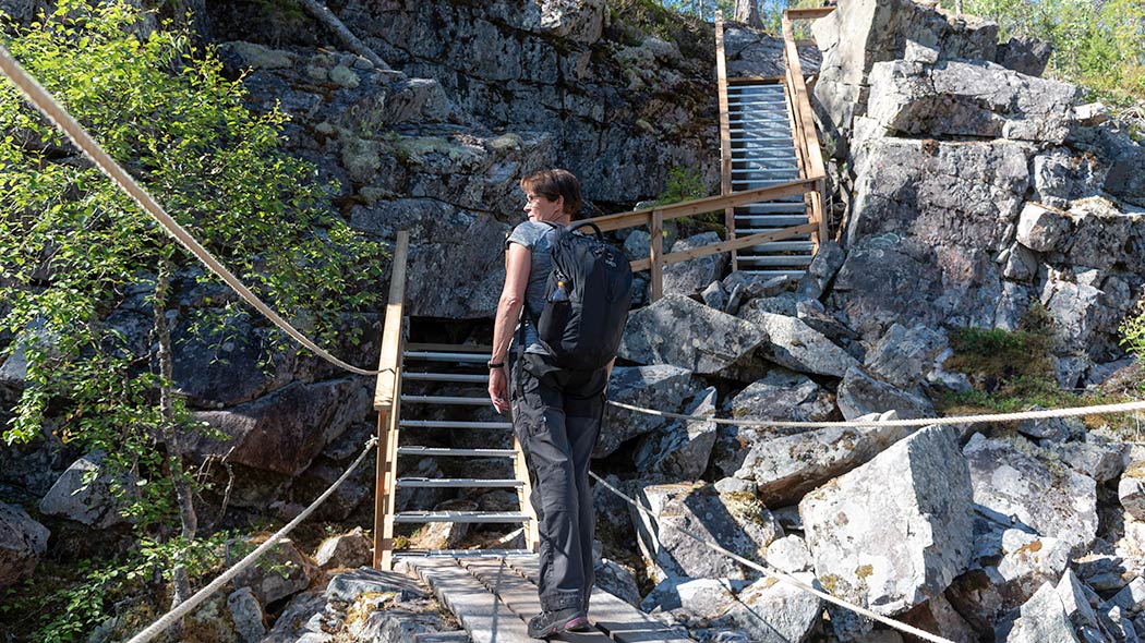
The Hiidenkierros Trail leads you to the majestic Hiidenportti Gorge. The trail descends to the bottom of the gorge and ascends via steps to the other side of the cliffs.
Available when the ground is unfrozen. In winter with snow shoes. The road Hiidenportintie to the Palolampi parking place is ploughed in winter.
Travel time 2-4 h.
Category:  intermediate
  demanding
Starting Point
Palolampi parking area.
Hiking Structures
Information point at Palolampi. There is campfire site, a cooking shelter and a well at the information point. In the turning point of the route there is a lean-to shelter at lake Porttilampi. In the field of Kovasinvaara there is an information board telling about life at the remote wilderness farm.
Sights
Hiidenportti Gorge and Kovasinvaara. Marks of the human activities can also be seen along the trail, such as a base of a tar-burning pit. You can explore the cultural history of the area also with the help of the "Hiidenportti through the ages" -brochure.
Trail Description
Marked with purple paint.
The marked trail leads from the Palolampi information point to the Hiidenportti Gorge. From there on the trail continues towards the Porttilampi lean-to shelter. This section runs along the edge of the gorge cliffs for about one kilometre. The trail is demanding, but it also offers the most rewarding views. The Porttilampi lean-to shelter offers a perfect place for a break and a snack.
From Porttilampi the Hiidenkierros Trail comes back the same trail for about one kilometer and continues towards the Kovasinvaara hill. There are no buildings left on the hill, but the meadows, birch forests and heaps of stones give you a glimpse of times gone by. The last section of the trail runs back to Palolampi. This section is somewhat demanding as in some places the descent to Palolampi is rather steep.
Please Note
The trail is rather demanding especially near the Hiidenportti gorge because of the rocky terrain. There are also some rather steep altitude differences along the Hiidenkierros Trail.
There is no designated direction for the Hiidenkierros Trail, but especially hikers with dogs are recommended to walk the trail clockwise, because it is easier for the dogs to climb the steep steps at the gorge upwards than downwards.


Kitulankierros Trail, 10.5 km / Circle Trail
Available when the ground is unfrozen. In winter with snow shoes or skis (no maintained winter trails). Travel time 5-7 h.
Category: intermediate demanding
Starting Point
Palolampi parking area.
Hiking Structures
Palolampi information point, lean-to shelters by Lake Porttilampi and Lake Kitulanlampi.
Sights
Hiidenportti Gorge, Kovasinvaara and other sights of cultural-historical interest in the area.
Trail Description
Marked with yellow paint
The Kitulankierros Trail starts from Palolampi and continues through Hiidenportti to Porttilampi along the same route as the Hiidenkierros Trail. It then continues through mires and forests towards lake Kitulanlampi. At Kitulanlampi you slip from the forest atmosphere to the scenery of cliffs and lakes. The Kitulanlampi lean-to shelter is situated at a very beautiful point at the tip of a long narrow cape. From Kitulanlampi the trail leads north-west through old-growth forest, passing the trail leading south to Allaslahti.
For a few hundred meters the trail goes along the border of the national park, and in here the difference between a protected area and a managed forest is very clearly seen. After this the trail continues towards the gorge, but a bit before coming to the cliffs, the trail turns towards Kovasinvaara hill and its surprising meadows.
From Kovasinvaara the trail leads back to the Palolampi information point.
Please Note
The Kitulankierros Trail is rather demanding especially near the Hiidenportti gorge because of the rocky terrain. There are also some rather steep altitude differences along the Kitulankierros Trail.
There is no designated direction for the trail, but especially hikers with dogs are recommended to walk the trail clockwise, because it is easier for the dogs to climb the steep steps at the gorge upwards than downwards.


Other Trails
Other trails in Hiidenportti National Park are marked with orange paintings.
The main hiking trail leading through the National Park, 11,5 km


Available when the ground is unfrozen. Travel time 5-7 h.
Category: intermediate demanding
Starting Point
Palolampi information point and Käärmesärkkä parking area.
Hiking Structures
There are lean-to shelters and campfire sites along the trail. Services depend on chosen route.
Sights
Depending on your route Hiidenportti Gorge, Kovasinvaara or both.
Trail Description
Marked with orange paint.
The trail follows the River Porttijoki, which begins from the Hiidenportti Gorge, to the south-eastern corner of the park to Käärmesärkkä parking area. From Käärmesärkkä there is a connection to Peurajärvi recreational area. The length of the trail from Hiidenportti Gorge to Käärmesärkkä is about 10 km.


The hiking trail beginning from the Urpovaara parking area, length depends on the route choice
Available when the ground is unfrozen. Travel time 3-7 h.
Category:  easy - demanding
Starting Point
Urpovaara parking area. The forest road Perävaarantie is not ploughed in winter.
Hiking Structures
Services depend on chosen route.
Sights
Huge spruce forests of the Urpovaara hill. Depending on the route Hiidenportti Gorge, Kovasinvaara or both.
Trail markings
Marked with orange paintings
Trail Description
The trail leads through old spruce forests on the slopes of Urpovaara Hill. The distance from Urpovaara to Hiidenportti Gorge is 4,3 km.


The trail leading from Hiidenportti Gorge to Allaslahti Bay, 6.7 km
Available when the ground is unfrozen. In winter on skis or snow shoes. Travel time 3-7 h.
Category: easy - demanding
Starting Point: The signed trail begins from the Kitulankierros Trail about 1,6 km from the Hiidenportti Gorge.
Hiking Structures
Allaslahti lean-to shelter. Other services depend on which route visitors choose.
Sights
Hiidenportti Gorge
Trail markings
Marked with orange paint
Trail Description
Trail is in the south part of the National Park leads through terrain typical of the National Park; mires and forest heaths. At Allaslahti Bay the trail connects with trail Talonpojan Taival, which leads to Valtimo.


Hiking Trails
There are almost 30 km of marked and duckboard covered trails in Hiidenportti National Park.

Starting Points for Trails
Palolampi
The area's most popular starting point is Palolampi information point, which has an adjacent campfire site, a cooking shelter and a well, and a rental cabin for day use.
Urpovaara
There is a forest road named "Perävaarantie" leading to Urpovaara parking place from the road Kuhmo-Valtimo (no 5284). The road is not ploughed in winter.
Käärmesärkkä
The Käärmesärkkä starting point is situated along the road Kuhmo-Valtimo (no 5284). The parking place is not ploughed in winter.

Circle Trails
Hiidenkierros Trail, 3 - 5 km / Circle Trail
Available when the ground is unfrozen. In winter with snow shoes. Travel time 2-4 h.
Category: intermediate
The Hiidenkierros Trail leads you to the majestic Hiidenportti Gorge. The trail descends to the bottom of the gorge and ascends via steps to the other side of the cliffs.

Starting Point
Palolampi parking area.
Hiking Structures
Information point at Palolampi. There is campfire site, a cooking shelter and a well at the information point. In halfway of the route there is a lean-to shelter at Lake Porttilampi. In the grounds of Kovasinvaara there is an information board about the life in the remote wilderness farm.
Sights
Hiidenportti Gorge and Kovasinvaara. Marks of the human activities can also be seen along the trail, such as a base of a tar-burning pit. You can explore the cultural history of the area also with the help of the "Hiidenportti through the ages" -brochure.

Trail Description
Marked with purple paint.
From Hiidenportti the trail continues towards the Porttilampi lean-to shelter. This section runs along the edge of the cliff for almost a kilometre. It is the most demanding section of both the trails, but also offers the most rewarding views.
From Porttilampi lean-to shelter you go back 1 km to Hiidenportti and turn towards the Kovasinvaara hill. There are no buildings left on the hill, but the meadow, birch forests and heaps of stones give you a glimpse of times gone by. The last section of the trail runs back to Palolampi. This section is somewhat demanding as the descent to Palolampi is rather steep.
Please Note
There are no significant altitude differences along the Hiidenkierros Trail, but the forest path is lumpy and also stony in places.
Please note that the stairs down to the valley are in some parts in bad condition.
Kitulankierros Trail, 10.5 km / Circle Trail
Available when the ground is unfrozen. Travel time 5-7 h.
Category: intermediate demanding

Starting Point
Palolampi parking area.
Hiking Structures
Palolampi information point, lean-to shelters by Lake Porttilampi and Lake Kitulanlampi.
Sights
Hiidenportti Gorge, Kovasinvaara and other sights of cultural-historical interest in the area.
Trail Description
Marked with yellow paint
The Kitulankierros Trail starts from Palolampi and continues through Hiidenportti to Porttilampi. It then continues through mires towards the impressive spruce forests of the Urpovaara hill. At Kitulanlampi you slip from the forest atmosphere to the scenery of cliffs and lakes. There is also a lean-to shelter at the tip of a long cape. From there the trail returns to the old-growth forest. The flora and fauna of the old-growth forest is still alive and well here.
When the trail meets the path going towards Allaslahti, you are treading on a path used by the ancient inhabitants of Kovasinvaara. The trail continues to the Hiidenportti Gorge and returns through Kovasinvaara to Palolampi.
Please Note
The Kitulankierros Trail is demanding in places.

Other Trails
Other trails in Hiidenportti National Park are marked with orange paintings.
The main hiking trail leading through the National Park, 11,5 km
Available when the ground is unfrozen. Travel time 5-7 h.
Category: intermediate demanding

Starting Point
Palolampi information point and Käärmesärkkä parking area.
Hiking Structures
There are lean-to shelters and campfire sites along the trail. Services depend on chosen route.
Sights
Depending on your route Hiidenportti Gorge, Kovasinvaara or both.
Trail Description
Marked with orange paint.
The trail follows the River Porttijoki bank to the southern boundary of the park and then on to Käärmesärkkä and to Peurajärvi recreational fishing area southeast of the National Park. The length of the trail from Hiidenportti Gorge to Käärmesärkkä is about 10 km.
The hiking trail beginning from the Urpovaara parking area, length depends on the route choice
Available when the ground is unfrozen. Travel time 3-7 h.
Category: easy - demanding

Starting Point
Urpovaara parking area. The forest road Perävaarantie is not ploughed in winter.
Hiking Structures
Services depend on which route visitors choose.
Sights
Spruce forests. Depending on your route Hiidenportti Gorge, Kovasinvaara or both.
Trail markings
Marked with orange paint
Trail Description
Trail leads through old spruce forests on the slopes of Urpovaara Hill. The distance from Urpovaara to Hiidenportti Gorge is 4,3 km.
The trail leading from Hiidenportti Gorge to Allaslahti Bay, 6,7 km
Available when the ground is unfrozen. In winter on skis or snow shoes. Travel time 3-7 h.
Category: easy - demanding
Starting Point: The signed trail begins from the Kitulankierros Trail about 1,6 km from the Hiidenportti Gorge.
Hiking Structures
Allaslahti lean-to shelter. Other services depend on which route visitors choose.
Sights
Hiidenportti Gorge
Trail markings
Marked with orange paint
Trail Description
Trail is in the south part of the National Park leads through terrain typical of the National Park; mires and dry forests. At Allaslahti Bay the trail connects with Talonpojan Taival, which is part of the Karelian Circuit (vaellus.info, in Finnish).
Connecting Trails
- From the crossroads to Urpovaara there is a marked trail leading to the Teeri-Lososuo Mire Reserve.
- In its southeast Hiidenportti National Park shares its border with the Metsähallitus Peurajärvi recreational fishing area (eraluvat.fi). There is a trail leading from the National Park to Peurajärvi. From Peurajärvi the trail continues as the Karelian Circuit (vaellus.info, in Finnish) for hundreds of kilometres.
- Talonpojan Taival Trail begins from Allaslahti Bay. It is 45 km and part of the Karelian Circuit (vaellus.info, in Finnish).
Hiidenportti Brochure


