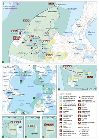
Hiking Trails
There are about 17 km of marked trails around Manamansalo camping ground. The trails go into the dry pine forests of the island, so the terrain is not difficult. Along the trails, you can see many special features of Manamansalo Island, such as lichen heaths, the steep shores of Lake Oulujärvi, the old-growth forest of Rapsunkangas, the old tar-burning tradition, and many forest lakes with clear water, which are popular places for recreational fishing.
Starting Points for the Trails
Circle Trails
- Trails around the lakes of Manamansalo. Alternative routes.
- Services: Rental boats, a lean-to shelter, a campfire site and a campfire hut at Lake Särkinen, a campfire site at Lake Syväjärvi, a hut with a fireplace at Lake Iso-Peura, a campfire site at Lake Kota-Peura.
- Sights: Recreational fishing areas, the forest lakes with clear water, steep-sided "suppa" holes in the ground (marks of large blocks of ice, which got buried in the sand during the Ice Age, and then melted), lichen heaths, marks of the old tar-burning traditions.
Other Trails
- Makkaraniemi Trail. Starts at the camping ground of Manamansalo, alternative routes.
- Services: A campfire place in Pantiokangas by Lake Oulujärvi, a hut with a fireplace at Makkaraniemi
- Sights: The large open waters and the steep shores of Lake Oulujärvi, the old-growth forest of Rapsunkangas, a long sandy cape at Makkaraniemi, lichen heaths, the shores of Lake Kaaresjärvi
- Kuostonsaari Trail, 4 km, a hiking trail which runs in east-west direction.
- Services: Lean-to shelters at the both ends of the trail, landing places for boats
- Sights: The island of Kuosto, the large open waters of Lake Oulujärvi
Boating and Canoeing Routes
The area is part of the "Oulujoki River Tar Route" from the eastern border of Finland to the city of Oulu.
Snow Mobile Routes and Tracks
There are no snowmobile routes in the hiking area, therefore using snow mobiles is only allowed on the ice of the lake.