By Car to Lake Oulujärvi
Manamansalo camping ground. Teeriniementie 156, 88340 Manamansalo. CLOSED UNTIL SPRING 2024.
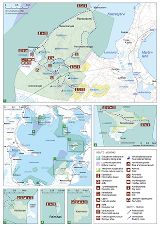
By car, the distance to the Oulujärvi Hiking Area from Kajaani is 80 km and from Vaala 50 km. Manamansalo Island can be accessed by turning from Highway 22 (Oulu-Kajaani) onto road 8823 (Petäjälahdentie) or using the Alassalmi ferry from the southern shore of Lake Oulujärvi. The ferry operates roughly every 30 minutes, providing a memorable summer experience, especially for children.
By Boat to Lake Oulujärvi
Using your own boat, you can land on the islands in the hiking area. Please note that the shores can be shallow and rocky. Discover the services available for boaters.
Teeriniemi boat harbour, Manamansalo Island. Teeriniementie 156, Vaala. EUREF-FIN coordinates (~ WGS 84) lat: 64° 23.5383' lon: 27° 01.3354' ETRS-TM35FIN: N: 7140731 E: 501073
Kuoston Kulma boat jetty, Kuostonsaari Island. EUREF-FIN coordinates (~ WGS 84) lat: 64° 27.6384' lon: 27° 05.8420' ETRS-TM35FIN: N: 7148351 E: 5004682
Kaarresalo Island boat jetty. EUREF-FIN coordinates (~ WGS 84) lat: 64° 29.6573' lon: 27° 04.1121' ETRS-TM35FIN: N: 7152098 E: 503294
Honkinen Island boat jetty. EUREF-FIN coordinates (~ WGS 84) lat: 64° 31.1440' lon: 26° 54.9852' ETRS-TM35FIN: N: 7154861 E: 495987